Датотека:Dinaric Alps subdivisions-fr.svg

Veličina PNG pregleda za ovu SVG datoteku je 741 × 600 piksela. 6 drugih rezolucija: 297 × 240 piksela | 593 × 480 piksela | 949 × 768 piksela | 1.265 × 1.024 piksela | 2.530 × 2.048 piksela | 1.857 × 1.503 piksela.
Originalna datoteka (SVG datoteka, nominalno 1.857 × 1.503 piksela, veličina: 3,5 MB)
| Ovo je datoteka sa Vikimedijine ostave. Informacije sa njene stranice sa opisom prikazane su ispod. Vikimedijina ostava je skladište slobodno licenciralnih multimedijalnih datoteka. I Vi možete da pomognete. |
Opis izmene
| Opis |
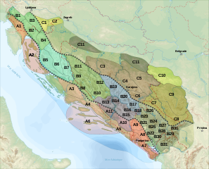
English: Geo-morphological and structural subdivisions map by of Dinaric Alps
Français : Carte des subdivisions géo-morphologiques et structurelles de la chaîne des Alpes Dinariques :
|
||
| Datum | |||
| Izvor |
travail personnel (own work). Sources :
|
||
| Autor | Sémhur | ||
| Ostale verzije | |||
| Autorstvo (required by the license) | © Sémhur / Wikimedia Commons / | ||
| SVG | W3C-validity not checked.
|
||
| Graphic Lab |

| Положај камере | | Ова и друге слике снимљене у близини на: OpenStreetMap |
|---|
Licenciranje
Ja, nosilac autorskih prava nad ovim delom, objavljujem isto pod sledećim licencama:
| Copyleft: This work of art is free; you can redistribute it and/or modify it according to terms of the Free Art License. You will find a specimen of this license on the Copyleft Attitude site as well as on other sites. |
This file is licensed under the Creative Commons Attribution-Share Alike Attribution-Share Alike 4.0 International, 3.0 Unported, 2.5 Generic, 2.0 Generic and 1.0 Generic license.
- Dozvoljeno je:
- da delite – da umnožavate, raspodeljujete i prenosite delo
- da prerađujete – da preradite delo
- Pod sledećim uslovima:
- autorstvo – Morate da date odgovarajuće zasluge, obezbedite vezu ka licenci i naznačite da li su izmene napravljene. Možete to uraditi na bilo koji razuman manir, ali ne na način koji predlaže da licencator odobrava vas ili vaše korišćenje.
- deliti pod istim uslovima – Ako izmenite, preobrazite ili dogradite ovaj materijal, morate podeliti svoje doprinose pod istom ili kompatibilnom licencom kao original.
Izaberite licencu po želji.
Istorija datoteke
Kliknite na datum/vreme da biste videli tadašnju verziju datoteke.
| Datum/vreme | Minijatura | Dimenzije | Korisnik | Komentar | |
|---|---|---|---|---|---|
| trenutna | 23:37, 29. novembar 2008. | | 1.857 × 1.503 (3,5 MB) | Sémhur | Renumérotation + capitales |
| 12:28, 29. novembar 2008. |  | 1.857 × 1.503 (3,48 MB) | Sémhur | == Description == {{Information |Description= {{en|1=Geo-morphological and structural subdivisions map by of Dinaric Alps, in French.}} {{fr|1=Carte des subdivisions géo-morphologiques et structurelles de la chaîne des [[:fr:Alpes D |
Upotreba datoteke
Sledeća stranica koristi ovu datoteku:
Globalna upotreba datoteke
Drugi vikiji koji koriste ovu datoteku:
- Upotreba na bg.wikipedia.org
- Upotreba na bs.wikipedia.org
- Upotreba na da.wikipedia.org
- Upotreba na de.wikipedia.org
- Upotreba na en.wikipedia.org
- Upotreba na eu.wikipedia.org
- Upotreba na fr.wikipedia.org
- Alpes dinariques
- Durmitor
- Dinara
- Bjelasica
- Prokletije
- Velebit (massif)
- Zlatibor (montagne)
- Plateau du Karst
- Gorjanci/Žumberak
- Zlatar (montagne)
- Lička Plješivica
- Mala Kapela
- Prenj
- Velika Kapela
- Zelengora
- Monts Morača
- Monts Kučka krajina
- Komovi
- Sinjajevina
- Wikipédia:Atelier graphique/Cartes/Archives/février 2009
- Upotreba na it.wikipedia.org
- Upotreba na lt.wikipedia.org
- Upotreba na no.wikipedia.org
- Upotreba na pl.wikipedia.org
- Upotreba na sk.wikipedia.org
- Upotreba na sl.wikipedia.org
Još globalnog korišćenja ove datoteke.