Датотека:Empire akkad.svg

Originalna datoteka (SVG datoteka, nominalno 1.475 × 1.149 piksela, veličina: 2,34 MB)
| Ovo je datoteka sa Vikimedijine ostave. Informacije sa njene stranice sa opisom prikazane su ispod. Vikimedijina ostava je skladište slobodno licenciralnih multimedijalnih datoteka. I Vi možete da pomognete. |
Opis izmene

|
This SVG file contains embedded text that can be translated into your language, using any capable SVG editor, text editor or the SVG Translate tool. For more information see: About translating SVG files. |
| Opis |
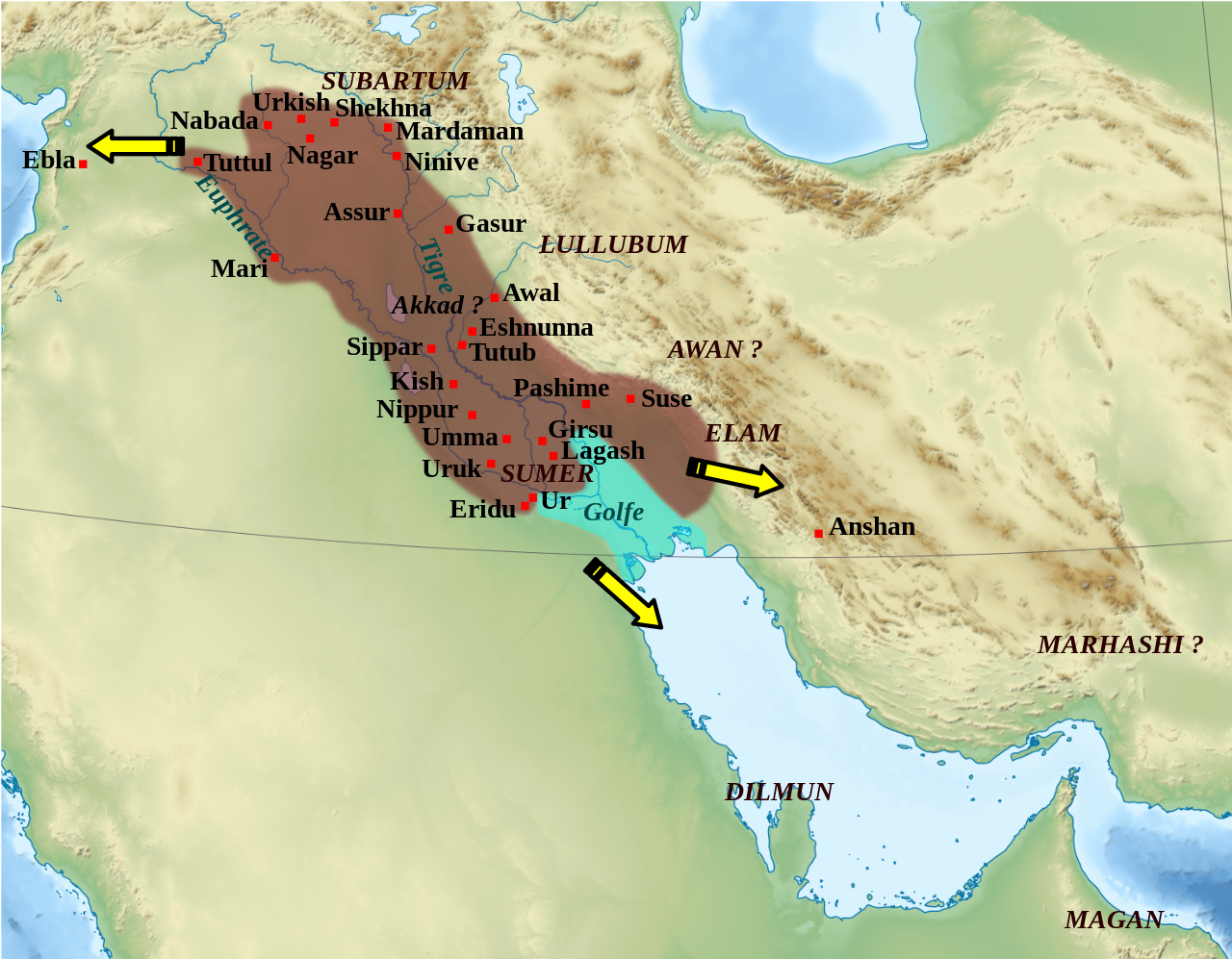
English: Mapa que mostra l'extensió aproximada de l'imperi Accadi durant el regnat de Narâm-Sîn (2254-2218 a.C. en la cronologia breu). Français : Carte de l'extension approximative de l'empire d'Akkad sous le règne de Narâm-Sîn (2254-2218 av. J.-C. selon la chronologie moyenne), et des directions des campagnes militaires extérieures. Sources : B. Lafont et M. Sauvage dans M. Sauvage (dir.), Atlas historique du Proche-Orient ancien, Paris, Les Belles Lettres, 2020, p. 70 ; P. Michalowski, « The Kingdom of Akkad in Contact with the World », dans The Oxford History of the Ancient Near East, Volume 1: From the Beginnings to Old Kingdom Egypt and the Dynasty of Akkad, New York, Oxford University Press, 2020, p. 688 fig. 10.1. |
| Datum | (UTC) |
| Izvor | |
| Autor |
|
| Ostale verzije |
File:Empire akkad.svg has 2 translations.
Other related versions: []
|


| Положај камере | | Ова и друге слике снимљене у близини на: OpenStreetMap |
|---|
|
|
This SVG file contains embedded text that can be translated into your language, using any capable SVG editor, text editor or the SVG Translate tool. For more information see: About translating SVG files. |
This file is translated using SVG <switch> elements. All translations are stored in the same file! Learn more.
For most Wikipedia projects, you can embed the file normally (without a To translate the text into your language, you can use the SVG Translate tool. Alternatively, you can download the file to your computer, add your translations using whatever software you're familiar with, and re-upload it with the same name. You will find help in Graphics Lab if you're not sure how to do this. |
| Ово је ретуширана слика, што значи да је дигитално измењена у односу на своју изворну верзију. Измене: Ajout des villes, du contour approximatif de l'empire.. Изворна верзија се може видети овде: Middle East topographic map-blank.svg. Измене је направио: Zunkir.
|
Licenciranje
- Dozvoljeno je:
- da delite – da umnožavate, raspodeljujete i prenosite delo
- da prerađujete – da preradite delo
- Pod sledećim uslovima:
- autorstvo – Morate da date odgovarajuće zasluge, obezbedite vezu ka licenci i naznačite da li su izmene napravljene. Možete to uraditi na bilo koji razuman manir, ali ne na način koji predlaže da licencator odobrava vas ili vaše korišćenje.
- deliti pod istim uslovima – Ako izmenite, preobrazite ili dogradite ovaj materijal, morate podeliti svoje doprinose pod istom ili kompatibilnom licencom kao original.

|
Data je dozvola da se kopira, distribuira i/ili menja ovaj dokument pod uslovima GNU-ove licence za slobodnu dokumentaciju, verzije 1.2 ili bilo koje novije verzije koju objavi Zadužbina za slobodni softver; bez nepromenljivih odeljaka i bez teksta na naslovnoj i zadnjoj strani. Tekst licence možete pročitati ovde. |
Prvobitan dnevnik otpremanja
This image is a derivative work of the following images:
- File:Middle_East_topographic_map-blank.svg licensed with Cc-by-sa-3.0,2.5,2.0,1.0, GFDL
- 2010-11-03T17:52:56Z Sémhur 3097x1938 (10510751 Bytes) == {{int:filedesc}} == {{Information |Description={{Multilingual description |en= Blank physical map of the [[:en:Middle East|Middle East]] |fr= Carte physique vierge du [[:fr:Moyen-Orient|Moyen-Orient]]. }} |Source={{own}}.
Uploaded with derivativeFX
Istorija datoteke
Kliknite na datum/vreme da biste videli tadašnju verziju datoteke.
| Datum/vreme | Minijatura | Dimenzije | Korisnik | Komentar | |
|---|---|---|---|---|---|
| trenutna | 03:21, 19. februar 2024. | | 1.475 × 1.149 (2,34 MB) | Manlleus | File uploaded using svgtranslate tool (https://svgtranslate.toolforge.org/). Added translation for ca. |
| 16:42, 6. maj 2023. |  | 1.475 × 1.149 (2,32 MB) | Zunkir | + Awal | |
| 19:18, 11. mart 2023. |  | 1.475 × 1.149 (2,32 MB) | Zunkir | taille police | |
| 18:58, 11. mart 2023. |  | 1.475 × 1.149 (2,32 MB) | Zunkir | contours, villes | |
| 13:49, 29. oktobar 2011. |  | 1.475 × 1.149 (2,33 MB) | Zunkir | Police. | |
| 22:32, 28. oktobar 2011. |  | 1.475 × 1.149 (2,32 MB) | Zunkir | Reverted to version as of 10:06, 7 January 2011 | |
| 22:31, 28. oktobar 2011. |  | 1.475 × 1.149 (2,33 MB) | Zunkir | Police. | |
| 12:06, 7. januar 2011. |  | 1.475 × 1.149 (2,32 MB) | Sémhur | Remove coloured boxes | |
| 00:31, 12. novembar 2010. |  | 1.475 × 1.149 (2,33 MB) | Zunkir | New new try | |
| 00:13, 12. novembar 2010. |  | 1.475 × 1.149 (2,33 MB) | Zunkir | Again ... |
Upotreba datoteke
Sledeća stranica koristi ovu datoteku:
Globalna upotreba datoteke
Drugi vikiji koji koriste ovu datoteku:
- Upotreba na af.wikipedia.org
- Upotreba na ar.wikipedia.org
- Upotreba na arz.wikipedia.org
- Upotreba na ast.wikipedia.org
- Upotreba na azb.wikipedia.org
- Upotreba na az.wikipedia.org
- Upotreba na bg.wikipedia.org
- Upotreba na bn.wikipedia.org
- Upotreba na br.wikipedia.org
- Upotreba na bs.wikipedia.org
- Upotreba na ca.wikipedia.org
- Upotreba na ckb.wikipedia.org
- Upotreba na cs.wikipedia.org
- Upotreba na da.wikipedia.org
- Upotreba na el.wikipedia.org
- Upotreba na en.wikipedia.org
- Akkadian Empire
- Shar-Kali-Sharri
- Gutian rule in Mesopotamia
- Naram-Sin of Akkad
- List of conflicts in Asia
- History of Mesopotamia
- Middle Eastern empires
- Rimush
- User:RekonDog/Sandbox
- Sargon of Akkad
- User:RekonDog/sandbox
- Armi (Syria)
- Akkad (city)
- User:History of Persia/sandbox
- User:Monochrome Monitor/Under Construction
- Early Assyrian period
- King of the Universe
- King of Sumer and Akkad
- Abalgamash
- User:SomeGuyWhoRandomlyEdits/History of Sumer
Još globalnog korišćenja ove datoteke.