Датотека:First Republic of Armenia in 1918-1920.png

Veličina ovog prikaza: 799 × 348 piksela. 6 drugih rezolucija: 320 × 139 piksela | 640 × 279 piksela | 1.024 × 446 piksela | 1.280 × 558 piksela | 2.560 × 1.115 piksela | 8.192 × 3.568 piksela.
Originalna datoteka (8.192 × 3.568 piksela, veličina datoteke: 14,85 MB, MIME tip: image/png)
| Ovo je datoteka sa Vikimedijine ostave. Informacije sa njene stranice sa opisom prikazane su ispod. Vikimedijina ostava je skladište slobodno licenciralnih multimedijalnih datoteka. I Vi možete da pomognete. |
Opis izmene
| Opis |
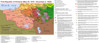
English: The First Republic of Armenia in 1918-1920. |
| Datum | |
| Izvor | Sopstveno delo |
| Autor | Accipite7 |
Licenciranje
Ja, nosilac autorskog prava nad ovim delom, objavljujem isto pod sledećom licencom:
Ova datoteka je dostupna pod licencom Creative Commons Autorstvo-Deliti pod istim uslovima 4.0 Međunarodna.
- Dozvoljeno je:
- da delite – da umnožavate, raspodeljujete i prenosite delo
- da prerađujete – da preradite delo
- Pod sledećim uslovima:
- autorstvo – Morate da date odgovarajuće zasluge, obezbedite vezu ka licenci i naznačite da li su izmene napravljene. Možete to uraditi na bilo koji razuman manir, ali ne na način koji predlaže da licencator odobrava vas ili vaše korišćenje.
- deliti pod istim uslovima – Ako izmenite, preobrazite ili dogradite ovaj materijal, morate podeliti svoje doprinose pod istom ili kompatibilnom licencom kao original.
Istorija datoteke
Kliknite na datum/vreme da biste videli tadašnju verziju datoteke.
| Datum/vreme | Minijatura | Dimenzije | Korisnik | Komentar | |
|---|---|---|---|---|---|
| trenutna | 17:13, 2. jun 2021. | | 8.192 × 3.568 (14,85 MB) | Accipite7 | for the convenience of viewing small details, the size is increased, the colors are improved |
| 10:17, 25. maj 2021. |  | 4.096 × 1.784 (3,69 MB) | Accipite7 | The border between Nahang of Shirak and Nahang of Syunik has been clarified. | |
| 11:59, 21. maj 2021. |  | 4.096 × 1.784 (3,7 MB) | Accipite7 | The temporary border between the Republic of Armenia and the Soviet republics (August 10, 1920) in the Nakhichevan county has been clarified. Added a legend marked on the map under the number 26. | |
| 10:35, 13. maj 2021. |  | 4.096 × 1.784 (3,97 MB) | Accipite7 | fixed typo | |
| 10:27, 13. maj 2021. |  | 4.096 × 1.784 (3,97 MB) | Accipite7 | The names of the types of administrative units of the former Russian Empire have been clarified: uyezd = county, okrug = district, oblast = territory, guberniya = governorate. | |
| 13:14, 12. maj 2021. |  | 4.096 × 1.784 (3,71 MB) | Accipite7 | Corrected data in the map legend regarding what is indicated on the map by numbers. Clarified the boundaries of the territories required at the Paris Peace Conference. I strongly ask the user of Culminatio not to vandalize and not return the map to the version on which he marked the line reached as a result of the Turkish offensive in 1920. Since, firstly, it is neural: Batumi, Artvin and Ardahan were under the control of the Democratic Republic of Georgia until February-March 1921. And secon... | |
| 06:13, 12. maj 2021. |  | 5.375 × 2.341 (7,18 MB) | Culminatio | Reverted to version as of 15:05, 8 May 2021 (UTC) | |
| 09:11, 11. maj 2021. |  | 4.096 × 1.784 (3,99 MB) | Accipite7 | The boundaries of the territory of the demands of the Armenian delegation in the Transcaucasus, submitted to the Paris Peace Conference of 1919, were clarified. There is no need to overload the map with the line reached by the Turkish forces in 1920, as the map already shows the results of the Armenian-Turkish war of 1920 - the border according to the Treaty of Alexandropol, December 2, 1920 | |
| 17:05, 8. maj 2021. |  | 5.375 × 2.341 (7,18 MB) | Culminatio | Additional line of the turkish advance on the northern positions during the war of 1920. Additional numbers 10,19,20,21 on the map. | |
| 12:49, 8. maj 2021. |  | 6.336 × 2.760 (2,21 MB) | Accipite7 | Improved colors. |
Upotreba datoteke
Sledeća stranica koristi ovu datoteku:
Globalna upotreba datoteke
Drugi vikiji koji koriste ovu datoteku:
- Upotreba na az.wikipedia.org
- Upotreba na be.wikipedia.org
- Upotreba na bg.wikipedia.org
- Upotreba na de.wikipedia.org
- Upotreba na el.wikipedia.org
- Upotreba na fi.wikipedia.org
- Upotreba na fr.wikipedia.org
- Upotreba na hy.wikipedia.org
- Upotreba na it.wikipedia.org
- Upotreba na nl.wikipedia.org
- Upotreba na pl.wikipedia.org
- Upotreba na pt.wikipedia.org
- Upotreba na ro.wikipedia.org
- Upotreba na ru.wikipedia.org
- Upotreba na uk.wikipedia.org
- Upotreba na zh.wikipedia.org