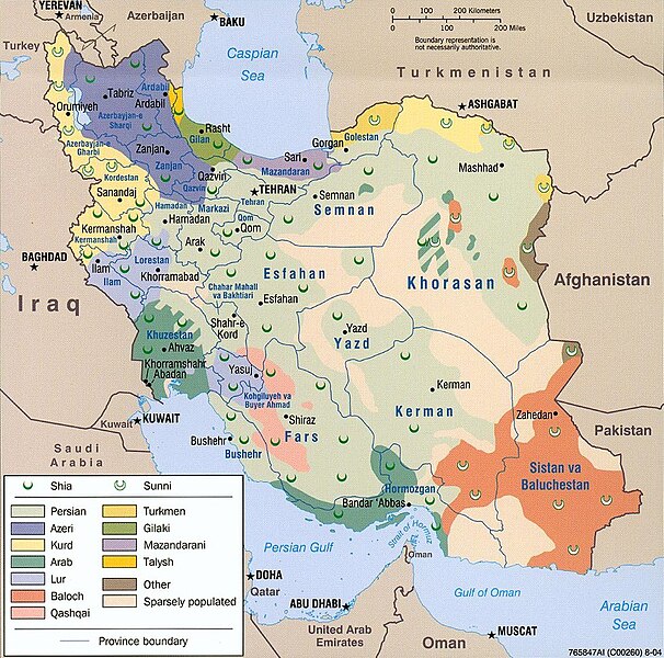
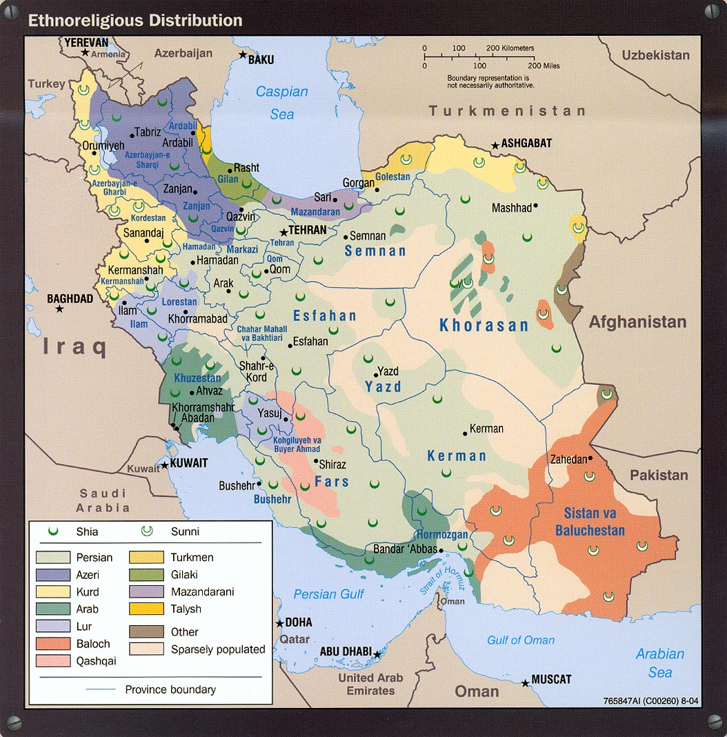
Датотека:Iran ethnoreligious distribution 2004.jpg

Veličina ovog prikaza: 606 × 600 piksela. 3 druge rezolucije: 242 × 240 piksela | 485 × 480 piksela | 980 × 970 piksela.
Originalna datoteka (980 × 970 piksela, veličina datoteke: 308 kB, MIME tip: image/jpeg)
| Ovo je datoteka sa Vikimedijine ostave. Informacije sa njene stranice sa opisom prikazane su ispod. Vikimedijina ostava je skladište slobodno licenciralnih multimedijalnih datoteka. I Vi možete da pomognete. |

Opis izmene
| Opis |
Bahasa Melayu: Iran — peta taburan etnik berdasarkan agama.
فارسی: نقشهٔ پراکنش قومی و مذهبی ایران در ۲۰۰۴ (انگلیسی) |
| Izvor | http://www.lib.utexas.edu/maps/middle_east_and_asia/iran_ethnoreligious_distribution_2004.jpg |
| Autor | Central Intelligence Agency |
| Dozvola (Ponovno korišćenje ove datoteke) |
Above the list of maps available for download, the web site has the text: The following maps were produced by the U.S. Central Intelligence Agency, unless otherwise indicated. There is no indication that this map was not produced by the CIA. |
Licenciranje
| This image is a work of a Central Intelligence Agency employee, taken or made as part of that person's official duties. As a Work of the United States Government, this image or media is in the public domain in the United States.
|

|
Istorija datoteke
Kliknite na datum/vreme da biste videli tadašnju verziju datoteke.
| Datum/vreme | Minijatura | Dimenzije | Korisnik | Komentar | |
|---|---|---|---|---|---|
| trenutna | 19:38, 28. jul 2021. | | 980 × 970 (308 kB) | GPinkerton | Reverted to version as of 20:33, 13 December 2005 (UTC) Back to the original image, yet again. See https://lccn.loc.gov/2005634048 for the original 2004 CIA "Iran country profile" info-graphic of which this map is a part. |
| 20:24, 23. februar 2015. |  | 980 × 970 (419 kB) | Lantad | original map is not correct | |
| 04:05, 23. decembar 2014. |  | 980 × 970 (308 kB) | Abrahamic Faiths | I assume that User:HistoryofIran reverted to this version by mistake, the lurs are not this widely spread, keep consistent with this map | |
| 16:02, 8. oktobar 2014. |  | 980 × 970 (419 kB) | HistoryofIran | Removed vandalism by puppet account. | |
| 16:07, 28. septembar 2014. |  | 980 × 970 (419 kB) | Apiculate | You are going to say half of lorestan province are not lur ? | |
| 16:06, 28. septembar 2014. |  | 980 × 970 (419 kB) | Apiculate | You are going to say half of lorestan province are not lur ? | |
| 20:57, 14. septembar 2014. |  | 980 × 970 (308 kB) | HistoryofIran | Removed disprutive edit; that doesn't make any sense. | |
| 00:25, 12. septembar 2014. |  | 980 × 970 (419 kB) | Apiculate | in ethnologue, Bakhtiari considered a dialect of luri language ,Source: http://www.ethnologue.com/language/bqi/view/***EDITION*** | |
| 18:12, 15. avgust 2014. |  | 980 × 970 (308 kB) | HistoryofIran | Removed disprutive edit. | |
| 12:56, 7. avgust 2014. |  | 980 × 970 (419 kB) | Apiculate | Reverted to version as of 06:16, 6 June 2014 |
Upotreba datoteke
Sledeća stranica koristi ovu datoteku:
Globalna upotreba datoteke
Drugi vikiji koji koriste ovu datoteku:
- Upotreba na af.wikipedia.org
- Upotreba na av.wikipedia.org
- Upotreba na ba.wikipedia.org
- Upotreba na cs.wikipedia.org
- Upotreba na de.wikipedia.org
- Upotreba na en.wikipedia.org
- Upotreba na en.wikinews.org
- Upotreba na fa.wikipedia.org
- Upotreba na he.wikipedia.org
- Upotreba na hr.wikipedia.org
- Upotreba na hu.wikipedia.org
- Upotreba na it.wikipedia.org
- Upotreba na ka.wikipedia.org
- Upotreba na nl.wikipedia.org
- Upotreba na nn.wikipedia.org
- Upotreba na no.wikipedia.org
- Upotreba na pt.wikipedia.org
- Upotreba na ru.wikipedia.org
- Upotreba na sh.wikipedia.org
- Upotreba na simple.wikipedia.org
- Upotreba na tg.wikipedia.org
- Upotreba na tr.wikipedia.org
- Upotreba na tt.wikipedia.org
- Upotreba na zh.wikipedia.org