Датотека:Old Harbor Alaska aerial view.jpg

Veličina ovog prikaza: 633 × 599 piksela. 5 drugih rezolucija: 254 × 240 piksela | 507 × 480 piksela | 811 × 768 piksela | 1.082 × 1.024 piksela | 1.500 × 1.420 piksela.
Originalna datoteka (1.500 × 1.420 piksela, veličina datoteke: 747 kB, MIME tip: image/jpeg)
| Ovo je datoteka sa Vikimedijine ostave. Informacije sa njene stranice sa opisom prikazane su ispod. Vikimedijina ostava je skladište slobodno licenciralnih multimedijalnih datoteka. I Vi možete da pomognete. |
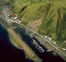
| Opis | Aerial view of Old Harbor, Kodiak Island, Alaska, USA. | |||
| Lokacija | Old Harbor, Kodiak Island, Alaska, USA 57°11′50″N 153°18′28″W / 57.1972°N 153.30778°W |
|||
| Datum | not specified | |||
| Izvor |
U.S. Army Corps of Engineers Digital Visual Library Image page Image description page Digital Visual Library home page |
|||
| Autor | U.S. Army Corps of Engineers, photographer unknown | |||
| Dozvola (Ponovno korišćenje ove datoteke) |
|
Istorija datoteke
Kliknite na datum/vreme da biste videli tadašnju verziju datoteke.
| Datum/vreme | Minijatura | Dimenzije | Korisnik | Komentar | |
|---|---|---|---|---|---|
| trenutna | 07:08, 19. mart 2007. | | 1.500 × 1.420 (747 kB) | DanMS | {{Information | Description = Aerial view of Old Harbor, Kodiak Island, Alaska, USA. | Source = U.S. Army Corps of Engineers Digital Visual Library<br />[http://images.usace.army.mil/images/Hires/4414-15.Jpg Image page]<br />[http://images.usace.army |
Upotreba datoteke
Sledeća stranica koristi ovu datoteku:
Globalna upotreba datoteke
Drugi vikiji koji koriste ovu datoteku:
- Upotreba na ar.wikipedia.org
- Upotreba na arz.wikipedia.org
- Upotreba na azb.wikipedia.org
- Upotreba na ca.wikipedia.org
- Upotreba na ceb.wikipedia.org
- Upotreba na ce.wikipedia.org
- Upotreba na ch.wikipedia.org
- Upotreba na en.wikipedia.org
- Upotreba na es.wikipedia.org
- Upotreba na eu.wikipedia.org
- Upotreba na fa.wikipedia.org
- Upotreba na fr.wikipedia.org
- Upotreba na ht.wikipedia.org
- Upotreba na it.wikipedia.org
- Upotreba na lld.wikipedia.org
- Upotreba na mg.wikipedia.org
- Upotreba na ml.wikipedia.org
- Upotreba na mrj.wikipedia.org
- Upotreba na nl.wikipedia.org
- Upotreba na no.wikipedia.org
- Upotreba na pl.wikipedia.org
- Upotreba na pt.wikipedia.org
- Upotreba na ru.wikipedia.org
- Upotreba na sh.wikipedia.org
- Upotreba na tly.wikipedia.org
- Upotreba na tr.wikipedia.org
- Upotreba na tt.wikipedia.org
- Upotreba na uk.wikipedia.org
- Upotreba na uz.wikipedia.org
- Upotreba na www.wikidata.org
- Upotreba na zh-min-nan.wikipedia.org