Датотека:Empire akkad.svg

Оригинална датотека (SVG датотека, номинално 1.475 × 1.149 пиксела, величина: 2,34 MB)
| Ово је датотека са Викимедијине оставе. Информације са њене странице са описом приказане су испод. Викимедијина остава је складиште слободно лиценциралних мултимедијалних датотека. И Ви можете да помогнете. |
Опис измене

|
Ова SVG датотека користи уграђени текст који се може лако превести на ваш језик. Више детаља. За SVG слике можете користити [toolforge:svgtranslate/File:Empire_akkad.svglink ову страницу] како бисте је превели на ваш језик. |
| Опис |
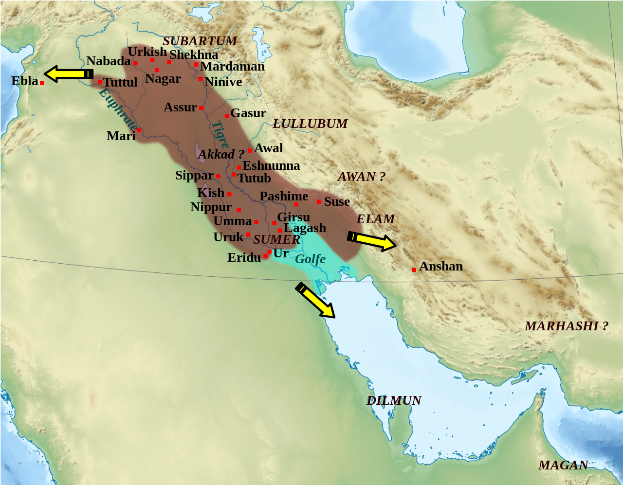
English: Mapa que mostra l'extensió aproximada de l'imperi Accadi durant el regnat de Narâm-Sîn (2254-2218 a.C. en la cronologia breu). Français : Carte de l'extension approximative de l'empire d'Akkad sous le règne de Narâm-Sîn (2254-2218 av. J.-C. selon la chronologie moyenne), et des directions des campagnes militaires extérieures. Sources : B. Lafont et M. Sauvage dans M. Sauvage (dir.), Atlas historique du Proche-Orient ancien, Paris, Les Belles Lettres, 2020, p. 70 ; P. Michalowski, « The Kingdom of Akkad in Contact with the World », dans The Oxford History of the Ancient Near East, Volume 1: From the Beginnings to Old Kingdom Egypt and the Dynasty of Akkad, New York, Oxford University Press, 2020, p. 688 fig. 10.1. |
| Датум | (UTC) |
| Извор | |
| Аутор |
|
| Остале верзије |
File:Empire akkad.svg has 2 translations.
Other related versions: []
|


| Положај камере | | Ова и друге слике снимљене у близини на: OpenStreetMap |
|---|
|
|
Ова SVG датотека користи уграђени текст који се може лако превести на ваш језик. Више детаља. За SVG слике можете користити [toolforge:svgtranslate/File:Empire_akkad.svglink ову страницу] како бисте је превели на ваш језик. |
This file is translated using SVG For most Wikipedia projects, you can embed the file normally (without a To translate the text into your language, you can use the SVG Translate tool. Alternatively, you can download the file to your computer, add your translations using whatever software you're familiar with, and re-upload it with the same name. You will find help in Graphics Lab if you're not sure how to do this. |
| Ово је ретуширана слика, што значи да је дигитално измењена у односу на своју изворну верзију. Измене: Ajout des villes, du contour approximatif de l'empire.. Изворна верзија се може видети овде: Middle East topographic map-blank.svg. Измене је направио: Zunkir.
|
Лиценцирање
- Дозвољено је:
- да делите – да умножавате, расподељујете и преносите дело
- да прерађујете – да прерадите дело
- Под следећим условима:
- ауторство – Морате да дате одговарајуће заслуге, обезбедите везу ка лиценци и назначите да ли су измене направљене. Можете то урадити на било који разуман манир, али не на начин који предлаже да лиценцатор одобрава вас или ваше коришћење.
- делити под истим условима – Ако измените, преобразите или доградите овај материјал, морате поделити своје доприносе под истом или компатибилном лиценцом као оригинал.

|
Дата је дозвола да се копира, дистрибуира и/или мења овај документ под условима ГНУ-ове лиценце за слободну документацију, верзије 1.2 или било које новије верзије коју објави Задужбина за слободни софтвер; без непроменљивих одељака и без текста на насловној и задњој страни. Текст лиценце можете прочитати овде. |
Првобитан дневник отпремања
This image is a derivative work of the following images:
- File:Middle_East_topographic_map-blank.svg licensed with Cc-by-sa-3.0,2.5,2.0,1.0, GFDL
- 2010-11-03T17:52:56Z Sémhur 3097x1938 (10510751 Bytes) == {{int:filedesc}} == {{Information |Description={{Multilingual description |en= Blank physical map of the [[:en:Middle East|Middle East]] |fr= Carte physique vierge du [[:fr:Moyen-Orient|Moyen-Orient]]. }} |Source={{own}}.
Uploaded with derivativeFX
Историја датотеке
Кликните на датум/време да бисте видели тадашњу верзију датотеке.
| Датум/време | Минијатура | Димензије | Корисник | Коментар | |
|---|---|---|---|---|---|
| тренутна | 03:21, 19. фебруар 2024. | | 1.475 × 1.149 (2,34 MB) | Manlleus | File uploaded using svgtranslate tool (https://svgtranslate.toolforge.org/). Added translation for ca. |
| 16:42, 6. мај 2023. |  | 1.475 × 1.149 (2,32 MB) | Zunkir | + Awal | |
| 19:18, 11. март 2023. |  | 1.475 × 1.149 (2,32 MB) | Zunkir | taille police | |
| 18:58, 11. март 2023. |  | 1.475 × 1.149 (2,32 MB) | Zunkir | contours, villes | |
| 13:49, 29. октобар 2011. |  | 1.475 × 1.149 (2,33 MB) | Zunkir | Police. | |
| 22:32, 28. октобар 2011. |  | 1.475 × 1.149 (2,32 MB) | Zunkir | Reverted to version as of 10:06, 7 January 2011 | |
| 22:31, 28. октобар 2011. |  | 1.475 × 1.149 (2,33 MB) | Zunkir | Police. | |
| 12:06, 7. јануар 2011. |  | 1.475 × 1.149 (2,32 MB) | Sémhur | Remove coloured boxes | |
| 00:31, 12. новембар 2010. |  | 1.475 × 1.149 (2,33 MB) | Zunkir | New new try | |
| 00:13, 12. новембар 2010. |  | 1.475 × 1.149 (2,33 MB) | Zunkir | Again ... |
Употреба датотеке
Следећа страница користи ову датотеку:
Глобална употреба датотеке
Други викији који користе ову датотеку:
- Употреба на af.wikipedia.org
- Употреба на ar.wikipedia.org
- Употреба на arz.wikipedia.org
- Употреба на ast.wikipedia.org
- Употреба на azb.wikipedia.org
- Употреба на az.wikipedia.org
- Употреба на bg.wikipedia.org
- Употреба на bn.wikipedia.org
- Употреба на br.wikipedia.org
- Употреба на bs.wikipedia.org
- Употреба на ca.wikipedia.org
- Употреба на ckb.wikipedia.org
- Употреба на cs.wikipedia.org
- Употреба на da.wikipedia.org
- Употреба на el.wikipedia.org
- Употреба на en.wikipedia.org
- Akkadian Empire
- Shar-Kali-Sharri
- Gutian rule in Mesopotamia
- Naram-Sin of Akkad
- List of conflicts in Asia
- History of Mesopotamia
- Middle Eastern empires
- Rimush
- User:RekonDog/Sandbox
- Sargon of Akkad
- User:RekonDog/sandbox
- Armi (Syria)
- Akkad (city)
- User:History of Persia/sandbox
- User:Monochrome Monitor/Under Construction
- Early Assyrian period
- King of the Universe
- King of Sumer and Akkad
- Abalgamash
- User:SomeGuyWhoRandomlyEdits/History of Sumer
Још глобалног коришћења ове датотеке.