Датотека:Fort-Jefferson Dry-Tortugas.jpg

Оригинална датотека (1.200 × 796 пиксела, величина датотеке: 1,03 MB, MIME тип: image/jpeg)
| Ово је датотека са Викимедијине оставе. Информације са њене странице са описом приказане су испод. Викимедијина остава је складиште слободно лиценциралних мултимедијалних датотека. И Ви можете да помогнете. |
|
This is an image of a place or building that is listed on the National Register of Historic Places in the United States of America. Its reference number is 70000069. |
|
Опис измене
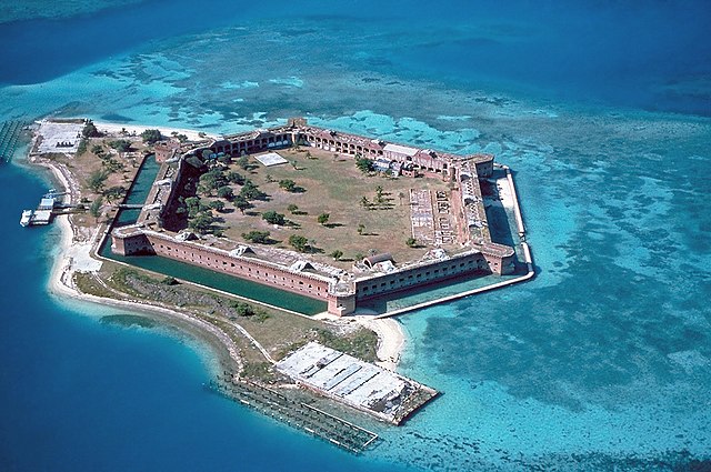
| Опис |
Fort Jefferson at the Dry Tortugas. The clear waters in shallow areas surrounding the fort, seen easily in the photo, are popular for snorkeling and scuba diving. Visible on the right side of the image is a breach of the sea wall caused by the direct strike of Hurricane Charley in August 2004.
|
||||
| Датум | |||||
| Извор | U.S. National Park Service [1]; English Wikipedia, original upload 2 March 2005 by Brian0918 | ||||
| Аутор | U.S. National Park Service |
Лиценцирање
| This image or media file contains material based on a work of a National Park Service employee, created as part of that person's official duties. As a work of the U.S. federal government, such work is in the public domain in the United States. See the NPS website and NPS copyright policy for more information. |

Историја датотеке
Кликните на датум/време да бисте видели тадашњу верзију датотеке.
| Датум/време | Минијатура | Димензије | Корисник | Коментар | |
|---|---|---|---|---|---|
| тренутна | 17:07, 22. април 2017. | | 1.200 × 796 (1,03 MB) | Bubba73 | Color correction and remove some haze |
| 19:57, 8. децембар 2006. |  | 1.200 × 796 (1,01 MB) | Holly Cheng | Reverted to earlier revision | |
| 07:40, 8. децембар 2006. |  | 3.072 × 2.048 (4,89 MB) | Keeleysam | ||
| 09:50, 16. септембар 2005. |  | 1.200 × 796 (1,01 MB) | Saperaud~commonswiki | Fort Jefferson at the Dry Tortugas. As seen easily in the photo, the clear waters in shallow areas surrounding the fort are popular for snorkeling and SCUBA. Visible on the right side of the image is a breach of the sea wall caused by the direct strik |
Употреба датотеке
2 следеће странице користе ову датотеку:
Глобална употреба датотеке
Други викији који користе ову датотеку:
- Употреба на ang.wikipedia.org
- Употреба на ar.wikipedia.org
- Употреба на ast.wikipedia.org
- Употреба на az.wikipedia.org
- Употреба на ban.wikipedia.org
- Употреба на bg.wikipedia.org
- Употреба на ca.wikipedia.org
- Употреба на ceb.wikipedia.org
- Употреба на cs.wikipedia.org
- Употреба на da.wikipedia.org
- Употреба на de.wikipedia.org
- Употреба на de.wikivoyage.org
- Употреба на el.wikipedia.org
- Употреба на en.wikipedia.org
- Hexagon
- Moat
- Dry Tortugas National Park
- Wikipedia:Featured picture candidates/Fort-Jefferson Dry-Tortugas.jpg
- Wikipedia:Featured picture candidates/March-2005
- User talk:Brian0918/Archive 03
- Wikipedia:Picture of the day/April 2, 2005
- Wikipedia:POTD/April 2, 2005
- Wikipedia:Picture of the day/April 2005
- Wikipedia:Featured pictures thumbs/01
- User:Witan
- User talk:Brian0918/Featured gallery
- Maritime history of Florida
- Wikipedia:Featured picture candidates/delist/2006
Још глобалног коришћења ове датотеке.