Датотека:Mount Mazama eruption timeline.PNG
Оригинална датотека (250 × 841 пиксела, величина датотеке: 187 kB, MIME тип: image/png)
| Ово је датотека са Викимедијине оставе. Информације са њене странице са описом приказане су испод. Викимедијина остава је складиште слободно лиценциралних мултимедијалних датотека. И Ви можете да помогнете. |
Опис измене
| Опис |
|
| Извор | http://pubs.usgs.gov/fs/2002/fs092-02/ (saved as PNG) |
| Аутор | U.S. GEOLOGICAL SURVEY and the NATIONAL PARK SERVICE |
| Остале верзије |
    |

|
Ова geology слика требало би да буду поново израђене као векторска графика у SVG формату. Тиме се остварује неколико предности. Више информација потражите на Commons:Media for cleanup. Ако је ова слика већ доступна у SVG формату, отпремите је. Након отпремања датотеке, овај шаблон замените шаблоном {{vector version available|new image name.svg}}.
|
Лиценцирање
This image is in the public domain in the United States because it only contains materials that originally came from the United States Geological Survey, an agency of the United States Department of the Interior. For more information, see the official USGS copyright policy.
|
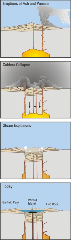
Crater Lake is an example, it is located in Oregen and was made from a valcano, making a caldera.
Историја датотеке
Кликните на датум/време да бисте видели тадашњу верзију датотеке.
| Датум/време | Минијатура | Димензије | Корисник | Коментар | |
|---|---|---|---|---|---|
| тренутна | 07:24, 29. март 2006. | 250 × 841 (187 kB) | Jkelly | Source: http://pubs.usgs.gov/fs/2002/fs092-02/ (saved as PNG) Author: U.S. GEOLOGICAL SURVEY and the NATIONAL PARK SERVICE Description: <blockquote>Cataclysmic eruption to present. Eruptions of ash and pumice: The cataclysmic eruption started from a ve |
Употреба датотеке
2 следеће странице користе ову датотеку:
Глобална употреба датотеке
Други викији који користе ову датотеку:
- Употреба на af.wikipedia.org
- Употреба на an.wikipedia.org
- Употреба на ar.wikipedia.org
- Употреба на ast.wikipedia.org
- Употреба на br.wikipedia.org
- Употреба на ce.wikipedia.org
- Употреба на cy.wikipedia.org
- Употреба на de.wikipedia.org
- Употреба на en.wikipedia.org
- Употреба на en.wikiversity.org
- Употреба на eo.wikipedia.org
- Употреба на es.wikipedia.org
- Употреба на fa.wikipedia.org
- Употреба на fi.wikipedia.org
- Употреба на fr.wikipedia.org
- Употреба на id.wikipedia.org
- Употреба на it.wikipedia.org
- Употреба на ja.wikipedia.org
- Употреба на ko.wikipedia.org
- Употреба на lv.wikipedia.org
- Употреба на min.wikipedia.org
- Употреба на mk.wikipedia.org
- Употреба на ml.wikipedia.org
- Употреба на pt.wikipedia.org
- Употреба на ru.wikipedia.org
- Употреба на simple.wikipedia.org
- Употреба на sk.wikipedia.org
- Употреба на su.wikipedia.org
- Употреба на vi.wikipedia.org
- Употреба на www.wikidata.org