Датотека:Albania kosovo macedonia 6 8 century.png
Величина овог приказа: 370 × 600 пиксела. 2 друге резолуције: 148 × 240 пиксела | 597 × 968 пиксела.
Оригинална датотека (597 × 968 пиксела, величина датотеке: 55 kB, MIME тип: image/png)
| Ово је датотека са Викимедијине оставе. Информације са њене странице са описом приказане су испод. Викимедијина остава је складиште слободно лиценциралних мултимедијалних датотека. И Ви можете да помогнете. |
Опис измене
| Опис |
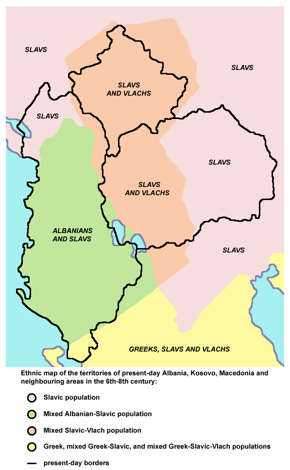
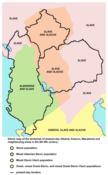
English: Ethnic map of the territories of present-day Albania, Kosovo, Macedonia and neighbouring areas in the 6th-8th century (according to the historical atlas for schools, published in Belgrade in 1970, representing a view of Yugoslav historians from that time). |
| Извор | Сопствено дело |
| Аутор | PANONIAN |
Лиценцирање
| Ја, творац овог дела, предајем га у јавно власништво. Ово се односи на цео свет. У неким земљама, ово није законски могуће; у том случају: Ја, творац овог дела дозвољавам свакоме да користи ово дело за било коју намену, без било каквих услова, осим услова које намеће закон. |
References
Main reference:
- Created according to the historical map from this history atlas: "Školski istorijski atlas, Zavod za izdavanje udžbenika SR Srbije, Beograd, 1970."
Secondary references (with similar maps):
- The Times - Atlas Svjetske Povijesti, Dopunjeno izdanje za Jugoslaviju, Cankarjeva založba, Ljubljana, 1986. - this is Yugoslav (Serbo-Croatian) edition of this original source: The Times Atlas of World History, Times Books Limited, London, 1984. (in Yugoslav version from 1986 there is similar map on page number 298)
- Denis Šehić - Demir Šehić, Istorijski atlas Sveta, Beograd, 2007. (similar map is published on page number 29)
- Istorijski atlas, Geokarta, Beograd, 1999. (similar map is published on page number 33)
- The former Yugoslavia's diverse peoples: a reference sourcebook By Matjaž Klemenčič, Mitja Žagar: https://books.google.com/books?id=ORSMBFwjAKcC&pg=PA3&lpg=PA5&vq=maps&output=html (a source with similar map published on page number 3)
- Here is an external link with similar map: http://www.camo.ch/illiricum7.htm archive copy at the Wayback Machine
Историја датотеке
Кликните на датум/време да бисте видели тадашњу верзију датотеке.
| Датум/време | Минијатура | Димензије | Корисник | Коментар | |
|---|---|---|---|---|---|
| тренутна | 22:27, 21. септембар 2013. | | 597 × 968 (55 kB) | PANONIAN | aesthetics |
| 20:56, 7. фебруар 2010. |  | 598 × 964 (55 kB) | PANONIAN | {{Information |Description={{en|1=Ethnic map of the territories of present-day Albania, Kosovo, Macedonia and neighbouring areas in the 6th-8th century.}} |Source={{own}} |Author=PANONIAN |Date= |Permission= |other_versions= }} |
Употреба датотеке
2 следеће странице користе ову датотеку:
Глобална употреба датотеке
Други викији који користе ову датотеку:
- Употреба на hr.wikipedia.org
- Употреба на hu.wikipedia.org
- Употреба на mk.wikipedia.org
- Употреба на pl.wikipedia.org