Датотека:Cape Cod Landsat 7.jpg

Величина овог приказа: 676 × 600 пиксела. 5 других резолуција: 271 × 240 пиксела | 541 × 480 пиксела | 866 × 768 пиксела | 1.154 × 1.024 пиксела | 2.418 × 2.145 пиксела.
Оригинална датотека (2.418 × 2.145 пиксела, величина датотеке: 1,07 MB, MIME тип: image/jpeg)
| Ово је датотека са Викимедијине оставе. Информације са њене странице са описом приказане су испод. Викимедијина остава је складиште слободно лиценциралних мултимедијалних датотека. И Ви можете да помогнете. |
| Опис |
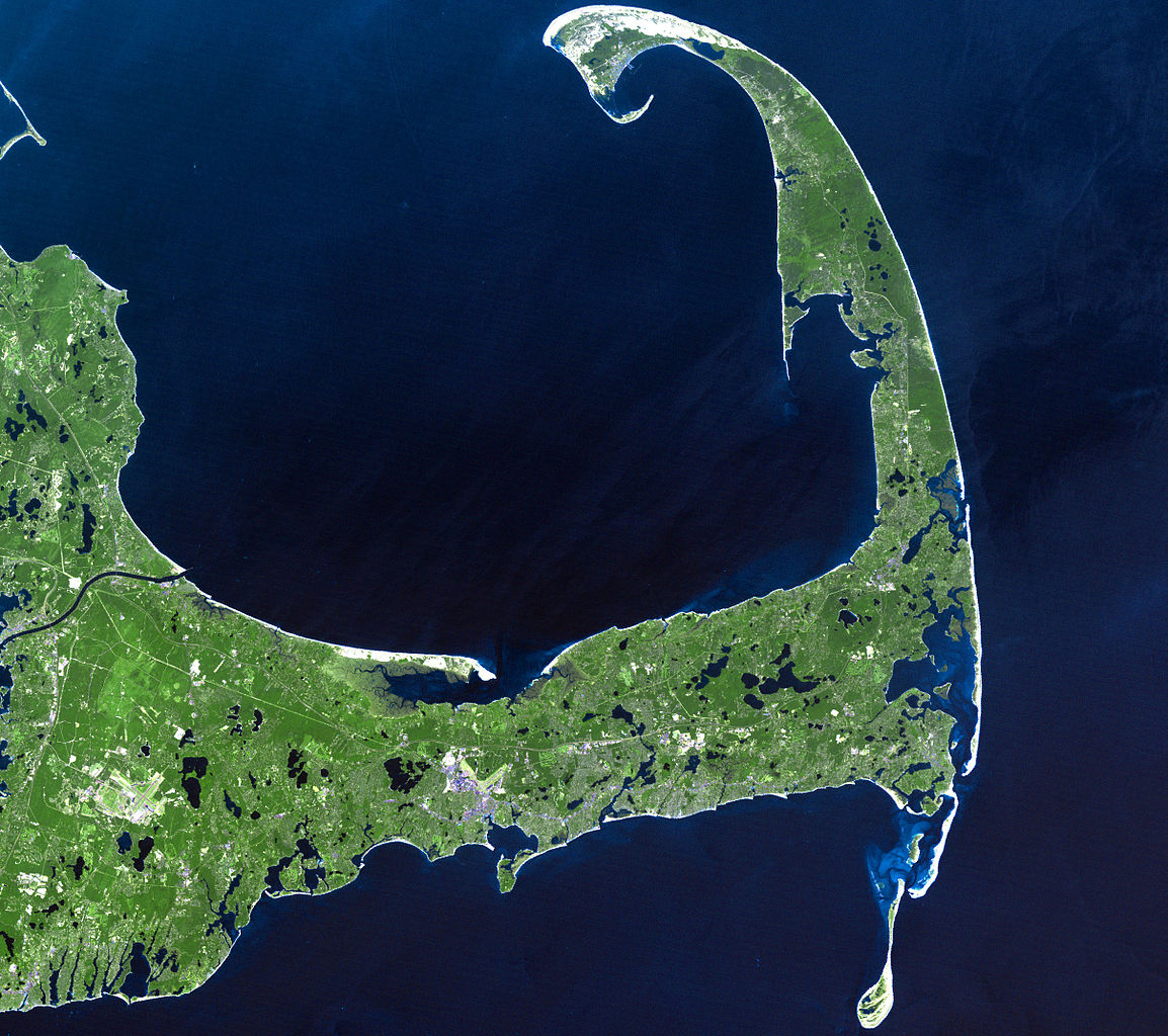
English: In easternmost Massachusetts, Cape Cod juts dramatically out into the Atlantic Ocean. The 65-mile peninsula has Cape Cod Bay to its north, the Nantucket Sound to its south and the Atlantic Ocean to its east. It is the world’s largest glacially formed peninsula; a remnant landscape left by the retreating Laurentide Ice Sheet.
The outer shore of the cape, from Long Point to south of Pleasant Bay, was designated as the Cape Cod National Seashore in August of 1961. The National Seashore encompasses over 44,000 acres of land, which includes marine, estuarine, and freshwater ecosystems. This Landsat 7 image was acquired on June 22, 2002. The pseudo-natural colour image, is a composite of ETM+ bands 7, 5, and 3. Cape Cod is found on Landsat WRS-2 Path 11 Row 31. |
| Датум |
22. јун 2002. |
| Извор |
http://landsat.gsfc.nasa.gov/images/lg_jpg/f0006_06.22.02.jpg (http://landsat.gsfc.nasa.gov/images/archive/f0006.html) |
| Аутор |
NASA/Landsat 7. Original uploader was Ktr101 at en.wikipedia |
Лиценцирање
| Ова датотека је у јавном власништву зато што је њен аутор НАСА. НАСА-а политика ауторских права наводи „Материјали НАСА-е нису заштићени ауторским правима осим ако није другачије наведено“. (Погледајте Template:PD-USGov, NASA copyright policy page или JPL Image Use Policy.) | ||
 |
Упозорења:
|
This image is in the public domain in the United States because it only contains materials that originally came from the United States Geological Survey, an agency of the United States Department of the Interior. For more information, see the official USGS copyright policy.
|
Првобитан дневник отпремања
Оригиналан опис странице је био овде. Сва наведена корисничка имена воде на en.wikipedia.
- 2008-06-14 02:08 Ktr101 2418×2145× (1120814 bytes) Cape Cod from a Landsat 7 image in 2002. Source:http://landsat.gsfc.nasa.gov/images/archive/f0006.html
Историја датотеке
Кликните на датум/време да бисте видели тадашњу верзију датотеке.
| Датум/време | Минијатура | Димензије | Корисник | Коментар | |
|---|---|---|---|---|---|
| тренутна | 18:13, 9. август 2009. | | 2.418 × 2.145 (1,07 MB) | Transatracurium | {{Information |Description={{en| In easternmost Massachusetts, Cape Cod juts dramatically out into the Atlantic Ocean. The 65-mile peninsula has Cape Cod Bay to its north, the Nantucket Sound to its south and the Atlantic Ocean to its east. It is the worl |
Употреба датотеке
Следећа страница користи ову датотеку:
Глобална употреба датотеке
Други викији који користе ову датотеку:
- Употреба на ca.wikipedia.org
- Употреба на de.wikipedia.org
- Употреба на en.wikipedia.org
- Cape Cod
- User:Dchurbuck
- User:Cape cod naturalist
- User:Clariosophic
- User:Seduisant
- User:Quissett
- Attack on Orleans
- User:Lrsears
- Wikipedia:WikiProject Cape Cod and the Islands
- Template:User WikiProject Cape Cod and the Islands
- User:Ktr101/Userboxes
- User:Grolltech
- User:Happyandrew1994
- Wikipedia:Userboxes/WikiProjects/Regional/03
- Shields (album)
- Wikipedia:Userboxes/WikiProjects/alphabetical/06
- Category:Wikipedians interested in Cape Cod and the Islands
- User:M V D H P
- Употреба на he.wikipedia.org
- Употреба на mk.wikipedia.org
- Употреба на sk.wikipedia.org
- Употреба на www.wikidata.org