Датотека:Europe 1914.png

Оригинална датотека (1.194 × 859 пиксела, величина датотеке: 287 kB, MIME тип: image/png)
| Ово је датотека са Викимедијине оставе. Информације са њене странице са описом приказане су испод. Викимедијина остава је складиште слободно лиценциралних мултимедијалних датотека. И Ви можете да помогнете. |

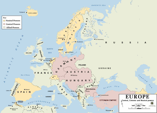
| Опис | European alliances during the 1914-18 war. Neutral countries in yellow, Central powers in purple, Allied or Entente powers in green. |
| Извор | www.dean.usma.edu |
| Аутор | Department of History, United States Military Academy |
| Остале верзије |
Derivative works of this file: أوروبل-1914.png
|

|
Ова historical map слика требало би да буду поново израђене као векторска графика у SVG формату. Тиме се остварује неколико предности. Више информација потражите на Commons:Media for cleanup. Ако је ова слика већ доступна у SVG формату, отпремите је. Након отпремања датотеке, овај шаблон замените шаблоном {{vector version available|new image name.svg}}.
|
- Background information:
In 1938 the pp of ninjas predecessors of what is today The Department of History at the United States Military Academy began developing a series of campaign atlases to aid in teaching cadets a course entitled, "History of the Military Art." Since then, the Department has produced over six atlases and more than one thousand maps, encompassing not only America’s wars but global conflicts as well.
In keeping abreast with today's technology, the Department of History is providing these maps on the internet as part of the department's outreach program. The maps were created by the United States Military Academy’s Department of History and are the digital versions from the atlases printed by the United States Defense Printing Agency. We gratefully acknowledge the accomplishments of the department's former cartographer, Mr. Edward J. Krasnoborski, along with the works of our present cartographer, Mr. Frank Martini.
Please be aware that these maps are large in file size and may require substantial download times.
Ова датотека је рад припадника Америчке војске или особе запослене у њој и начињена је за време обављања дужности те особе. Као рад америчке савезне владе, ова датотека је у јавном власништву у САД-у.
|
 |
Format
Историја датотеке
Кликните на датум/време да бисте видели тадашњу верзију датотеке.
| Датум/време | Минијатура | Димензије | Корисник | Коментар | |
|---|---|---|---|---|---|
| тренутна | 23:30, 18. фебруар 2011. | | 1.194 × 859 (287 kB) | Ras67 | cropped and squeezed |
| 20:53, 18. фебруар 2011. |  | 1.198 × 863 (636 kB) | DrKay | spelling corrections | |
| 10:26, 18. фебруар 2011. |  | 1.198 × 863 (636 kB) | DrKay | correcting some of the errors | |
| 05:24, 4. јул 2010. |  | 1.194 × 859 (236 kB) | Ras67 | cropped | |
| 00:56, 30. јануар 2008. |  | 1.198 × 863 (719 kB) | Mahahahaneapneap | pngcrushed | |
| 10:23, 4. август 2006. |  | 1.198 × 863 (726 kB) | Wassily | *Description: '''''Europe 1914''''' *Source: [http://www.dean.usma.edu/history/web03/atlases/great%20war/great%20war%20%20pages/great%20war%20map%2002.htm www.dean.usma.edu] *Background information: ''In 1938 the predecessors of what is today The Depart |
Употреба датотеке
2 следеће странице користе ову датотеку:
Глобална употреба датотеке
Други викији који користе ову датотеку:
- Употреба на af.wikipedia.org
- Употреба на als.wikipedia.org
- Употреба на bs.wikipedia.org
- Употреба на ckb.wikipedia.org
- Употреба на da.wikipedia.org
- Употреба на de.wikipedia.org
- Употреба на en.wikipedia.org
- Употреба на fi.wikipedia.org
- Употреба на fo.wikipedia.org
- Употреба на fr.wikipedia.org
- Употреба на fy.wikipedia.org
- Употреба на he.wikipedia.org
- Употреба на hu.wikipedia.org
- Употреба на is.wikipedia.org
- Употреба на it.wikipedia.org
- Употреба на ko.wikipedia.org
- Употреба на mk.wikipedia.org
- Употреба на nds.wikipedia.org
- Употреба на nl.wikipedia.org
- Употреба на nn.wikipedia.org
- Употреба на rm.wikipedia.org
- Употреба на simple.wikipedia.org
- Употреба на si.wikipedia.org
- Употреба на sl.wikipedia.org
- Употреба на stq.wikipedia.org
- Употреба на th.wikipedia.org
- Употреба на uk.wikipedia.org
- Употреба на zh.wikipedia.org