Датотека:Kilauea-falsecolor.jpg

Оригинална датотека (1.440 × 862 пиксела, величина датотеке: 137 kB, MIME тип: image/jpeg)
| Ово је датотека са Викимедијине оставе. Информације са њене странице са описом приказане су испод. Викимедијина остава је складиште слободно лиценциралних мултимедијалних датотека. И Ви можете да помогнете. |
Опис измене
| Опис |
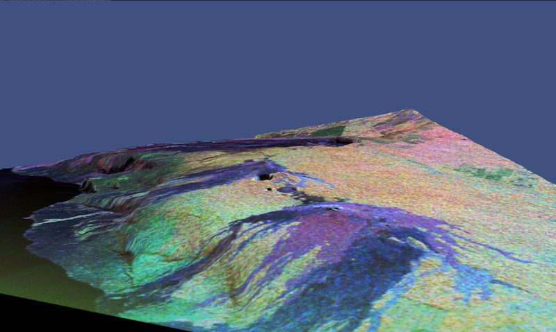
NASA space-radar false-color image of Kilauea, Hawaii. This is a three-dimensional perspective view of a false-color image of the eastern part of the Big Island of Hawaii. It was produced using all three radar frequencies -- X-band, C-band and L-band -- from the Spaceborne Imaging Radar-C/X-Band Synthetic Aperture Radar (SIR-C/X-SAR) flying on the space shuttle Endeavour, overlaid on a U.S. Geological Survey digital elevation map. Visible in the center of the image in blue are the summit crater (Kilauea Caldera) which contains the smaller Halemaumau Crater, and the line of collapse craters below them that form the Chain of Craters Road. The image was acquired on April 12, 1994 during orbit 52 of the space shuttle. The area shown is approximately 34 by 57 kilometers (21 by 35 miles) with the top of the image pointing toward northwest. The image is centered at about 155.25 degrees west longitude and 19.5 degrees north latitude. The false colors are created by displaying three radar channels of different frequency. Red areas correspond to high backscatter at L-HV polarization, while green areas exhibit high backscatter at C-HV polarization. Finally, blue shows high return at X-VV polarization. Using this color scheme, the rain forest appears bright on the image, while the green areas correspond to lower vegetation. The lava flows have different colors depending on their types and are easily recognizable due to their shapes. |
||||||||
| Датум | |||||||||
| Извор | http://photojournal.jpl.nasa.gov/catalog/PIA01717 | ||||||||
| Аутор | NASA/JPL Caltech | ||||||||
| Дозвола (Поновно коришћење ове датотеке) |
|

Историја датотеке
Кликните на датум/време да бисте видели тадашњу верзију датотеке.
| Датум/време | Минијатура | Димензије | Корисник | Коментар | |
|---|---|---|---|---|---|
| тренутна | 17:37, 28. новембар 2005. | | 1.440 × 862 (137 kB) | Hike395 | NASA space-radar false-color image of Kilauea, Hawaii. Source URL: http://photojournal.jpl.nasa.gov/catalog/PIA01717 Courtesy NASA/JPL Caltech Source caption: This is a three-dimensional perspective view of a false-color image of the eastern part of th |
Употреба датотеке
Следећа страница користи ову датотеку:
Глобална употреба датотеке
Други викији који користе ову датотеку: