Датотека:Mountain Fork Bridge.jpg

Величина овог приказа: 471 × 599 пиксела. 6 других резолуција: 189 × 240 пиксела | 377 × 480 пиксела | 604 × 768 пиксела | 805 × 1.024 пиксела | 1.611 × 2.048 пиксела | 3.691 × 4.693 пиксела.
Оригинална датотека (3.691 × 4.693 пиксела, величина датотеке: 1,61 MB, MIME тип: image/jpeg)
| Ово је датотека са Викимедијине оставе. Информације са њене странице са описом приказане су испод. Викимедијина остава је складиште слободно лиценциралних мултимедијалних датотека. И Ви можете да помогнете. |
|
This is an image of a place or building that is listed on the National Register of Historic Places in the United States of America. Its reference number is 90000540. |
| Положај камере | | Ова и друге слике снимљене у близини на: OpenStreetMap |
|---|
| Опис |
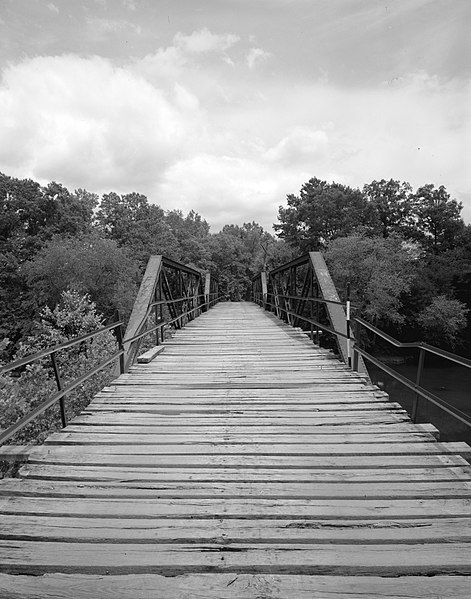
English: Looking west on the Mountain Fork Bridge, which carries County Road 38 over Mountain Fork Creek near Mena in Saline County, Arkansas, United States. Built in 1926, this Pratt pony truss bridge is listed on the National Register of Historic Places. |
||||
| Датум | |||||
| Извор | Library of Congress, Prints and Photograph Division HAER: ARK,57-CAPI.V,1-3 | ||||
| Аутор | Jeff Holder | ||||
| Дозвола (Поновно коришћење ове датотеке) |
|

|
This image is available from the United States Library of Congress's Prints and Photographs division
under the digital ID hhh.ar0092. This tag does not indicate the copyright status of the attached work. A normal copyright tag is still required. See Commons:Licensing.
|
Историја датотеке
Кликните на датум/време да бисте видели тадашњу верзију датотеке.
| Датум/време | Минијатура | Димензије | Корисник | Коментар | |
|---|---|---|---|---|---|
| тренутна | 04:03, 13. децембар 2009. | | 3.691 × 4.693 (1,61 MB) | Nyttend | {{Location|34|31|41|N|94|24|0|W}} {{Information |Description={{en|Looking west on the {{w|Mountain Fork Bridge}}, which carries County Road 38 over Mountain Fork Creek near {{w|Mena, Arkansas|Mena}} in {{w|Saline County, Arkansas|Saline County}}, {{w|Arka |
Употреба датотеке
Следећа страница користи ову датотеку:
Глобална употреба датотеке
Други викији који користе ову датотеку:
- Употреба на ar.wikipedia.org
- Употреба на ceb.wikipedia.org
- Употреба на ce.wikipedia.org
- Употреба на cy.wikipedia.org
- Употреба на en.wikipedia.org
- Употреба на es.wikipedia.org
- Употреба на fr.wikipedia.org
- Употреба на ga.wikipedia.org
- Употреба на hu.wikipedia.org
- Употреба на hy.wikipedia.org
- Употреба на ki.wikipedia.org
- Употреба на no.wikipedia.org
- Употреба на pl.wikipedia.org
- Употреба на ru.wikipedia.org
- Употреба на tt.wikipedia.org
- Употреба на ur.wikipedia.org
- Употреба на www.wikidata.org
- Употреба на zh-min-nan.wikipedia.org