Датотека:Tectonics Sumatra quake.gif

Величина овог приказа: 463 × 599 пиксела. 2 друге резолуције: 185 × 240 пиксела | 612 × 792 пиксела.
Оригинална датотека (612 × 792 пиксела, величина датотеке: 63 kB, MIME тип: image/gif, 0,2 с)
| Ово је датотека са Викимедијине оставе. Информације са њене странице са описом приказане су испод. Викимедијина остава је складиште слободно лиценциралних мултимедијалних датотека. И Ви можете да помогнете. |
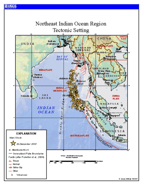
Source
https://earthquake.usgs.gov/eqinthenews/2004/usslav/ Tectonic setting of Sumatra earthquake - updated map (first maps posted by USGS was showing unrealistic plate boundaries)
This image is in the public domain in the United States because it only contains materials that originally came from the United States Geological Survey, an agency of the United States Department of the Interior. For more information, see the official USGS copyright policy.
|
Историја датотеке
Кликните на датум/време да бисте видели тадашњу верзију датотеке.
| Датум/време | Минијатура | Димензије | Корисник | Коментар | |
|---|---|---|---|---|---|
| тренутна | 14:24, 24. јануар 2006. | | 612 × 792 (63 kB) | RobinL~commonswiki | ==Source== http://earthquake.usgs.gov/eqinthenews/2004/usslav/ Tectonic setting of Sumatra earthquake - updated map (first maps posted by USGS was showing unrealistic plate boundaries) {{PD-USGov-USGS}} |
Употреба датотеке
Следећа страница користи ову датотеку:
Глобална употреба датотеке
Други викији који користе ову датотеку:
- Употреба на ar.wikipedia.org
- Употреба на ca.wikipedia.org
- Употреба на el.wikipedia.org
- Употреба на en.wikipedia.org
- Употреба на es.wikipedia.org
- Употреба на fa.wikipedia.org
- Употреба на fr.wikipedia.org
- Употреба на hi.wikipedia.org
- Употреба на id.wikipedia.org
- Употреба на ja.wikipedia.org
- Употреба на ko.wikipedia.org
- Употреба на my.wikipedia.org
- Употреба на pt.wikipedia.org
- Употреба на ru.wikipedia.org
- Употреба на sl.wikipedia.org
- Употреба на th.wikipedia.org
- Употреба на tr.wikipedia.org
- Употреба на uk.wikipedia.org
- Употреба на zh.wikipedia.org