Датотека:USACE Englebright Dam and Lake.jpg

Величина овог приказа: 800 × 526 пиксела. 4 друге резолуције: 320 × 211 пиксела | 640 × 421 пиксела | 1.024 × 674 пиксела | 1.500 × 987 пиксела.
Оригинална датотека (1.500 × 987 пиксела, величина датотеке: 638 kB, MIME тип: image/jpeg)
| Ово је датотека са Викимедијине оставе. Информације са њене странице са описом приказане су испод. Викимедијина остава је складиште слободно лиценциралних мултимедијалних датотека. И Ви можете да помогнете. |
| Опис |
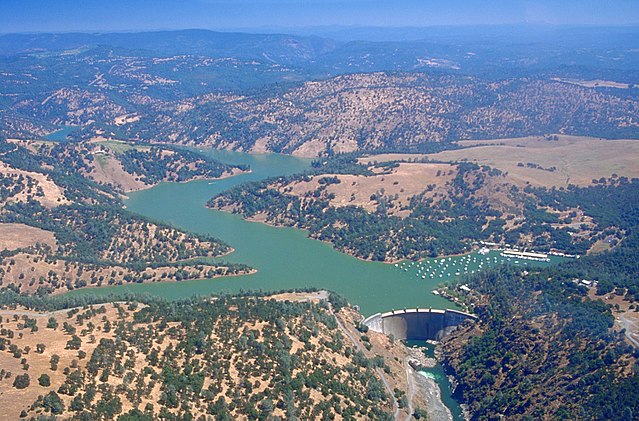
English: Englebright Dam and Lake on the Yuba River in the state of California, USA. The dam is located approximately 20 miles (32 km) east-northeast of Yuba City, California. The river and dam span the border between Yuba County and Nevada Counties. The dam was constructed in 1941 by the U.S. Army Corps of Engineers for flood control on the Yuba River.
Coordinates: 39°14′23.81″N 121°16′10.02″W / 39.2399472°N 121.26945°W |
|||
| Локација | Yuba and Nevada Counties, California, USA | |||
| Датум | not specified or unknown | |||
| Извор |
U.S. Army Corps of Engineers Digital Visual Library Image page Image description page Digital Visual Library home page |
|||
| Аутор | Michael Nevins, U.S. Army Corps of Engineers | |||
| Дозвола (Поновно коришћење ове датотеке) |
|
Историја датотеке
Кликните на датум/време да бисте видели тадашњу верзију датотеке.
| Датум/време | Минијатура | Димензије | Корисник | Коментар | |
|---|---|---|---|---|---|
| тренутна | 17:27, 5. мај 2007. | | 1.500 × 987 (638 kB) | DanMS | {{Information | Description = {{en|Englebright Dam and Lake on the Yuba River in the state of California, USA. The dam is located approximately 20 miles (32 km) east-northeast of Yuba City, California. The river and dam span the border between Yuba Cou |
Употреба датотеке
Следећа страница користи ову датотеку:
Глобална употреба датотеке
Други викији који користе ову датотеку:
- Употреба на ar.wikipedia.org
- Употреба на az.wikipedia.org
- Употреба на ceb.wikipedia.org
- Употреба на ce.wikipedia.org
- Употреба на cs.wikipedia.org
- Употреба на cy.wikipedia.org
- Употреба на en.wikipedia.org
- Употреба на en.wikivoyage.org
- Употреба на eo.wikipedia.org
- Употреба на es.wikipedia.org
- Употреба на ga.wikipedia.org
- Употреба на hu.wikipedia.org
- Употреба на hy.wikipedia.org
- Употреба на no.wikipedia.org
- Употреба на pl.wikipedia.org
- Употреба на pt.wikipedia.org
- Употреба на ru.wikipedia.org
- Употреба на tr.wikipedia.org
- Употреба на tt.wikipedia.org
- Употреба на www.wikidata.org