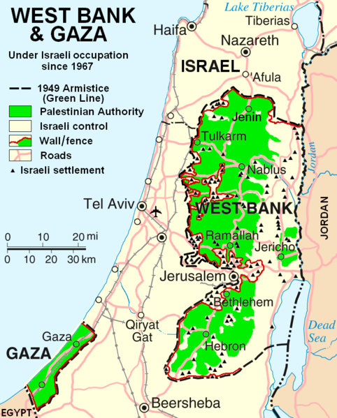
Датотека:West Bank & Gaza Map 2007 (Settlements).png

Величина овог приказа: 482 × 599 пиксела. 3 друге резолуције: 193 × 240 пиксела | 386 × 480 пиксела | 780 × 970 пиксела.
Оригинална датотека (780 × 970 пиксела, величина датотеке: 86 kB, MIME тип: image/png)
Историја датотеке
Кликните на датум/време да бисте видели тадашњу верзију датотеке.
| Датум/време | Минијатура | Димензије | Корисник | Коментар | |
|---|---|---|---|---|---|
| тренутна | 00:55, 30. октобар 2013. |  | 780 × 970 (86 kB) | Scott | Correct capitalization in legend. |
| 00:54, 30. октобар 2013. |  | 780 × 970 (86 kB) | Scott | Correct capitalization in legend. | |
| 08:21, 12. јануар 2009. |  | 780 × 970 (105 kB) | HowardMorland | Replace .gif file with identical .png file <!--{{ImageUpload|basic}}--> |
Употреба датотеке
Следећа страница користи ову датотеку:
Глобална употреба датотеке
Други викији који користе ову датотеку:
- Употреба на am.wikipedia.org
- Употреба на ar.wikipedia.org
- Употреба на ast.wikipedia.org
- Употреба на azb.wikipedia.org
- Употреба на bg.wikipedia.org
- Употреба на ca.wikipedia.org
- Употреба на ckb.wikipedia.org
- Употреба на cs.wikipedia.org
- Употреба на cy.wikipedia.org
- Употреба на da.wikipedia.org
- Употреба на de.wikipedia.org
- Употреба на de.wikinews.org
- Употреба на de.wikivoyage.org
- Употреба на en.wikipedia.org
- Talk:List of ongoing armed conflicts
- User:Timeshifter/Userboxes
- User:Gimmetrow/test
- User:Gimmetrow/test2
- User:Keizers
- Talk:Jerusalem/Archive 15
- Talk:Palestinian National Authority/Archive 2
- Wikipedia:Top 25 Report/July 13 to 19, 2014
- Wikipedia:Top 25 Report/July 20 to 26, 2014
- Wikipedia:Top 25 Report/July 27 to August 2, 2014
- Talk:State of Palestine/Archive 12
- User:Timeshifter/Userboxes/Palestine: Peace Not Apartheid. By Jimmy Carter
- User:Dare2Leap/info
- User:Timeshifter/Archive 2
- Wikipedia talk:WikiProject Israel Palestine Collaboration/Archive 9
- Употреба на en.wikinews.org
- Употреба на eo.wikipedia.org
- Употреба на es.wikipedia.org
- Употреба на eu.wikipedia.org
- Употреба на fa.wikipedia.org
- Употреба на fi.wikipedia.org
- Употреба на fo.wikipedia.org
- Употреба на fr.wikipedia.org
Још глобалног коришћења ове датотеке.