Датотека:Map of the Wabanaki Confederacy Range.png
Величина овог приказа: 800 × 420 пиксела. 3 друге резолуције: 320 × 168 пиксела | 640 × 336 пиксела | 965 × 507 пиксела.
Оригинална датотека (965 × 507 пиксела, величина датотеке: 166 kB, MIME тип: image/png)
| Ово је датотека са Викимедијине оставе. Информације са њене странице са описом приказане су испод. Викимедијина остава је складиште слободно лиценциралних мултимедијалних датотека. И Ви можете да помогнете. |
Опис
| Опис |
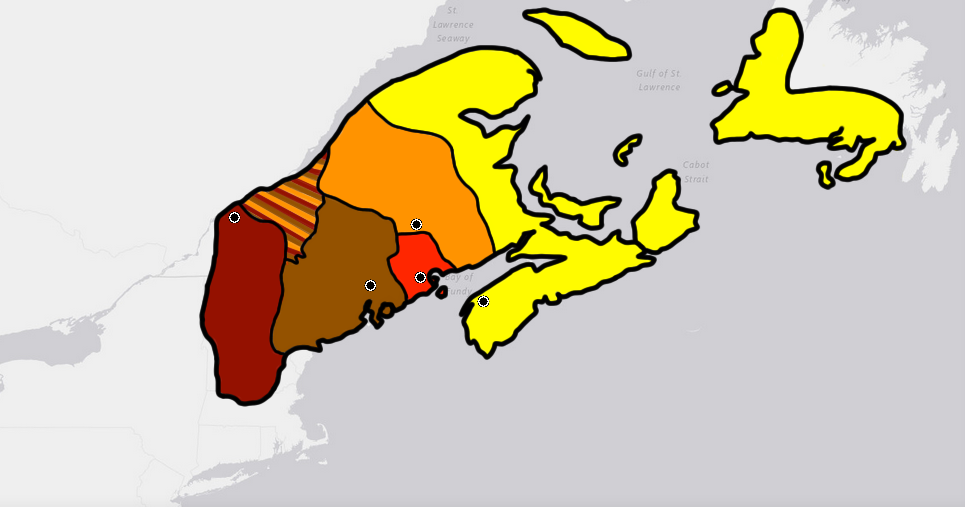
English: This is the max range of the Wabanaki Confederacy based off of cultural boundaries of the five tribal populations that made it up at around its formation in the early 1,600's. Yellow is the Miꞌkmaq. Orange is the Wəlastəkwewiyik (Maliseet), Red is the Passamaquoddy, Brown is the Penobscot, and Cayenne is the Western Abanaki. The large mixed area to the north was part of Wabanaki territory but is not part of the cultural boundaries of the individual 5 tribes. This may in part be due to it's recent acquisition (In relationship to the formation of Wabanaki) from Iroquois tribes that were pushed out of the area as identified by Samuel de Champlain during the establishment of Quebec City. Algonquin people would have started moving into the land around the same time the French would. |
| Датум | |
| Извор | Сопствено дело |
| Аутор | Wolastoq |
Лиценцирање
Ја, носилац ауторског права над овим делом, објављујем исто под следећом лиценцом:
| Ова датотека је доступна под лиценцом Creative Commons 1.0 Универзална – посвећивање јавном власништву. | |
| Особа која је учествовало у раду на овом документу посветила је дело јавном власништву, одричући се свих права на то дело широм света, по закону о ауторским правима и повезаним или сродним законским правима које би имао/имала, у мери дозвољеној законом. Можете да умножавате, мењате, расподељујете и прилагођавате дело, чак и у комерцијалне сврхе, без тражења дозволе.
|
Историја датотеке
Кликните на датум/време да бисте видели тадашњу верзију датотеке.
| Датум/време | Минијатура | Димензије | Корисник | Коментар | |
|---|---|---|---|---|---|
| тренутна | 02:31, 25. август 2020. | | 965 × 507 (166 kB) | Wolastoq | Newfoundland was not entirely inhabited by the Mi'kmaqs. The Beothuk shared the Island, living in the Northern and Eastern parts of the Island until their culture largely died out around the 1830s. The Mi'kmaq peoples would to this day survive as part of the Qalipu Mi'kmaq First Nation and Miawpukek Mi'kmaq First Nation on the Island. |
| 01:53, 25. август 2020. |  | 965 × 507 (162 kB) | Wolastoq | Includes the islands of Anticosti and Newfoundland, among others. Mi'kmaq populations on both would maintain mostly indirect involvement in Wabanaki through the other Mi'kmaq people in Wabanaki. Newfoundland for instance would have been involved in political gatherings with the Wabanaki up until the 1830s. | |
| 09:59, 12. август 2020. |  | 965 × 507 (159 kB) | Wolastoq | Dr. Harald E. L. Prins's write up shows the capital of the Wabanaki would move around to the large villages of the five tribes. As there was no single leader of Wabanaki, the council would rotate hosting the capital around for assemblies. Historically, meetings were held in Wabanaki head villages such as the (Yellow) Mi'kmaq village of Eelsetkook, the (Orange) Maliseet village of Meductic, the (Red) Passamaquoddy village at Sipayik, the (Brown) the Penobscot village Panawamskek, and the (Cay... | |
| 05:50, 12. август 2020. |  | 752 × 507 (135 kB) | Wolastoq | Uploaded own work with UploadWizard |
Употреба датотеке
4 следеће странице користе ову датотеку:
Глобална употреба датотеке
Други викији који користе ову датотеку:
- Употреба на en.wikipedia.org