Датотека:1864 Johnson's Map of India (Hindostan or British India) - Geographicus - India-j-64.jpg

Originalna datoteka (2.500 × 1.990 piksela, veličina datoteke: 1,63 MB, MIME tip: image/jpeg)
| Ovo je datoteka sa Vikimedijine ostave. Informacije sa njene stranice sa opisom prikazane su ispod. Vikimedijina ostava je skladište slobodno licenciralnih multimedijalnih datoteka. I Vi možete da pomognete. |
_-_Geographicus_-_India-j-64.jpg)
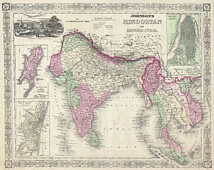
| Alvin Jewett Johnson: Johnson’s Hindostan or British India.
( |
|||||||||||||||||||||||
|---|---|---|---|---|---|---|---|---|---|---|---|---|---|---|---|---|---|---|---|---|---|---|---|
| Umetnik |
|
||||||||||||||||||||||
| Naslov |
Johnson’s Hindostan or British India. |
||||||||||||||||||||||
| Opis |
English: A very nice example of A. J. Johnson’s 1864 map of India and Southeast Asia. Covers from the Indus River eastward to include all of India, Burma, Siam (Thailand), Laos, Cambodia, Malaysia (Malacca) and Vietnam (Tonquin and Chochin). Also includes parts of Pakistan, Nepal, China, Bhutan, Sumatra and Ceylon (Sri Lanka). Offers color coding according to country and region as well as notations regarding roadways, cities, towns, and river systems. Three inset maps focus on the Island of Bombay (Mumbai), Madras, and Calcutta. An view of the Government House and Treasury in Calcutta adorns the upper left corner. Features the fretwork style border common to Johnson’s atlas work from 1864 to 1869. Published by A. J. Johnson and Ward as plate number 95 in the 1864 edition of Johnson’s New Illustrated Family Atlas. This is the last edition of the Johnson Atlas to bear the Johnson and Ward imprint, subsequent editions were attributed to Johnson exclusively. |
||||||||||||||||||||||
| Datum | 1864 (undated) | ||||||||||||||||||||||
| Dimenzije | visina: 13 in (33 cm); širina: 17 in (43,1 cm) | ||||||||||||||||||||||
| Popisni broj |
Geographicus link: India-j-64 |
||||||||||||||||||||||
| Izvor/fotograf |
Johnson, A. J., Johnson's New Illustrated Family Atlas of The World with Physical Geography, and with Descriptions Geographical, Statistical, and Historic including The Latest Federal Census, A Geographical Index, and a Chronological History of the Civil War in America, 1864.
|
||||||||||||||||||||||
| Dozvola (Ponovno korišćenje ove datoteke) |
|
||||||||||||||||||||||
Istorija datoteke
Kliknite na datum/vreme da biste videli tadašnju verziju datoteke.
| Datum/vreme | Minijatura | Dimenzije | Korisnik | Komentar | |
|---|---|---|---|---|---|
| trenutna | 11:44, 16. mart 2011. | | 2.500 × 1.990 (1,63 MB) | BotMultichill | {{subst:User:Multichill/Geographicus |link=http://www.geographicus.com/P/AntiqueMap/India-j-64 |product_name=1864 Johnson's Map of India (Hindostan or British India) |map_title=Johnson’s Hindostan or British India. |description=A very nice example of A. |
Upotreba datoteke
Sledeća stranica koristi ovu datoteku:
Globalna upotreba datoteke
Drugi vikiji koji koriste ovu datoteku:
- Upotreba na ar.wikipedia.org
- Upotreba na azb.wikipedia.org
- Upotreba na en.wikipedia.org
- Upotreba na fa.wikipedia.org
- Upotreba na incubator.wikimedia.org
- Upotreba na it.wikipedia.org
- Upotreba na ml.wikipedia.org
- Upotreba na nl.wikipedia.org
- Upotreba na ps.wikipedia.org
- Upotreba na ru.wiktionary.org
- Upotreba na sd.wikipedia.org
- Upotreba na simple.wikipedia.org
- Upotreba na skr.wikipedia.org
- Upotreba na ta.wikipedia.org
- Upotreba na th.wikipedia.org
- Upotreba na ur.wikipedia.org
- Upotreba na zh.wikipedia.org
_-_Geographicus_-_India-j-64.jpg)