Датотека:Adygea districts.png

Veličina ovog prikaza: 785 × 600 piksela. 3 druge rezolucije: 314 × 240 piksela | 628 × 480 piksela | 1.013 × 774 piksela.
Originalna datoteka (1.013 × 774 piksela, veličina datoteke: 56 kB, MIME tip: image/png)
| Ovo je datoteka sa Vikimedijine ostave. Informacije sa njene stranice sa opisom prikazane su ispod. Vikimedijina ostava je skladište slobodno licenciralnih multimedijalnih datoteka. I Vi možete da pomognete. |
Opis izmene
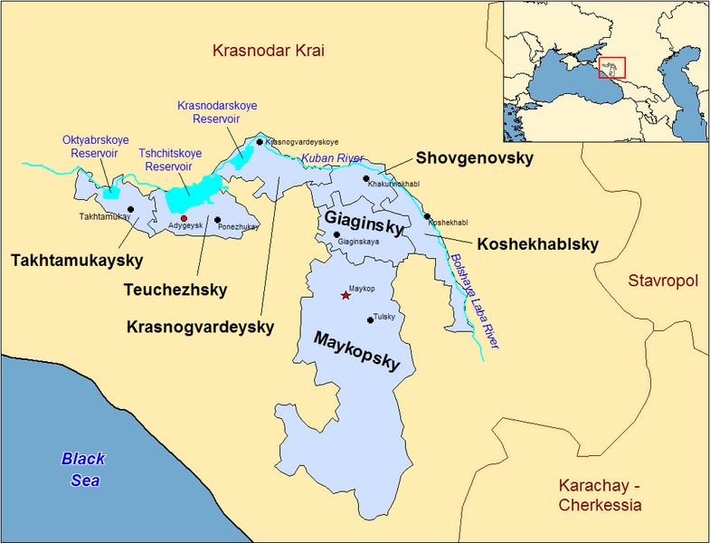
| Opis | Map of the districts of the Adygea republic of Russia. Created by Rarelibra 13:10, 30 March 2007 (UTC) for public domain use, using MapInfo Professional v8.5 and various mapping resources. |
| Datum | 30. mart 2007. (првобитни датум слања) |
| Izvor | No machine-readable source provided. Own work assumed (based on copyright claims). |
| Autor | No machine-readable author provided. Rarelibra assumed (based on copyright claims). |
Previous summary and history (en.wikipedia)
Map of the districts of the Republic of Adygea (federal subject of Russia). Created by Rarelibra 20:52, 20 December 2006 (UTC) for public domain use, using MapInfo Professional v8.5 and various mapping resources. Special thanks to w:User:Ezhiki for both his patience and input to help complete this map for his wiki project.
- 16:06, April 3, 2007 . . Rarelibra (Talk | contribs | block) . . 1056×816 (58,397 bytes) (Updated version)
- 17:35, March 27, 2007 . . Rarelibra (Talk | contribs | block) . . 823×752 (50,852 bytes) (Updated map)
- 22:34, December 20, 2006 . . Rarelibra (Talk | contribs | block) . . 1281×878 (48,913 bytes) (Map of the districts of the Republic of Adygea (a federal subject of Russia). Created by ~~~~ for public domain use with attribution under GNU. Created using MapInfo Professional v8.5 and various mapping resources. Special thanks to User:Ezhiki for hi)
- 20:52, December 20, 2006 . . Rarelibra (Talk | contribs | block) . . 1281×878 (43,557 bytes) (Map of the districts of the Republic of Adygea (federal subject of Russia). Created by ~~~~ for public domain use, using MapInfo Professional v8.5 and various mapping resources. Special thanks to User:Ezhiki for both his patience and input to help com)
Licenciranje
| Ja, tvorac ovog dela, predajem ga u javno vlasništvo. Ovo se odnosi na ceo svet. U nekim zemljama, ovo nije zakonski moguće; u tom slučaju: Ja, tvorac ovog dela dozvoljavam svakome da koristi ovo delo za bilo koju namenu, bez bilo kakvih uslova, osim uslova koje nameće zakon. |
Istorija datoteke
Kliknite na datum/vreme da biste videli tadašnju verziju datoteke.
| Datum/vreme | Minijatura | Dimenzije | Korisnik | Komentar | |
|---|---|---|---|---|---|
| trenutna | 00:53, 1. januar 2024. | | 1.013 × 774 (56 kB) | User-duck | Cropped border using CropTool with lossless mode. |
| 15:18, 23. april 2007. |  | 1.056 × 816 (57 kB) | Rarelibra | Reverted to earlier revision | |
| 17:54, 21. april 2007. |  | 1.056 × 816 (46 kB) | David Kernow~commonswiki | ||
| 18:04, 3. april 2007. |  | 1.056 × 816 (57 kB) | Rarelibra | Updated version | |
| 15:10, 30. mart 2007. |  | 823 × 752 (50 kB) | Rarelibra | Map of the districts of the Adygea republic of Russia. Created by ~~~~ for public domain use, using MapInfo Professional v8.5 and various mapping resources. |
Upotreba datoteke
Nema stranica koje koriste ovu datoteku.
Globalna upotreba datoteke
Drugi vikiji koji koriste ovu datoteku:
- Upotreba na af.wikipedia.org
- Upotreba na azb.wikipedia.org
- Upotreba na ca.wikipedia.org
- Upotreba na cy.wikipedia.org
- Upotreba na de.wikipedia.org
- Upotreba na el.wikipedia.org
- Upotreba na en.wikipedia.org
- Upotreba na fa.wikipedia.org
- Upotreba na fi.wikipedia.org
- Upotreba na frr.wikipedia.org
- Upotreba na fr.wikipedia.org
- Upotreba na incubator.wikimedia.org
- Upotreba na io.wikipedia.org
- Upotreba na it.wikipedia.org
- Upotreba na krc.wikipedia.org
- Upotreba na lv.wikipedia.org
- Upotreba na mn.wikipedia.org
- Upotreba na nl.wikipedia.org
- Upotreba na pl.wikipedia.org
- Upotreba na pl.wiktionary.org
- Upotreba na pt.wikipedia.org
- Upotreba na ru.wikivoyage.org