Датотека:Australia first map.jpg

Originalna datoteka (3.604 × 2.696 piksela, veličina datoteke: 3,81 MB, MIME tip: image/jpeg)
| Ovo je datoteka sa Vikimedijine ostave. Informacije sa njene stranice sa opisom prikazane su ispod. Vikimedijina ostava je skladište slobodno licenciralnih multimedijalnih datoteka. I Vi možete da pomognete. |
Opis izmene
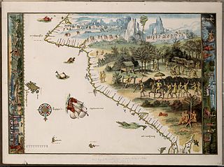
Facsimile of chart from Nicholas Vallard's manuscript sea atlas (1547), showing Jave La Grande's west coast. The facsimile was given the title "The first Map of Australia from Nicholas Vallard's Atlas, 1547" by the English publisher in 1856. The original Vallard chart was produced in Dieppe, France in the 16th century. It is thought by several writers to represent Portuguese charting of the western coast of Australia, however the geographical features (i.e. 'cap' cape, 'Illa' Island, 'illet' islet, 'port' harbour) are actually written in Catalan. This copy is held by the National Library of Australia. [cartographic material] : from the Library of Sir Thomas Phillipps, Bart. at Middle Hill, 1856. Image from the National Library of Australia: http://nla.gov.au/nla.map-rm2393 The original Vallard map is held by the Huntington Library, San Marino, California and can be viewed at http://sunsite3.berkeley.edu/hehweb/HM29.html archive copy at the Wayback Machine
From NLA catalogure information: Scale: Scale indeterminable. Publisher: [Worcestershire : Middle Hill Press, 1856] (Chester : McGahey chromo. lith.) Date: 1856 Material Type: Map Physical Description: 1 map : col. ; 37.6 x 55.4 cm. Notes: Facsimile of chart from Nicholas Vallard's manuscript sea atlas (1547), now held in the Huntington Library, San Marino, California.
Map is in folder with title: Vallard's map of the coast of Greater Java.
Licenciranje
|
Овај рад је такође у јавном власништву у државама са роком ауторства за живота аутора плус 70 година или мање.
| |
| Utvrđeno je da ova datoteka nije ograničena u pogledu autorskih prava, uključujući i sva srodna i susedna prava. | |
Istorija datoteke
Kliknite na datum/vreme da biste videli tadašnju verziju datoteke.
| Datum/vreme | Minijatura | Dimenzije | Korisnik | Komentar | |
|---|---|---|---|---|---|
| trenutna | 02:58, 17. oktobar 2006. | | 3.604 × 2.696 (3,81 MB) | Gobeirne | |
| 00:55, 1. decembar 2005. |  | 760 × 580 (110 kB) | Matilda | First map of Australia [cartographic material] : from Nicholas Vallard's atlas, 1547, in the Library of Sir Thomas Phillipps, Bart. at Middle Hill, 1856. Image from the National Library of Australia: http://nla.gov.au/nla.map-rm2393 From NLA catalogure i |
Upotreba datoteke
2 sledeće stranice koriste ovu datoteku:
Globalna upotreba datoteke
Drugi vikiji koji koriste ovu datoteku:
- Upotreba na af.wikipedia.org
- Upotreba na en.wikipedia.org
- Upotreba na es.wikipedia.org
- Upotreba na fr.wikipedia.org
- Upotreba na he.wikipedia.org
- Upotreba na id.wikipedia.org
- Upotreba na it.wikipedia.org
- Upotreba na ja.wikipedia.org
- Upotreba na jv.wikipedia.org
- Upotreba na ka.wikipedia.org
- Upotreba na mk.wikipedia.org
- Upotreba na nl.wikipedia.org
- Upotreba na pt.wikipedia.org
- Descoberta da Austrália
- Predefinição:Esboço-históriaau
- Mapas de Dieppe
- Colônia de Nova Gales do Sul
- Ordem da Austrália
- Teoria da descoberta da Austrália pelos portugueses
- Eureka Stockade
- Federação da Austrália
- Austrália Branca
- Colônia da Tasmânia
- Colônia de Queensland
- Federalismo na Austrália
- João Alfonso
- Upotreba na ru.wikipedia.org
- Upotreba na ru.wikiversity.org
- Upotreba na tr.wikipedia.org
- Upotreba na uk.wikipedia.org
Još globalnog korišćenja ove datoteke.