Датотека:Bolohoveni land from A.V. Boldur description.PNG
Veća rezolucija nije dostupna.
Bolohoveni_land_from_A.V._Boldur_description.PNG (278 × 267 piksela, veličina datoteke: 115 kB, MIME tip: image/png)
| Ovo je datoteka sa Vikimedijine ostave. Informacije sa njene stranice sa opisom prikazane su ispod. Vikimedijina ostava je skladište slobodno licenciralnih multimedijalnih datoteka. I Vi možete da pomognete. |
Opis izmene
| Opis |
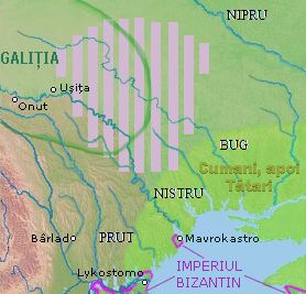
English: a map of a historical region, between Nistru and Nipru rivers, Northern Black Sea. |
| Datum | |
| Izvor |
in May 7, 2013, only for Wiki pages |
| Autor | Eurocentral, background from NASA - drawing generated since data from NASA Johnson Space Center - Earth Sciences and Image Analysis (NASA-JSC-ES&IA) ([1] Mission-Roll-Frame ISS001-E-5577, NASA Shuttle Radar Topography Mission (SRTM30) and/or Natural Earth, PD) |
| Ova datoteka je dostupna pod licencom Creative Commons 1.0 Univerzalna – posvećivanje javnom vlasništvu. | |
| Osoba koja je učestvovalo u radu na ovom dokumentu posvetila je delo javnom vlasništvu, odričući se svih prava na to delo širom sveta, po zakonu o autorskim pravima i povezanim ili srodnim zakonskim pravima koje bi imao/imala, u meri dozvoljenoj zakonom. Možete da umnožavate, menjate, raspodeljujete i prilagođavate delo, čak i u komercijalne svrhe, bez traženja dozvole.
|
Istorija datoteke
Kliknite na datum/vreme da biste videli tadašnju verziju datoteke.
| Datum/vreme | Minijatura | Dimenzije | Korisnik | Komentar | |
|---|---|---|---|---|---|
| trenutna | 05:00, 17. septembar 2021. | | 278 × 267 (115 kB) | Trecătorul răcit | Left the cities, remove their hypothetic borders |
| 20:25, 13. jul 2016. |  | 278 × 267 (115 kB) | Julieta39 | More colours, Cumans & later Tatars | |
| 22:42, 30. mart 2014. |  | 278 × 267 (112 kB) | Spiridon Ion Cepleanu | More details according with Nicolae Iorga & Alexandru Boldur | |
| 08:30, 8. maj 2013. |  | 278 × 320 (116 kB) | Eurocentral | {{subst:Upload marker added by en.wp UW}} {{Information |Description = {{en|a map of a historical region, between Nistru and Nipru rivers, Northern Black Sea.}} |Source = in May 7, 2013, only for Wiki pages<br/> '''Previously published:''' only for Wik... |
Upotreba datoteke
Sledeća stranica koristi ovu datoteku:
Globalna upotreba datoteke
Drugi vikiji koji koriste ovu datoteku:
- Upotreba na en.wikipedia.org
- Upotreba na ro.wikipedia.org
- Upotreba na ru.wikipedia.org
- Upotreba na sl.wikipedia.org
- Upotreba na uk.wikipedia.org
- Upotreba na www.wikidata.org