Датотека:Great-neck-ny-map.gif
Veća rezolucija nije dostupna.
Great-neck-ny-map.gif (575 × 425 piksela, veličina datoteke: 57 kB, MIME tip: image/gif)
| Ovo je datoteka sa Vikimedijine ostave. Informacije sa njene stranice sa opisom prikazane su ispod. Vikimedijina ostava je skladište slobodno licenciralnih multimedijalnih datoteka. I Vi možete da pomognete. |
Opis izmene
| Opis |
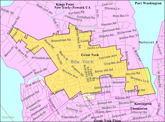
English: U.S. Census 2000 reference map for Great Neck, New York. The amber and light cross-hatched areas bordered in magenta indicate the census tracts included in the census-designated place. The amber-colored areas bordered in black indicate the extent of the incorporated Village of Great Neck. The extent of "Great Neck, New York" as the term is used by the United States Postal Service, local government and local residents includes all the incorporated and unincorporated areas of the entire Great Neck peninsula, as well as an area south of the peninsula extending to the border with Queens (New York City). |
| Datum | |
| Izvor |
|
| Autor | United States Census Bureau |
Licenciranje
This image or file is a work of a United States Census Bureau employee, taken or made as part of that person's official duties. As a work of the U.S. federal government, the image is in the public domain.
|
 |
Prvobitan dnevnik otpremanja
The original description page was here. All following user names refer to en.wikipedia.
Upload date | User | Bytes | Dimensions | Comment
- 2007-11-28 00:59 (UTC) | Americasroof | 58710 (bytes) | 575×425 | [[Great Neck, New York]] map from U.S. Census
Istorija datoteke
Kliknite na datum/vreme da biste videli tadašnju verziju datoteke.
| Datum/vreme | Minijatura | Dimenzije | Korisnik | Komentar | |
|---|---|---|---|---|---|
| trenutna | 15:33, 10. januar 2012. | | 575 × 425 (57 kB) | SreeBot | (Original text) : Great Neck, New York map from U.S. Census |
Upotreba datoteke
Sledeća stranica koristi ovu datoteku:
Globalna upotreba datoteke
Drugi vikiji koji koriste ovu datoteku:
- Upotreba na ca.wikipedia.org
- Upotreba na cy.wikipedia.org
- Upotreba na en.wikipedia.org
- Upotreba na eu.wikipedia.org
- Upotreba na fa.wikipedia.org
- Upotreba na fr.wikipedia.org
- Upotreba na ht.wikipedia.org
- Upotreba na sh.wikipedia.org
- Upotreba na www.wikidata.org