Датотека:Harlan Kentucky Aerial view.jpg

Veličina ovog prikaza: 800 × 533 piksela. 4 druge rezolucije: 320 × 213 piksela | 640 × 427 piksela | 1.024 × 683 piksela | 1.500 × 1.000 piksela.
Originalna datoteka (1.500 × 1.000 piksela, veličina datoteke: 732 kB, MIME tip: image/jpeg)
| Ovo je datoteka sa Vikimedijine ostave. Informacije sa njene stranice sa opisom prikazane su ispod. Vikimedijina ostava je skladište slobodno licenciralnih multimedijalnih datoteka. I Vi možete da pomognete. |
| Opis |
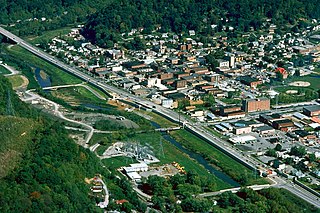
English: Aerial view of Harlan, Kentucky, USA. View is to the northeast. The main highway, U.S. Route 421, runs diagonally across the picture. The U.S. Army Corps of Engineers has constructed levees and a long floodwall along the Martins Fork River to prevent recurrence of the disastrous floods of 1977. |
|||
| Datum | ||||
| Izvor |
U.S. Army Corps of Engineers Digital Visual Library Image page Image description page Digital Visual Library home page |
|||
| Autor | U.S. Army Corps of Engineers, photographer not specified or unknown | |||
| Dozvola (Ponovno korišćenje ove datoteke) |
|
|||
| Lokacija | Harlan, Kentucky, USA |
| Положај камере | | Ова и друге слике снимљене у близини на: OpenStreetMap |
|---|
Istorija datoteke
Kliknite na datum/vreme da biste videli tadašnju verziju datoteke.
| Datum/vreme | Minijatura | Dimenzije | Korisnik | Komentar | |
|---|---|---|---|---|---|
| trenutna | 05:22, 25. mart 2007. | | 1.500 × 1.000 (732 kB) | DanMS | {{Information | Description = {{en|Aerial view of Harlan, Kentucky, USA. View is to the northeast. The main highway, U.S. Route 421, runs diagonally across the picture. The U.S. Army Corps of Engineers has constructed levees and a long floodwall along |
Upotreba datoteke
Sledeća stranica koristi ovu datoteku:
Globalna upotreba datoteke
Drugi vikiji koji koriste ovu datoteku:
- Upotreba na ar.wikipedia.org
- Upotreba na arz.wikipedia.org
- Upotreba na azb.wikipedia.org
- Upotreba na ca.wikipedia.org
- Upotreba na ceb.wikipedia.org
- Upotreba na ce.wikipedia.org
- Upotreba na en.wikipedia.org
- Upotreba na es.wikipedia.org
- Upotreba na eu.wikipedia.org
- Upotreba na fa.wikipedia.org
- Upotreba na ht.wikipedia.org
- Upotreba na hu.wikipedia.org
- Upotreba na id.wikipedia.org
- Upotreba na io.wikipedia.org
- Upotreba na it.wikipedia.org
- Upotreba na lld.wikipedia.org
- Upotreba na pl.wikipedia.org
- Upotreba na pt.wikipedia.org
- Upotreba na ru.wikipedia.org
- Upotreba na sh.wikipedia.org
- Upotreba na simple.wikipedia.org
- Upotreba na sv.wikipedia.org
- Upotreba na tl.wikipedia.org
- Upotreba na tr.wikipedia.org
- Upotreba na tt.wikipedia.org
- Upotreba na uz.wikipedia.org
- Upotreba na www.wikidata.org
- Upotreba na zh-min-nan.wikipedia.org