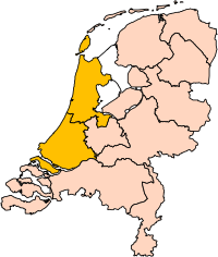
Датотека:Holland position.svg

Veličina PNG pregleda za ovu SVG datoteku je 200 × 236 piksela. 5 drugih rezolucija: 203 × 240 piksela | 407 × 480 piksela | 651 × 768 piksela | 868 × 1.024 piksela | 1.736 × 2.048 piksela.
Originalna datoteka (SVG datoteka, nominalno 200 × 236 piksela, veličina: 157 kB)
Istorija datoteke
Kliknite na datum/vreme da biste videli tadašnju verziju datoteke.
| Datum/vreme | Minijatura | Dimenzije | Korisnik | Komentar | |
|---|---|---|---|---|---|
| trenutna | 19:21, 2. mart 2019. |  | 200 × 236 (157 kB) | Thayts | update |
| 17:34, 14. januar 2007. |  | 200 × 236 (158 kB) | Roke~commonswiki | missed island | |
| 17:31, 14. januar 2007. |  | 200 × 236 (158 kB) | Roke~commonswiki | edit to User:Mtcv's Image:Noord-Holland position.svg to show North and South Holland together. {{Statistics Netherlands map municipalities}} Category:Maps of the Netherlands |
Upotreba datoteke
Sledeća stranica koristi ovu datoteku:
Globalna upotreba datoteke
Drugi vikiji koji koriste ovu datoteku:
- Upotreba na als.wikipedia.org
- Upotreba na ar.wikipedia.org
- Upotreba na arz.wikipedia.org
- Upotreba na ast.wikipedia.org
- Upotreba na ast.wiktionary.org
- Upotreba na az.wikipedia.org
- Upotreba na be-tarask.wikipedia.org
- Upotreba na be.wikipedia.org
- Upotreba na bg.wikipedia.org
- Upotreba na br.wikipedia.org
- Upotreba na ca.wikipedia.org
- Upotreba na cs.wikipedia.org
- Upotreba na cy.wikipedia.org
- Upotreba na da.wikipedia.org
- Upotreba na de.wikipedia.org
- Upotreba na de.wiktionary.org
- Upotreba na el.wikipedia.org
- Upotreba na en.wikipedia.org
- Upotreba na en.wiktionary.org
- Upotreba na eo.wikipedia.org
- Upotreba na es.wikiquote.org
- Upotreba na et.wikipedia.org
- Upotreba na eu.wikipedia.org
- Upotreba na eu.wiktionary.org
- Upotreba na fa.wikipedia.org
- Upotreba na fr.wikipedia.org
- Upotreba na fur.wikipedia.org
- Upotreba na gd.wikipedia.org
- Upotreba na gl.wikipedia.org
- Upotreba na gn.wikipedia.org
- Upotreba na gv.wikipedia.org
- Upotreba na he.wikipedia.org
- Upotreba na ia.wikipedia.org
- Upotreba na incubator.wikimedia.org
- Upotreba na io.wikipedia.org
- Upotreba na it.wikipedia.org
- Upotreba na it.wiktionary.org
- Upotreba na ja.wikipedia.org
- Upotreba na ka.wikipedia.org
- Upotreba na kn.wikipedia.org
- Upotreba na ko.wikipedia.org
- Upotreba na la.wikipedia.org
- Upotreba na lld.wikipedia.org
Još globalnog korišćenja ove datoteke.

