Датотека:Hudson Bay Route Plan of the Nelson Estuary (1927).jpg

Veličina ovog prikaza: 800 × 403 piksela. 6 drugih rezolucija: 320 × 161 piksela | 640 × 322 piksela | 1.024 × 516 piksela | 1.280 × 644 piksela | 2.560 × 1.289 piksela | 7.516 × 3.784 piksela.
Originalna datoteka (7.516 × 3.784 piksela, veličina datoteke: 10,55 MB, MIME tip: image/jpeg)
| Ovo je datoteka sa Vikimedijine ostave. Informacije sa njene stranice sa opisom prikazane su ispod. Vikimedijina ostava je skladište slobodno licenciralnih multimedijalnih datoteka. I Vi možete da pomognete. |
Opis izmene
| Opis |
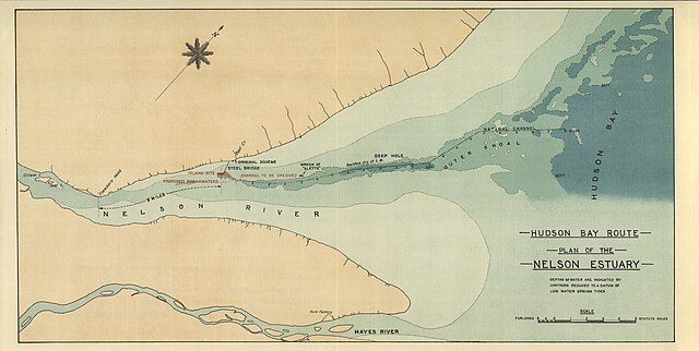
Palmer, F. Hudson Bay Route Plan of the Nelson Estuary [map]. 1:35,640. In: F. Palmer. Report on the Section of a Terminal Port for the Hudson Bay Railway. London: Harrison & Sons, Ltd., 1927. Depths of water are indicated by contours reduced to a datum of low water spring tides Report submitted to Charles A . Dunning, Minister for Railways and Canals, Government of Canada Image Courtesy of University of Manitoba : Archives & Special Collections |
| Datum | |
| Izvor | Hudson Bay Route Plan of the Nelson Estuary (1927) |
| Autor | Creator:F. Palmer via Wyman Laliberte from Edmonton, Canada |
Licenciranje
Ova datoteka je dostupna pod licencom Creative Commons Autorstvo 2.0 Generička licenca.
- Dozvoljeno je:
- da delite – da umnožavate, raspodeljujete i prenosite delo
- da prerađujete – da preradite delo
- Pod sledećim uslovima:
- autorstvo – Morate da date odgovarajuće zasluge, obezbedite vezu ka licenci i naznačite da li su izmene napravljene. Možete to uraditi na bilo koji razuman manir, ali ne na način koji predlaže da licencator odobrava vas ili vaše korišćenje.
| This image was originally posted to Flickr by Manitoba Historical Maps at https://www.flickr.com/photos/11496488@N07/3749611013. It was reviewed on 20. april 2013. by FlickreviewR and was confirmed to be licensed under the terms of the cc-by-2.0. |
| Annotations | This image is annotated: View the annotations at Commons |
.jpg)

.jpg)
Istorija datoteke
Kliknite na datum/vreme da biste videli tadašnju verziju datoteke.
| Datum/vreme | Minijatura | Dimenzije | Korisnik | Komentar | |
|---|---|---|---|---|---|
| trenutna | 05:50, 20. april 2013. | | 7.516 × 3.784 (10,55 MB) | Geo Swan | {{Information |Description=Palmer, F. Hudson Bay Route Plan of the Nelson Estuary [map]. 1:35,640. In: F. Palmer. Report on the Section of a Terminal Port for the Hudson Bay Railway. London: Harrison & Sons, Ltd., 1927. Depths of water are indicated ... |
Upotreba datoteke
Sledeća stranica koristi ovu datoteku:
Globalna upotreba datoteke
Drugi vikiji koji koriste ovu datoteku:
- Upotreba na en.wikipedia.org
- Upotreba na fr.wikipedia.org
- Upotreba na nn.wikipedia.org
- Upotreba na no.wikipedia.org
.jpg)