Датотека:Iceland satellite.jpg
Originalna datoteka(2.600 × 2.000 piksela, veličina datoteke: 869 kB, MIME tip: image/jpeg)

Vikipedija

 Ово је изабрана слика на Википедија на турски језик (Seçkin resimler) and is considered one of the finest images.

Ако мислиш да ова датотека такође треба да буде изабрана на Викимедијиној остави предложи је.
Ако поседујете слику бољег или сличног квалитета коју сте вољни објавити под одговарајућом лиценцом, свакако је пошаљите, прописно означите и предложите je.

Opis izmene

Opis
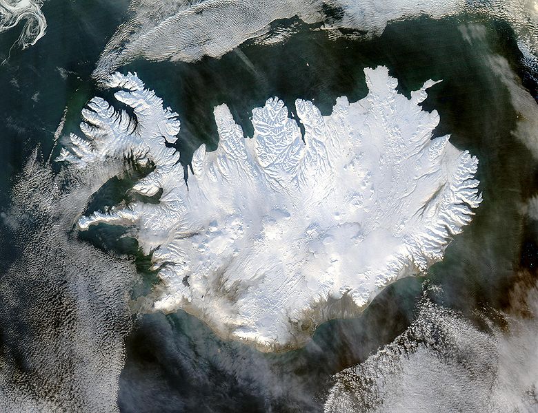
English: Iceland, from the NASA Visible Earth image gallery. More info below
Deutsch: Satellitenbild Islands aus der NASA-Fotogallerie Visible Earth. Mehr Information untenstehend auf Englisch.
Українська: Супутниковий знімок Ісландії, 29 січня 2004 року.
Datum 29. januar 2004.
Izvor http://veimages.gsfc.nasa.gov/6605/Iceland.A2004028.1355.250m.jpg
Autor Jeff Schmaltz
Dozvola
(Ponovno korišćenje ove datoteke)
Public domain Ова датотека је у јавном власништву зато што је њен аутор НАСА. НАСА-а политика ауторских права наводи „Материјали НАСА-е нису заштићени ауторским правима осим ако није другачије наведено“. (Погледајте Template:PD-USGov, NASA copyright policy page или JPL Image Use Policy.)
Упозорења:
  • Употреба НАСА-их логотипа и емблема је ограничена Америчким законом 14 CFR 1221.
  • НАСА-ин сајт хостује велики број слика Совјетске/Руске свемирске агенције и других не-Америчких свемирских агенција. Ове слике нису нужно у јавном власништву.
  • Материјали засновани на подацима Хабл телескопа су слободни само ако је њихов аутор STScI.[1] Такође погледајте {{PD-Hubble}} и {{Cc-Hubble}}.
  • Материјали са сонде SOHO су заштићени ауторским правима и потребна је дозвола за комерцијалну употребу. [2]
  • Слике са сајта APOD можда подлежу ауторским правима. [3]

Picture info

  • Description and alternative versions http://visibleearth.nasa.gov/view_rec.php?id=6605
  • Metadata: Sensor Aqua/MODIS
  • Visualization Date: 2004-01-29
  • Credit: Jeff Schmaltz, MODIS Rapid Response Team, NASA/GSFC
  • Description: Iceland lives up to its name in this image, acquired by the Moderate Resolution Imaging Spectroradiometer (MODIS) on NASA's Terra satellite on January 28, 2004. The island country is completely covered in white snow and ice, obscuring the permanent glaciers and icecaps that exist year-round. The effect of ice on this island sandwiched between the North Atlantic and the Greenland Sea, just below the Arctic Circle, is visible along its rugged northern shores. Over millennia, ice has carved out deep fjords leaving fringes of land that extend like fingers into the ocean.
  • Source: ”The purpose of NASA's Earth Observatory is to provide a freely-accessible publication on the Internet where the public can obtain new satellite imagery and scientific information about our home planet. The focus is on Earth's climate and environmental change. In particular, we hope our site is useful to public media and educators. Any and all materials published on the Earth Observatory are freely available for re-publication or re-use, except where copyright is indicated. We ask that NASA's Earth Observatory be given credit for its original materials.”

Natpisi

Dodajte objašnjenje u jednom redu o tome šta ova datoteka predstavlja

Stavke prikazane u ovoj datoteci

prikazuje

29. januar 2004

Istorija datoteke

Kliknite na datum/vreme da biste videli tadašnju verziju datoteke.

Datum/vremeMinijaturaDimenzijeKorisnikKomentar
trenutna07:49, 5. decembar 2004.Minijatura za verziju na dan 07:49, 5. decembar 2004.2.600 × 2.000 (869 kB)Ævar Arnfjörð Bjarmasonbigger version
14:06, 6. novembar 2004.Minijatura za verziju na dan 14:06, 6. novembar 2004.540 × 405 (68 kB)RanveigNASA satelite image of Iceland

Globalna upotreba datoteke

Drugi vikiji koji koriste ovu datoteku:

Još globalnog korišćenja ove datoteke.

Metapodaci