Датотека:Island of Ireland location RoI regions.svg

Veličina PNG pregleda za ovu SVG datoteku je 481 × 599 piksela. 6 drugih rezolucija: 192 × 240 piksela | 385 × 480 piksela | 616 × 768 piksela | 822 × 1.024 piksela | 1.643 × 2.048 piksela | 1.450 × 1.807 piksela.
Originalna datoteka (SVG datoteka, nominalno 1.450 × 1.807 piksela, veličina: 771 kB)
| Ovo je datoteka sa Vikimedijine ostave. Informacije sa njene stranice sa opisom prikazane su ispod. Vikimedijina ostava je skladište slobodno licenciralnih multimedijalnih datoteka. I Vi možete da pomognete. |
| Opis |
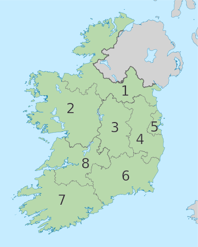
English: The island of Ireland, showing international border between Ireland and Northern Ireland, traditional provinces, traditional counties, and local authority areas in Ireland and Northern Ireland. |
| Datum | (UTC) |
| Izvor | |
| Autor |
|
| Ово је ретуширана слика, што значи да је дигитално измењена у односу на своју изворну верзију. Измене: Created regions of the Republic of Ireland. Изворна верзија се може видети овде: Island of Ireland location map.svg. Измене је направио: Mabuska.
|
Ja, nosilac autorskog prava nad ovim delom, objavljujem isto pod sledećom licencom:
Ova datoteka je dostupna pod licencom Creative Commons Autorstvo-Deliti pod istim uslovima 3.0 Unported.
- Dozvoljeno je:
- da delite – da umnožavate, raspodeljujete i prenosite delo
- da prerađujete – da preradite delo
- Pod sledećim uslovima:
- autorstvo – Morate da date odgovarajuće zasluge, obezbedite vezu ka licenci i naznačite da li su izmene napravljene. Možete to uraditi na bilo koji razuman manir, ali ne na način koji predlaže da licencator odobrava vas ili vaše korišćenje.
- deliti pod istim uslovima – Ako izmenite, preobrazite ili dogradite ovaj materijal, morate podeliti svoje doprinose pod istom ili kompatibilnom licencom kao original.
Prvobitan dnevnik otpremanja
This image is a derivative work of the following images:
- File:Island_of_Ireland_location_map.svg licensed with Cc-by-sa-3.0
- 2010-03-06T20:43:33Z Rannpháirtí anaithnid 1450x1807 (679207 Bytes) Fix incorrectly coloured isands.
- 2010-03-03T22:19:29Z Rannpháirtí anaithnid 1450x1807 (679744 Bytes) {{Information |Description={{de|Positionskarte von [[:de:Irland|Irland]]}} Quadratische Plattkarte, N-S-Streckung 170 %. Geographische Begrenzung der Karte: * N: 55.6° N * S: 51.2° N * W: 11.0° W * O: 5.0° W {{en|Location
Uploaded with derivativeFX
Istorija datoteke
Kliknite na datum/vreme da biste videli tadašnju verziju datoteke.
| Datum/vreme | Minijatura | Dimenzije | Korisnik | Komentar | |
|---|---|---|---|---|---|
| trenutna | 13:04, 14. septembar 2010. | | 1.450 × 1.807 (771 kB) | Mabuska | Fixed external entity colours to prevent distraction from subject and also realigned number 4 |
| 16:40, 29. avgust 2010. |  | 1.450 × 1.807 (758 kB) | Mabuska | {{Information |Description={{en|The island of Ireland, showing international border between Northern Ireland and Republic of Ireland, traditional provinces, traditional counties, and local authority areas in the Republic of Ireland and Northern Ireland.}} |
Upotreba datoteke
Sledeća stranica koristi ovu datoteku:
Globalna upotreba datoteke
Drugi vikiji koji koriste ovu datoteku:
- Upotreba na fr.wikipedia.org
- Upotreba na gv.wikipedia.org