Датотека:Italy 1000 AD-de.svg

Veličina PNG pregleda za ovu SVG datoteku je 419 × 600 piksela. 6 drugih rezolucija: 167 × 240 piksela | 335 × 480 piksela | 536 × 768 piksela | 715 × 1.024 piksela | 1.430 × 2.048 piksela | 572 × 819 piksela.
Originalna datoteka (SVG datoteka, nominalno 572 × 819 piksela, veličina: 334 kB)
| Ovo je datoteka sa Vikimedijine ostave. Informacije sa njene stranice sa opisom prikazane su ispod. Vikimedijina ostava je skladište slobodno licenciralnih multimedijalnih datoteka. I Vi možete da pomognete. |
Opis izmene
| Opis |
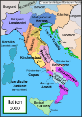
English: Political map of Italy in 1000 AD (CE). German translation of Image:Italy_1000_AD.svg which was created by MapMaster.
Part of a series of maps on the history of Italy:
|
| Datum | 20. decembar 2007. (првобитни датум слања) |
| Izvor | No machine-readable source provided. Own work assumed (based on copyright claims). |
| Autor | No machine-readable author provided. Bamse assumed (based on copyright claims). |
| Ostale verzije |
[]
SVG:
PNG:
|


|
This SVG file contains embedded text that can be translated into your language, using any capable SVG editor, text editor or the SVG Translate tool. For more information see: About translating SVG files. |
References
- Bjorklund, Oddvar; Holmboe, Haakon; Rohr, Anders (1970) Historical Atlas of the World, Barnes & Noble, NY, SBN: 389-00253-4.
- This map from Allyn & Bacon, Longman, textbook publishers.
- This map of the w:en:Holy Roman Empire
- A map from Attilios
- This map of 1050 AD Italy, from the 1923 The Historical Atlas by William R. Shepherd
- This map of 1000 AD Italy from Fordham University, adapted from Muir's Historical Atlas, (1911).
In addition, a number of other sources were consulted in an effort to determine the following matters:
- The extent of Venetian control over the cities of Dalmatia such as Zara and Spalato. Although the Venetians had been pushed off the mainland earlier, in the period around the year 1000, the Venetians made an effort to recover these cities.
- The extent of Saracen control over Corsica and Sardinia. Information is sparse. The apparent situation is that the Muslims had several bases on the coasts of these islands, but did not control the countryside (such as they did in Sicily).
- Whether or not the principalities of Capua and Benevento were separate states in the year 1000. Based on lists of their rulers (various Pandulfs and Landulfs), the answer seems to be "yes".
- Who controlled the Balkans on the southeastern border of the Kingdom of Croatia. Candidates include Bulgaria, the Byzantine Empire, Croatia, and Serbia.
As noted, there is significant disagreement among sources on these questions.
This map was commissioned by Attilios, and there is also a discussion to be found on MapMaster's English talk page.
Licenciranje
Ja, nosilac autorskog prava nad ovim delom, objavljujem isto pod sledećom licencom:

|
Data je dozvola da se kopira, distribuira i/ili menja ovaj dokument pod uslovima GNU-ove licence za slobodnu dokumentaciju, verzije 1.2 ili bilo koje novije verzije koju objavi Zadužbina za slobodni softver; bez nepromenljivih odeljaka i bez teksta na naslovnoj i zadnjoj strani. Tekst licence možete pročitati ovde. |
| Ova datoteka je dostupna pod licencom Creative Commons Autorstvo-Deliti pod istim uslovima 3.0 Unported. | ||
| ||
| Ova licenca je dodata na ovu datoteku kao deo ažuriranja GFDL licence. |
Istorija datoteke
Kliknite na datum/vreme da biste videli tadašnju verziju datoteke.
| Datum/vreme | Minijatura | Dimenzije | Korisnik | Komentar | |
|---|---|---|---|---|---|
| trenutna | 18:36, 11. april 2009. | | 572 × 819 (334 kB) | Rhegion | aggiunta Reggio |
| 10:05, 20. decembar 2007. |  | 572 × 819 (332 kB) | Bamse | == Summary == '''de:''' Political map of Italy in 1000 AD (CE). German translation of Image:Italy_1000_AD.svg which was created by MapMaster. Part of a series of maps on the history of Italy: <gallery> Image:Italy and Illyria 1084 v2.svg|1084 AD Im |
Upotreba datoteke
Nema stranica koje koriste ovu datoteku.
Globalna upotreba datoteke
Drugi vikiji koji koriste ovu datoteku:
- Upotreba na da.wikipedia.org
- Upotreba na de.wikipedia.org
- 1011
- 1016
- 1018
- 1000
- Korsika
- Mark (Territorium)
- Etrurien
- Pietro II. Orseolo
- Herzogtum Benevent
- Herzogtum Spoleto
- Pietro II. Candiano
- Markgrafschaft Verona
- Pietro Orseolo
- Fürstentum Capua
- Pietro Badoer
- Vitale Candiano
- Tribuno Memmo
- Wikipedia:Kartenwerkstatt/Archiv/2007-12
- Herzogtum Amalfi
- Normannische Eroberung Süditaliens
- Katepanat Italien
- Abu l-Qasim (Emir)
- Hassan al-Kalbi
- Ottone Orseolo
- Pietro III. Candiano
- Pietro IV. Candiano
- Civita
- Nikephoros Phokas der Ältere
- Pandulf I.
- Italien-Runensteine
- Benutzer:Methodios/Boioannes
- Giovanni Orseolo
- Emirat von Sizilien
- Markgrafschaft Tuscien
- Waldrada (ductrix)
- Cesina
- Liste der historischen Staaten in Italien
- Maria (ductrix)
- Johanna (ductrix)
- Italienische Münzgeschichte
- Upotreba na de.wikibooks.org
- Upotreba na de.wikiversity.org
- Upotreba na eo.wikipedia.org
- Upotreba na nl.wikipedia.org
- Upotreba na uk.wikipedia.org