Датотека:Kingdom of Hungary counties-2.svg

Veličina PNG pregleda za ovu SVG datoteku je 779 × 513 piksela. 5 drugih rezolucija: 320 × 211 piksela | 640 × 421 piksela | 1.024 × 674 piksela | 1.280 × 843 piksela | 2.560 × 1.686 piksela.
Originalna datoteka (SVG datoteka, nominalno 779 × 513 piksela, veličina: 265 kB)
| Ovo je datoteka sa Vikimedijine ostave. Informacije sa njene stranice sa opisom prikazane su ispod. Vikimedijina ostava je skladište slobodno licenciralnih multimedijalnih datoteka. I Vi možete da pomognete. |
| Opis |
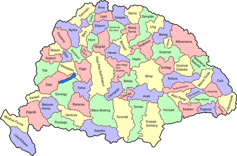
Map of counties of Kingdom of Hungary (Hungary proper and Croatia & Slavonia), 1886-1918. I have organised this into layers: Three layers of paths for the counties, for the county borders, and for external border. and one layer for the text labels. I have added basic styles and classified all elements. I have given all elements reasonable IDs the counties (the county name) and the borders (the names of the counties on each side) and the text labels (the names of the counties, with underscores indicating where they are split across labels). The counties are classed into four styles to make a four colour map, of course the colours can be changed just by changing the style (there as a fifth style for Lake Balaton, which does not show up very well on tis uploaded one). The main thing now is to fix the text styles. |
||
| Datum | (UTC) | ||
| Izvor | |||
| Autor |
|
||
| Ostale verzije |
|

| Ово је ретуширана слика, што значи да је дигитално измењена у односу на своју изворну верзију. Измене: As described - added more useful metadata and structure. Изворна верзија се може видети овде: Kingdom of Hungary counties.svg. Измене је направио: SimonTrew.
|
Ja, nosilac autorskog prava nad ovim delom, objavljujem isto pod sledećom licencom:
| Ja, tvorac ovog dela, predajem ga u javno vlasništvo. Ovo se odnosi na ceo svet. U nekim zemljama, ovo nije zakonski moguće; u tom slučaju: Ja, tvorac ovog dela dozvoljavam svakome da koristi ovo delo za bilo koju namenu, bez bilo kakvih uslova, osim uslova koje nameće zakon. |
Prvobitan dnevnik otpremanja
This image is a derivative work of the following images:
- File:Kingdom_of_Hungary_counties.svg licensed with PD-self
- 2007-08-20T20:25:30Z Xavax 779x513 (240591 Bytes) == Summary == {{Information| |Description= Map of counties of Hungary with Croatia & Slavonia, 1886-1918 |Source=own drawing |Date=April 30, 2006 |Author=[[User:IMeowbot]] |Permission= |other_versions= }} == Licensing == {{P
- 2006-04-30T22:10:47Z IMeowbot 779x513 (228524 Bytes) line weight
- 2006-04-30T21:34:49Z IMeowbot 779x513 (225942 Bytes)
- 2006-04-30T18:34:30Z IMeowbot 779x513 (199213 Bytes) {{Information| |Description= Map of late 1870s Hungary counties |Source=own drawing |Date=April 30, 2006 |Author=[[User:IMeowbot]] |Permission= |other_versions= }}
Uploaded with derivativeFX
Istorija datoteke
Kliknite na datum/vreme da biste videli tadašnju verziju datoteke.
| Datum/vreme | Minijatura | Dimenzije | Korisnik | Komentar | |
|---|---|---|---|---|---|
| trenutna | 19:57, 5. decembar 2009. | | 779 × 513 (265 kB) | SimonTrew | I missed some fixes of Veszprém |
| 19:55, 5. decembar 2009. |  | 779 × 513 (265 kB) | SimonTrew | Fix spelling of Vesprém, as I have just done on original. | |
| 16:29, 3. decembar 2009. |  | 779 × 513 (265 kB) | SimonTrew | Fix spelling of Pozsony, as I have just done on original work | |
| 15:37, 3. decembar 2009. |  | 779 × 513 (265 kB) | SimonTrew | Made four colour map. The text still only uses one style at the moment, this needs to be made to match the four styles used for the four colours for the counties, but this is easier to do once it is uploaded and I can print the png. Sorry if this is "not | |
| 13:29, 3. decembar 2009. |  | 779 × 513 (287 kB) | SimonTrew | Fixed the few errors in borders, removed unnecessary style fields from text (Inkscape adds them but they are covered by other fields), text still needs doing better | |
| 03:16, 3. decembar 2009. |  | 779 × 513 (286 kB) | SimonTrew | {{Information |Description=Map of counties of Kingdom of Hungary (Hungary proper and Croatia & Slavonia), 1886-1918. I have organised this into layers: Three layers of paths for the counties, for the county borders, and for external border. and one layer |
Upotreba datoteke
Sledeća stranica koristi ovu datoteku:
Globalna upotreba datoteke
Drugi vikiji koji koriste ovu datoteku:
- Upotreba na ar.wikipedia.org
- Upotreba na bs.wikipedia.org
- Upotreba na ceb.wikipedia.org
- Upotreba na ckb.wikipedia.org
- Upotreba na da.wikipedia.org
- Upotreba na de.wikipedia.org
- Upotreba na en.wikipedia.org
- User talk:Random user 8384993
- Wikipedia talk:WikiProject Hungary/Archive 2
- Module:Location map/data/Kingdom of Hungary/doc
- Wikipedia:Redirects for discussion/Log/2015 April 19
- User:Drkazmer/Jewish centres in the Kingdom of Hungary
- Wikipedia:Graphics Lab/Map workshop/Archive/2017/Sep 2017
- Module:Location map/data/Kingdom of Hungary
- Upotreba na fa.wikipedia.org
- Upotreba na fr.wikipedia.org
- Upotreba na hu.wikipedia.org
- Upotreba na kn.wikipedia.org
- Upotreba na pt.wikipedia.org
- Upotreba na rue.wikipedia.org
- Upotreba na si.wikipedia.org
- Upotreba na tg.wikipedia.org
- Upotreba na tr.wikipedia.org
- Upotreba na uz.wikipedia.org
- Upotreba na war.wikipedia.org