Датотека:Main land-cover trajectories from the 1960s to 2015.jpg
Veličina ovog prikaza: 800 × 437 piksela. 3 druge rezolucije: 320 × 175 piksela | 640 × 350 piksela | 1.200 × 656 piksela.
Originalna datoteka (1.200 × 656 piksela, veličina datoteke: 106 kB, MIME tip: image/jpeg)
| Ovo je datoteka sa Vikimedijine ostave. Informacije sa njene stranice sa opisom prikazane su ispod. Vikimedijina ostava je skladište slobodno licenciralnih multimedijalnih datoteka. I Vi možete da pomognete. |
Opis izmene
| Opis |
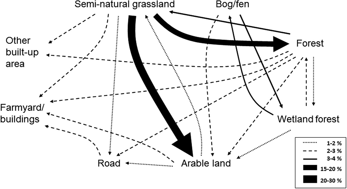
English: The line style and relative thickness of the lines indicates the percentage of total area changed. Changes less than 1% and land-cover classes with all changes less than 1% (i.e. semi-natural wetlands and water) are not included. |
| Datum | |
| Izvor | https://www.tandfonline.com/doi/full/10.1080/1747423X.2018.1539779# |
| Autor | Sigrun Aune |
Licenciranje
Ova datoteka je dostupna pod licencom Creative Commons Autorstvo-Deliti pod istim uslovima 4.0 Međunarodna.
- Dozvoljeno je:
- da delite – da umnožavate, raspodeljujete i prenosite delo
- da prerađujete – da preradite delo
- Pod sledećim uslovima:
- autorstvo – Morate da date odgovarajuće zasluge, obezbedite vezu ka licenci i naznačite da li su izmene napravljene. Možete to uraditi na bilo koji razuman manir, ali ne na način koji predlaže da licencator odobrava vas ili vaše korišćenje.
- deliti pod istim uslovima – Ako izmenite, preobrazite ili dogradite ovaj materijal, morate podeliti svoje doprinose pod istom ili kompatibilnom licencom kao original.

|
This media file is uncategorized.
Please help improve this media file by adding it to one or more categories, so it may be associated with related media files (how?), and so that it can be more easily found.
Please notify the uploader with {{subst:Please link images|File:Main land-cover trajectories from the 1960s to 2015.jpg}} ~~~~ |
Istorija datoteke
Kliknite na datum/vreme da biste videli tadašnju verziju datoteke.
| Datum/vreme | Minijatura | Dimenzije | Korisnik | Komentar | |
|---|---|---|---|---|---|
| trenutna | 13:01, 27. april 2020. | | 1.200 × 656 (106 kB) | Lachrichri | Uploaded a work by Sigrun Aune from https://www.tandfonline.com/doi/full/10.1080/1747423X.2018.1539779# with UploadWizard |
Upotreba datoteke
Sledeća stranica koristi ovu datoteku:
Globalna upotreba datoteke
Drugi vikiji koji koriste ovu datoteku:
- Upotreba na en.wikipedia.org
- Upotreba na es.wikipedia.org