Датотека:Mauritius rel90.jpg

Veličina ovog prikaza: 497 × 599 piksela. 3 druge rezolucije: 199 × 240 piksela | 398 × 480 piksela | 1.000 × 1.206 piksela.
Originalna datoteka (1.000 × 1.206 piksela, veličina datoteke: 236 kB, MIME tip: image/jpeg)
| Ovo je datoteka sa Vikimedijine ostave. Informacije sa njene stranice sa opisom prikazane su ispod. Vikimedijina ostava je skladište slobodno licenciralnih multimedijalnih datoteka. I Vi možete da pomognete. |
Opis izmene
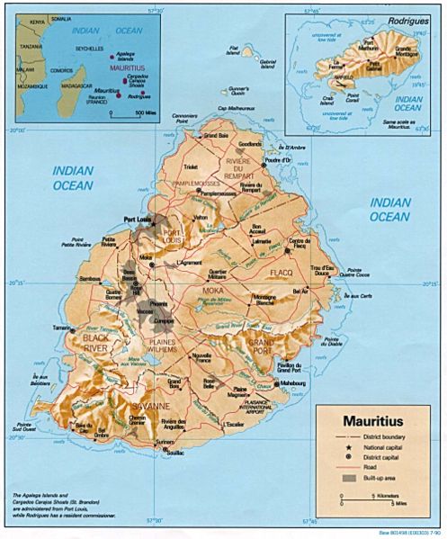
| Opis | Relief map of Mauritius, with inset of Rodrigues Island. US Central Intelligence Agency, 1990. |
| Datum | |
| Izvor | University of Texas Libraries, Perry-Castañeda Library Map Collection: Mauritius Maps |
| Autor | CIA |
Licenciranje
| This image is a work of a Central Intelligence Agency employee, taken or made as part of that person's official duties. As a Work of the United States Government, this image or media is in the public domain in the United States.
|

|
Istorija datoteke
Kliknite na datum/vreme da biste videli tadašnju verziju datoteke.
| Datum/vreme | Minijatura | Dimenzije | Korisnik | Komentar | |
|---|---|---|---|---|---|
| trenutna | 00:31, 12. decembar 2006. | | 1.000 × 1.206 (236 kB) | Electionworld | {{ew|en|Tom Radulovich}} {{PD-USGov-CIA}} Relief map of {{link|Mauritius}}, with inset of Rodrigues Island. US Central Intelligence Agency, 1990. |
Upotreba datoteke
Sledeća stranica koristi ovu datoteku:
Globalna upotreba datoteke
Drugi vikiji koji koriste ovu datoteku:
- Upotreba na fr.wikipedia.org
- Upotreba na gd.wikipedia.org
- Upotreba na hr.wiktionary.org
- Upotreba na ht.wikipedia.org
- Upotreba na ru.wikipedia.org
- Upotreba na uk.wikipedia.org
- Upotreba na vec.wikipedia.org
- Upotreba na vep.wikipedia.org
- Upotreba na www.wikidata.org
- Upotreba na yo.wikipedia.org
- Upotreba na zh.wikipedia.org