Датотека:Sea of Okhotsk Season Winter Summer 2008.jpg

Originalna datoteka(6.256 × 6.126 piksela, veličina datoteke: 8,89 MB, MIME tip: image/jpeg)

Opis izmene

Opis
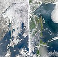
English: The Sea of Okhotsk in winter and summer 2008. The Sea of Okhotsk owes its seasonal swings to its geography. The Russian-administered Kurile Islands shelter the sea from the currents of the open Pacific Ocean to the east, while the islands of Japan block warm currents from the south. This limits the circulation of warm water through the sea. At the same time, the Amur River pours fresh water into the Sea of Okhotsk. The fresh water remains trapped in the top 50 meters (165 feet) of the sea by a layer of dense, cold, salty water. Winter brings frigid temperatures from Siberia, and the relatively fresh water near the sea’s surface freezes quickly.

On the other side of the pendulum is the ice-free and snow-free landscape of summer, shown in the lower image. Warm summer currents and a warm summer sun melt the ice, revealing open water and a green, forest-covered landscape. From the coast to the tree line, 90 percent of the Shiretoko Peninsula is covered with pristine vegetation ranging from a cool, broadleaf forest near the coast to an alpine coniferous forest in the mountains that run up the center of the peninsula. The bare, rocky mountain tops are above the tree line and are tan in this photo-like image.

This wilderness is an oasis for wildlife. During the winter, ice algae grow in the mineral-rich waters under the ice. As the ice melts, other forms of phytoplankton flourish. The highly productive waters sustain a diverse and thriving ecosystem. According to the United Nations, the phytoplankton and the zooplankton that eat the phytoplankton are at the base of the food chain for 28 species of marine mammals and 223 species of marine fish. Since the region depends on the annual sea ice, it is particularly prone to global warming.

The Moderate Resolution Imaging Spectroradiometer (MODIS) on NASA’s Aqua satellite captured these images on March 8, 2008, top, and June 5, 2008, bottom.
日本語: オホーツク海の季節:冬と夏(2008年)
Datum
Izvor The Earth Observatory - NASA - https://earthobservatory.nasa.gov/images/8893/shiretoko-peninsula
Autor Ocean Color Image Gallery. NASA. Accessed July 3, 2008.
Ostale verzije

Licenciranje

Public domain Ова датотека је у јавном власништву зато што је њен аутор НАСА. НАСА-а политика ауторских права наводи „Материјали НАСА-е нису заштићени ауторским правима осим ако није другачије наведено“. (Погледајте Template:PD-USGov, NASA copyright policy page или JPL Image Use Policy.)
Упозорења:
  • Употреба НАСА-их логотипа и емблема је ограничена Америчким законом 14 CFR 1221.
  • НАСА-ин сајт хостује велики број слика Совјетске/Руске свемирске агенције и других не-Америчких свемирских агенција. Ове слике нису нужно у јавном власништву.
  • Материјали засновани на подацима Хабл телескопа су слободни само ако је њихов аутор STScI.[1] Такође погледајте {{PD-Hubble}} и {{Cc-Hubble}}.
  • Материјали са сонде SOHO су заштићени ауторским правима и потребна је дозвола за комерцијалну употребу. [2]
  • Слике са сајта APOD можда подлежу ауторским правима. [3]

Natpisi

Dodajte objašnjenje u jednom redu o tome šta ova datoteka predstavlja
The Sea of Okhotsk in winter and summer, 2008.

Stavke prikazane u ovoj datoteci

prikazuje

Ohotsko more Serbian (transliteracija)

Hokaido Serbian (transliteracija)

Kurilska ostrva Serbian (transliteracija)

Shikotan English

Urup English

8. mart 2008

Istorija datoteke

Kliknite na datum/vreme da biste videli tadašnju verziju datoteke.

Datum/vremeMinijaturaDimenzijeKorisnikKomentar
trenutna07:58, 26. april 2022.Minijatura za verziju na dan 07:58, 26. april 2022.6.256 × 6.126 (8,89 MB)ArtanisenUploaded a work by Ocean Color Image Gallery. NASA. Accessed July 3, 2008. from The Earth Observatory - NASA - https://earthobservatory.nasa.gov/images/8893/shiretoko-peninsula with UploadWizard

Sledeća stranica koristi ovu datoteku:

Globalna upotreba datoteke

Drugi vikiji koji koriste ovu datoteku:

Metapodaci