Датотека:Wfm firth of forth.jpg

Veličina ovog prikaza: 800 × 593 piksela. 4 druge rezolucije: 320 × 237 piksela | 640 × 474 piksela | 1.024 × 758 piksela | 1.280 × 948 piksela.
Originalna datoteka (1.280 × 948 piksela, veličina datoteke: 289 kB, MIME tip: image/jpeg)
| Ovo je datoteka sa Vikimedijine ostave. Informacije sa njene stranice sa opisom prikazane su ispod. Vikimedijina ostava je skladište slobodno licenciralnih multimedijalnih datoteka. I Vi možete da pomognete. |
Opis izmene
| Opis |
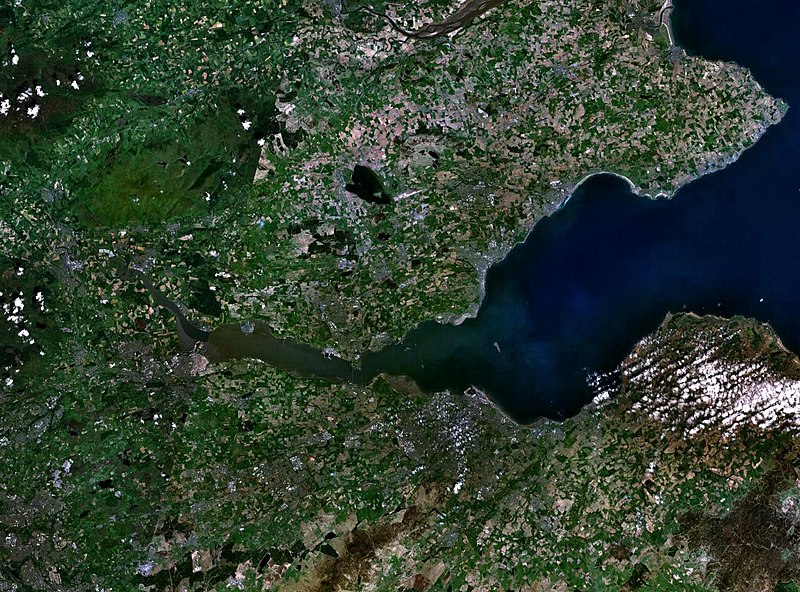
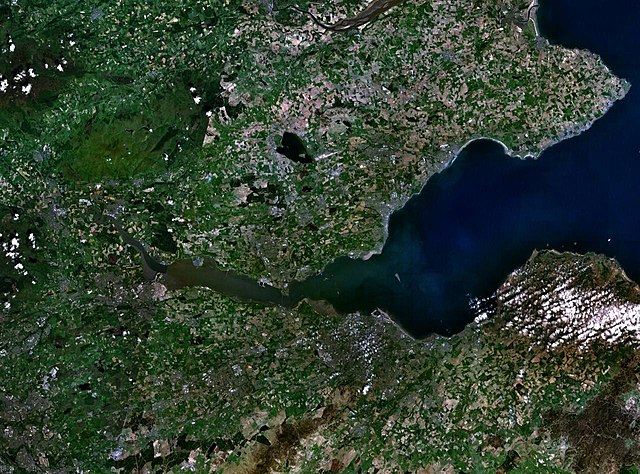
English: The Firth of the river Forth, on the east coast of Scotland. The two forth bridges are visible near the centre of the frame. Stirling is at the extreme left side. |
| Datum | 3. avgust 2005. (upload date) |
| Izvor | Satellite imagery taken by screenshot from NASA World Wind software |
| Autor | NASA |
Licenciranje
| This image is in the public domain because it is a screenshot from NASA’s globe software World Wind using a public domain layer, such as Blue Marble, MODIS, Landsat, SRTM, USGS or GLOBE.
|
 |
Istorija datoteke
Kliknite na datum/vreme da biste videli tadašnju verziju datoteke.
| Datum/vreme | Minijatura | Dimenzije | Korisnik | Komentar | |
|---|---|---|---|---|---|
| trenutna | 11:38, 3. avgust 2005. | | 1.280 × 948 (289 kB) | Finlay McWalter | The Firth of the river Forth, on the east coast of Scotland. The two forth bridges are visible near the centre of the frame. Stirling is at the extreme left side. Image made with NASA World Wind. {{PD-USGov-NASA}} category:satellite photos |
Upotreba datoteke
Sledeća stranica koristi ovu datoteku:
Globalna upotreba datoteke
Drugi vikiji koji koriste ovu datoteku:
- Upotreba na ar.wikipedia.org
- Upotreba na be.wikipedia.org
- Upotreba na bg.wikipedia.org
- Upotreba na br.wikipedia.org
- Upotreba na ca.wikipedia.org
- Upotreba na ceb.wikipedia.org
- Upotreba na cs.wikipedia.org
- Upotreba na cy.wikipedia.org
- Upotreba na de.wikipedia.org
- Upotreba na el.wikipedia.org
- Upotreba na en.wikipedia.org
- Upotreba na en.wikivoyage.org
- Upotreba na eo.wikipedia.org
- Upotreba na es.wikipedia.org
- Upotreba na et.wikipedia.org
- Upotreba na eu.wikipedia.org
- Upotreba na fa.wikipedia.org
- Upotreba na fr.wikipedia.org
- Upotreba na ga.wikipedia.org
- Upotreba na gd.wikipedia.org
- Upotreba na ha.wikipedia.org
- Upotreba na he.wikipedia.org
- Upotreba na hi.wikipedia.org
- Upotreba na ia.wikipedia.org
- Upotreba na is.wikipedia.org
- Upotreba na it.wikipedia.org
- Upotreba na it.wikivoyage.org
- Upotreba na ja.wikipedia.org
- Upotreba na kbd.wikipedia.org
- Upotreba na lt.wikipedia.org
- Upotreba na mt.wikipedia.org
- Upotreba na nl.wikipedia.org
- Upotreba na nn.wikipedia.org
- Upotreba na no.wikipedia.org
- Upotreba na pl.wikipedia.org
- Upotreba na pt.wikipedia.org
- Upotreba na ro.wikipedia.org
- Upotreba na ru.wikipedia.org
Još globalnog korišćenja ove datoteke.