Датотека:10May 16May Battle of Belgium.PNG

Величина овог приказа: 775 × 599 пиксела. 3 друге резолуције: 311 × 240 пиксела | 621 × 480 пиксела | 891 × 689 пиксела.
Оригинална датотека (891 × 689 пиксела, величина датотеке: 156 kB, MIME тип: image/png)
| Ово је датотека са Викимедијине оставе. Информације са њене странице са описом приказане су испод. Викимедијина остава је складиште слободно лиценциралних мултимедијалних датотека. И Ви можете да помогнете. |
| Опис |
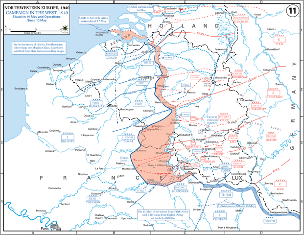
English: The German advance between 10 May and 16 May 1940. The red area denotes the territory captured by Germany during this time. The German field armies and Corps are shown in red. The red plan icon indicates the German airborne attack on the Belgian fortress of Eben-Emael. The operating area of the various Belgian, British, and French field armies and Army groups are shown in blue. The checkered white and blue area denotes the French Maginot Line. The commanders of the various units are shown under their respective formation. Solid lines represent the boundaries between each major unit. Dotted lines depict lines of advance. Key dates are shown in boxes. |
| Датум | (UTC) |
| Извор |
(Original text: http://www.dean.usma.edu/history/web03/atlases/ww2%20europe/EuropeanTheaterGIF/WWIIEurope11.gif) Archive link to original website used for the map and the archive link to the map source page. Current link to map, and link to map source page. |
| Аутор | The History Department of the United States Military Academy |
| Остале верзије | File:10May-16May1940-Fall Gelb.jpg |
Лиценцирање
Ова датотека је рад припадника Америчке војске или особе запослене у њој и начињена је за време обављања дужности те особе. Као рад америчке савезне владе, ова датотека је у јавном власништву у САД-у.
|
 |
Првобитан дневник отпремања
Пребачено са en.wikipedia на Оставу од стране Piotrus помоћу CommonsHelper.
Оригиналан опис странице је био овде. Сва наведена корисничка имена воде на en.wikipedia.
- 2009-11-08 19:43 Coldplay Expert 891×689× (159258 bytes) {{Information |Description = The German advance until noon, 16 May 1940. The map also reveals the dispositions of the Belgian Army and its allies. |Source = http://www.dean.usma.edu/history/web03/atlases/ww2%20europe/EuropeanTheaterGIF/WWIIEu
Историја датотеке
Кликните на датум/време да бисте видели тадашњу верзију датотеке.
| Датум/време | Минијатура | Димензије | Корисник | Коментар | |
|---|---|---|---|---|---|
| тренутна | 20:35, 17. март 2010. | | 891 × 689 (156 kB) | File Upload Bot (Magnus Manske) | {{BotMoveToCommons|en.wikipedia|year={{subst:CURRENTYEAR}}|month={{subst:CURRENTMONTHNAME}}|day={{subst:CURRENTDAY}}}} {{Information |Description={{en|The German advance until noon, 16 May 1940. The map also reveals the dispositions of the Belgian Army a |
Употреба датотеке
Следећа страница користи ову датотеку:
Глобална употреба датотеке
Други викији који користе ову датотеку:
- Употреба на azb.wikipedia.org
- Употреба на ca.wikipedia.org
- Употреба на en.wikipedia.org
- Battle of France
- 23rd (Northumbrian) Division
- French war planning 1920–1940
- British Expeditionary Force (World War II)
- 46th Infantry Division (United Kingdom)
- 12th (Eastern) Infantry Division
- Historiography of the Battle of France
- German radio intelligence operations during World War II
- Talk:World War II/Archive 53
- XIX Army Corps
- Употреба на es.wikipedia.org
- Употреба на fr.wikipedia.org
- Употреба на hu.wikipedia.org
- Употреба на ko.wikipedia.org
- Употреба на ms.wikipedia.org
- Употреба на nl.wikipedia.org
- Употреба на pl.wikipedia.org
- Употреба на ro.wikipedia.org
- Употреба на ta.wikipedia.org
- Употреба на th.wikipedia.org
- Употреба на uk.wikipedia.org
- Употреба на vi.wikipedia.org