Датотека:16May-21May1940-Fall Gelb.svg

Величина PNG прегледа за ову SVG датотеку је 773 × 600 пиксела. 6 других резолуција: 309 × 240 пиксела | 619 × 480 пиксела | 990 × 768 пиксела | 1.280 × 993 пиксела | 2.560 × 1.987 пиксела | 889 × 690 пиксела.
Оригинална датотека (SVG датотека, номинално 889 × 690 пиксела, величина: 2,06 MB)
| Ово је датотека са Викимедијине оставе. Информације са њене странице са описом приказане су испод. Викимедијина остава је складиште слободно лиценциралних мултимедијалних датотека. И Ви можете да помогнете. |
Опис измене
| Опис |
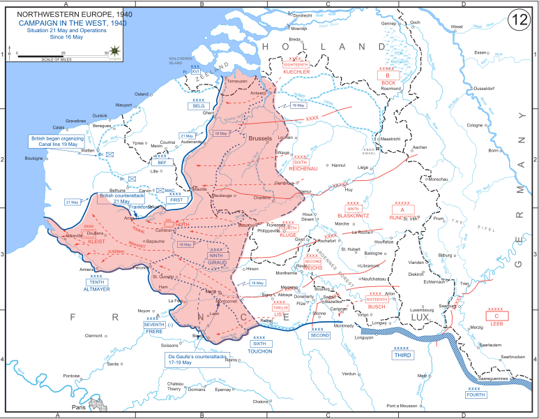
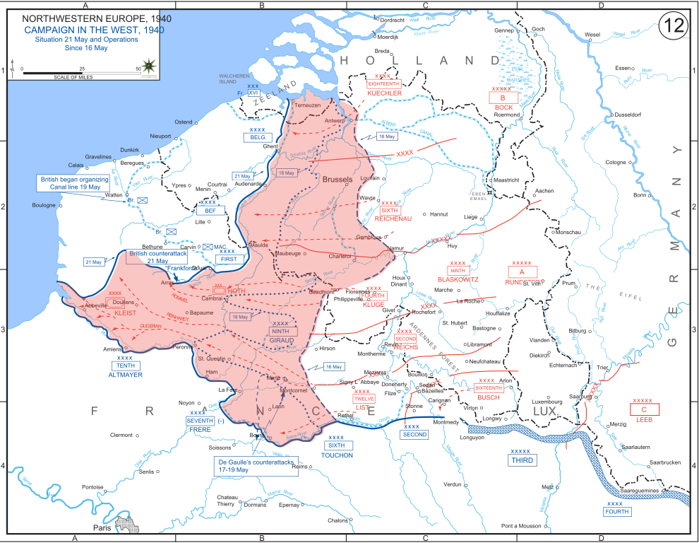
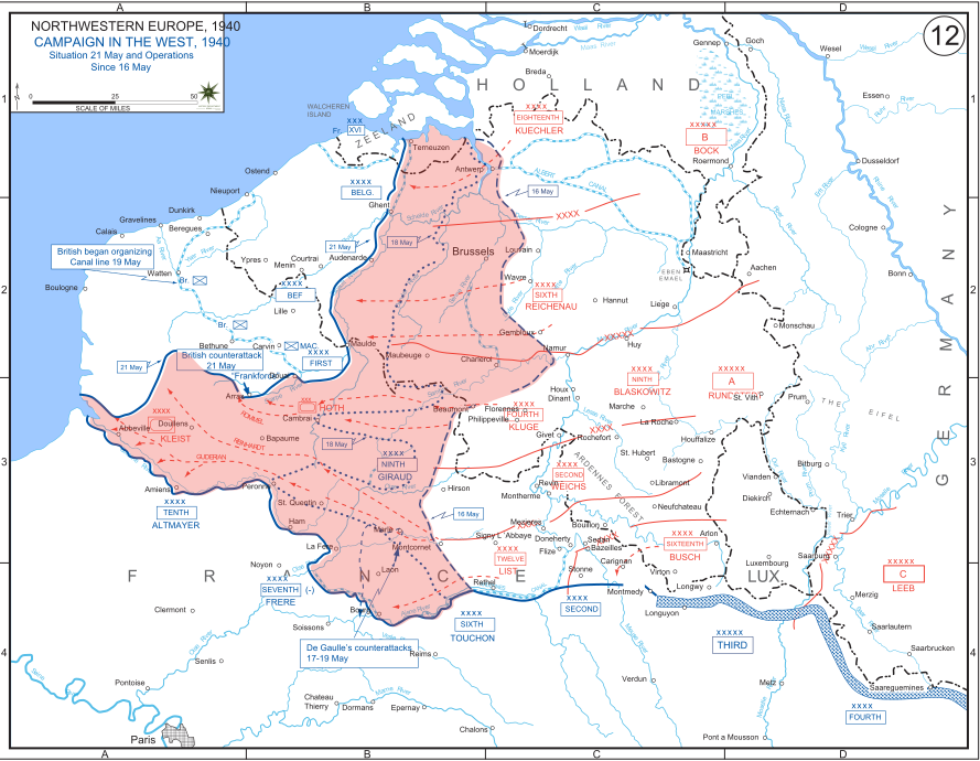
English: The German advance between 16 May and 21 May 1940. The red area denotes the territory captured by Germany during this time. The German field armies and Corps are shown in red. The operating area of the various Belgian, British, and French field armies and Army groups are shown in blue. The checkered white and blue area denotes the French Maginot Line. The commanders of the various units are shown under their respective formation. Solid lines represent the boundaries between each major unit. Dotted lines depict lines of advance. Key dates are shown in boxes. |
| Датум | |
| Извор | Archive link to original website used for the map and the archive link to the map source page. Current link to map, and link to map source page. |
| Аутор | The History Department of the United States Military Academy |
| Остале верзије |
|


Лиценцирање
Ова датотека је рад припадника Америчке војске или особе запослене у њој и начињена је за време обављања дужности те особе. Као рад америчке савезне владе, ова датотека је у јавном власништву у САД-у.
|
 |
Историја датотеке
Кликните на датум/време да бисте видели тадашњу верзију датотеке.
| Датум/време | Минијатура | Димензије | Корисник | Коментар | |
|---|---|---|---|---|---|
| тренутна | 21:07, 29. децембар 2011. | | 889 × 690 (2,06 MB) | Zscout370 | The text was displaying oddly in this SVG. |
| 21:07, 29. децембар 2011. |  | 889 × 690 (463 kB) | Addihockey10 | test | |
| 04:58, 24. септембар 2010. |  | 889 × 690 (334 kB) | Tazadeperla | {{Information |Description={{en|1=Vector version of file 1940FranceBlitz.jpg}} |Source=http://www.dean.usma.edu/history/web03/atlases/ww2%20europe/WWIIEuropeIndex.html |Author=The History Dept at the United States Army Academy |Date= |Permission= |other_v |
Употреба датотеке
Следећа страница користи ову датотеку:
Глобална употреба датотеке
Други викији који користе ову датотеку:
- Употреба на af.wikipedia.org
- Употреба на ar.wikipedia.org
- Употреба на azb.wikipedia.org
- Употреба на bn.wikipedia.org
- Употреба на br.wikipedia.org
- Употреба на bs.wikipedia.org
- Употреба на ca.wikipedia.org
- Употреба на cs.wikipedia.org
- Употреба на da.wikipedia.org
- Употреба на en.wikipedia.org
- Употреба на fi.wikipedia.org
- Употреба на fr.wikipedia.org
- Употреба на gl.wikipedia.org
- Употреба на he.wikipedia.org
- Употреба на id.wikipedia.org
- Употреба на it.wikipedia.org
- Употреба на ja.wikipedia.org
- Употреба на ko.wikipedia.org
- Употреба на lt.wikipedia.org
- Употреба на lv.wikipedia.org
- Употреба на nl.wikipedia.org
- Употреба на no.wikipedia.org
- Употреба на pl.wikipedia.org
- Употреба на pt.wikipedia.org
- Употреба на ro.wikipedia.org
- Употреба на ru.wikipedia.org
- Употреба на simple.wikipedia.org
- Употреба на sl.wikipedia.org
- Употреба на th.wikipedia.org
Још глобалног коришћења ове датотеке.