Датотека:Abu Reyhan Biruni-Earth Circumference.svg

Оригинална датотека (SVG датотека, номинално 1.000 × 900 пиксела, величина: 16 kB)
| Ово је датотека са Викимедијине оставе. Информације са њене странице са описом приказане су испод. Викимедијина остава је складиште слободно лиценциралних мултимедијалних датотека. И Ви можете да помогнете. |
Опис измене
| Опис |
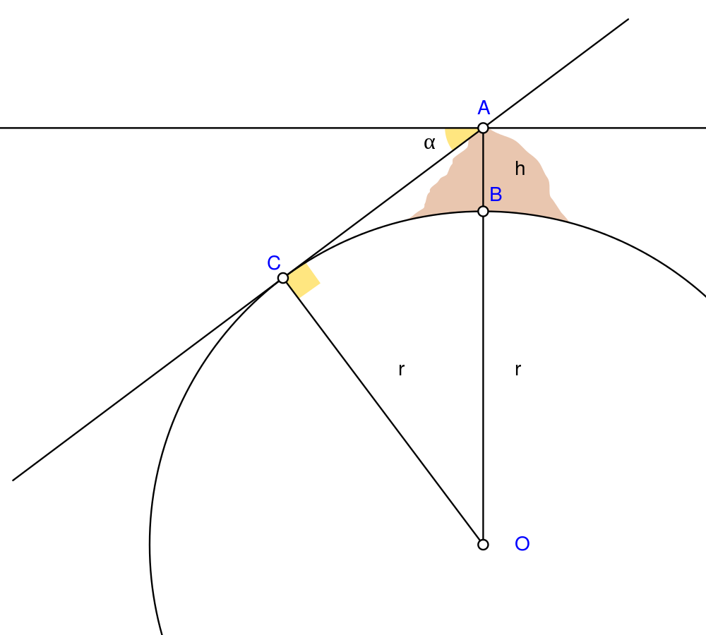
English: Biruni (973 - 1048) developed a new method using trigonometric calculations to compute earth's radius and circumference based on the angle between the horizontal line and true horizon from a mountain top with known height. He calculated the height of the mountain by going to two points at sea level with a known distance apart and then measuring the angle between the plain and the top of the mountain for both points.
Biruni's estimate of 6,339.9 km for the Earth radius had an error of 0.0026 and was 16.8 km less than the current value of 6,356.7 km. The idea came to him when he was on top of a tall mountain near Nandana in Pakistan. He measured the dip angle using an astrolabe and he applied to the law of sines formula. He also made use of algebra in his calculation.
Solution: Français : Biruni (973-1048) développa une nouvelle méthode utilisant la trigonométrie pour calculer le rayon et la ciconférence de la Terre, basée sur l'angle entre la ligne horizontale et l'horizon réel depuis le sommet d'une montagne de hauteur connue. Il calcula la hauteur de la montagne en se rendant en deux points situés au niveau de la mer dont l'écartement était connu, puis en mesurant l'angle entre la ligne horizontale formée par les deux points au niveau de la mer et le sommet de la montagne, et ceci depuis chacun des deux points.
L'estimation de Biruni de 6 339,9 km pour le rayon de la Terre comportait une erreur de 0,26 %, soit une valeur inférieure de 16,8 km par rapport à la valeur actuelle de 6 356,7 km. L'idée lui était venue alors qu'il se trouvait au sommet d'une haute montagne, près de Nandana en Inde. Il mesura l'angle d'incinaison avec un astrolabe et il appliqua la formule des sinus. Il fit également usage de l'algèbre pour ses calculs.
Solution : |
| Датум | |
| Извор | Сопствено дело Using Geogebra and Inkscape |
| Аутор | Nevit Dilmen |
| SVG genesis | and with GeoGebra. |
Лиценцирање
- Дозвољено је:
- да делите – да умножавате, расподељујете и преносите дело
- да прерађујете – да прерадите дело
- Под следећим условима:
- ауторство – Морате да дате одговарајуће заслуге, обезбедите везу ка лиценци и назначите да ли су измене направљене. Можете то урадити на било који разуман манир, али не на начин који предлаже да лиценцатор одобрава вас или ваше коришћење.
- делити под истим условима – Ако измените, преобразите или доградите овај материјал, морате поделити своје доприносе под истом или компатибилном лиценцом као оригинал.
Историја датотеке
Кликните на датум/време да бисте видели тадашњу верзију датотеке.
| Датум/време | Минијатура | Димензије | Корисник | Коментар | |
|---|---|---|---|---|---|
| тренутна | 07:25, 2. мај 2010. | | 1.000 × 900 (16 kB) | Nevit | Crop |
| 07:21, 2. мај 2010. |  | 1.390 × 1.220 (16 kB) | Nevit | Yellow removed | |
| 07:19, 2. мај 2010. |  | 1.390 × 1.220 (16 kB) | Nevit | Image version | |
| 07:18, 2. мај 2010. |  | 640 × 480 (22 kB) | Nevit | {{Information |Description={{en|1=Biruni (973 - 1048) developed a new method using trigonometric calculations to compute earth's circumference based on the angle between the horizontal line and true horizon from a mountain top with known height. He calcu |
Употреба датотеке
Следећа страница користи ову датотеку:
Глобална употреба датотеке
Други викији који користе ову датотеку:
- Употреба на af.wikipedia.org
- Употреба на ar.wikipedia.org
- Употреба на bcl.wikipedia.org
- Употреба на bn.wikipedia.org
- Употреба на bs.wikipedia.org
- Употреба на diq.wikipedia.org
- Употреба на en.wikipedia.org
- Употреба на es.wikipedia.org
- Употреба на fa.wikipedia.org
- Употреба на fr.wikipedia.org
- Употреба на he.wikipedia.org
- Употреба на hr.wikipedia.org
- Употреба на id.wikipedia.org
- Употреба на it.wikipedia.org
- Употреба на ja.wikipedia.org
- Употреба на ps.wikipedia.org
- Употреба на pt.wikipedia.org
- Употреба на pt.wikibooks.org
- Употреба на ro.wikipedia.org
- Употреба на ru.wikipedia.org
- Употреба на sd.wikipedia.org
- Употреба на sh.wikipedia.org
- Употреба на ta.wikipedia.org
- Употреба на tr.wikipedia.org
- Употреба на tt.wikipedia.org
- Употреба на uk.wikipedia.org
- Употреба на uz.wikipedia.org
- Употреба на www.wikidata.org
Још глобалног коришћења ове датотеке.