Датотека:Adygea districts.png

Величина овог приказа: 785 × 600 пиксела. 3 друге резолуције: 314 × 240 пиксела | 628 × 480 пиксела | 1.013 × 774 пиксела.
Оригинална датотека (1.013 × 774 пиксела, величина датотеке: 56 kB, MIME тип: image/png)
| Ово је датотека са Викимедијине оставе. Информације са њене странице са описом приказане су испод. Викимедијина остава је складиште слободно лиценциралних мултимедијалних датотека. И Ви можете да помогнете. |
Опис измене
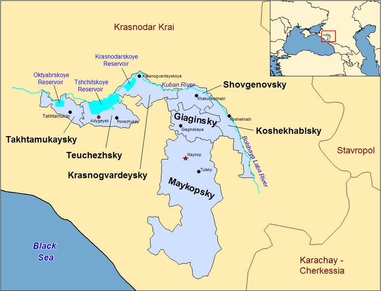
| Опис | Map of the districts of the Adygea republic of Russia. Created by Rarelibra 13:10, 30 March 2007 (UTC) for public domain use, using MapInfo Professional v8.5 and various mapping resources. |
| Датум | 30. март 2007. (првобитни датум слања) |
| Извор | No machine-readable source provided. Own work assumed (based on copyright claims). |
| Аутор | No machine-readable author provided. Rarelibra assumed (based on copyright claims). |
Previous summary and history (en.wikipedia)
Map of the districts of the Republic of Adygea (federal subject of Russia). Created by Rarelibra 20:52, 20 December 2006 (UTC) for public domain use, using MapInfo Professional v8.5 and various mapping resources. Special thanks to w:User:Ezhiki for both his patience and input to help complete this map for his wiki project.
- 16:06, April 3, 2007 . . Rarelibra (Talk | contribs | block) . . 1056×816 (58,397 bytes) (Updated version)
- 17:35, March 27, 2007 . . Rarelibra (Talk | contribs | block) . . 823×752 (50,852 bytes) (Updated map)
- 22:34, December 20, 2006 . . Rarelibra (Talk | contribs | block) . . 1281×878 (48,913 bytes) (Map of the districts of the Republic of Adygea (a federal subject of Russia). Created by ~~~~ for public domain use with attribution under GNU. Created using MapInfo Professional v8.5 and various mapping resources. Special thanks to User:Ezhiki for hi)
- 20:52, December 20, 2006 . . Rarelibra (Talk | contribs | block) . . 1281×878 (43,557 bytes) (Map of the districts of the Republic of Adygea (federal subject of Russia). Created by ~~~~ for public domain use, using MapInfo Professional v8.5 and various mapping resources. Special thanks to User:Ezhiki for both his patience and input to help com)
Лиценцирање
| Ја, творац овог дела, предајем га у јавно власништво. Ово се односи на цео свет. У неким земљама, ово није законски могуће; у том случају: Ја, творац овог дела дозвољавам свакоме да користи ово дело за било коју намену, без било каквих услова, осим услова које намеће закон. |
Историја датотеке
Кликните на датум/време да бисте видели тадашњу верзију датотеке.
| Датум/време | Минијатура | Димензије | Корисник | Коментар | |
|---|---|---|---|---|---|
| тренутна | 00:53, 1. јануар 2024. | | 1.013 × 774 (56 kB) | User-duck | Cropped border using CropTool with lossless mode. |
| 15:18, 23. април 2007. |  | 1.056 × 816 (57 kB) | Rarelibra | Reverted to earlier revision | |
| 17:54, 21. април 2007. |  | 1.056 × 816 (46 kB) | David Kernow~commonswiki | ||
| 18:04, 3. април 2007. |  | 1.056 × 816 (57 kB) | Rarelibra | Updated version | |
| 15:10, 30. март 2007. |  | 823 × 752 (50 kB) | Rarelibra | Map of the districts of the Adygea republic of Russia. Created by ~~~~ for public domain use, using MapInfo Professional v8.5 and various mapping resources. |
Употреба датотеке
Нема страница које користе ову датотеку.
Глобална употреба датотеке
Други викији који користе ову датотеку:
- Употреба на af.wikipedia.org
- Употреба на azb.wikipedia.org
- Употреба на ca.wikipedia.org
- Употреба на cy.wikipedia.org
- Употреба на de.wikipedia.org
- Употреба на el.wikipedia.org
- Употреба на en.wikipedia.org
- Употреба на fa.wikipedia.org
- Употреба на fi.wikipedia.org
- Употреба на frr.wikipedia.org
- Употреба на fr.wikipedia.org
- Употреба на incubator.wikimedia.org
- Употреба на io.wikipedia.org
- Употреба на it.wikipedia.org
- Употреба на krc.wikipedia.org
- Употреба на lv.wikipedia.org
- Употреба на mn.wikipedia.org
- Употреба на nl.wikipedia.org
- Употреба на pl.wikipedia.org
- Употреба на pl.wiktionary.org
- Употреба на pt.wikipedia.org
- Употреба на ru.wikivoyage.org