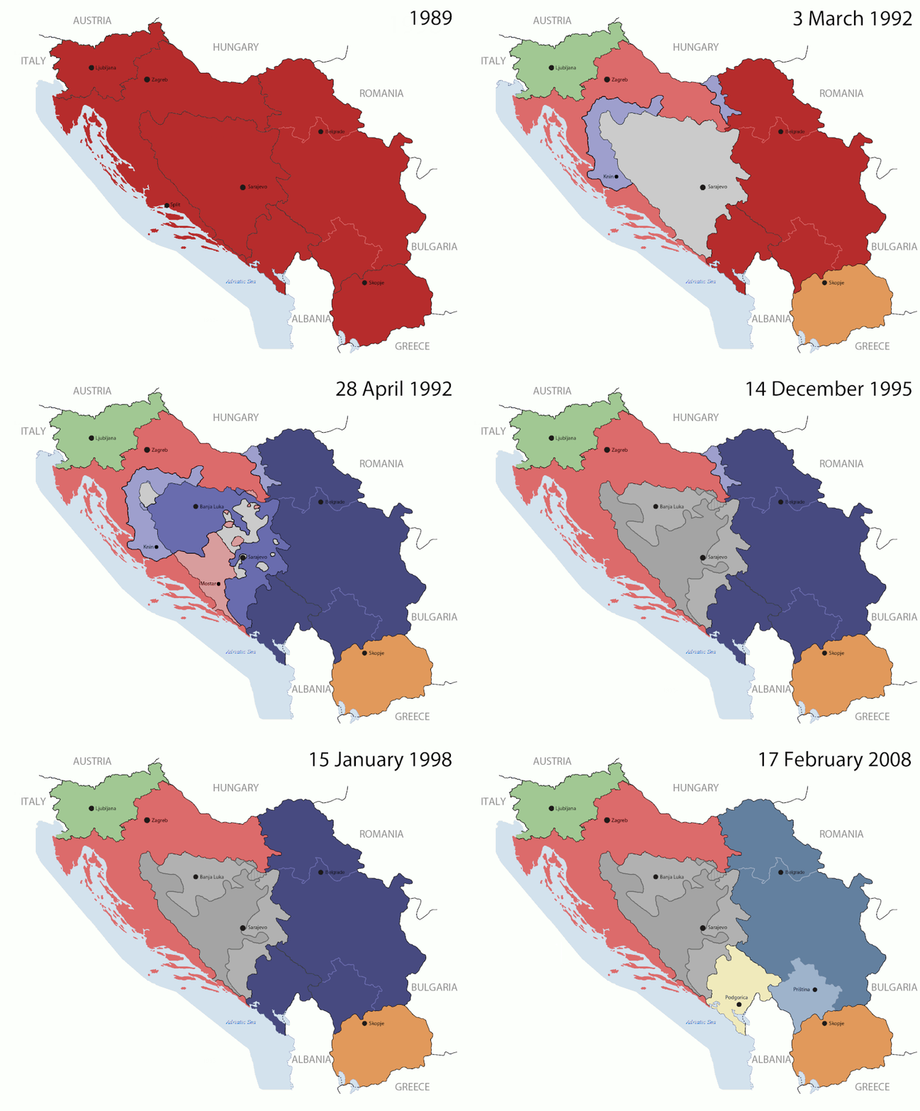
Оригинална датотека(1.545 × 1.242 пиксела, величина датотеке: 187 kB, MIME тип: image/gif, петља, 14 кадрова, 44 с)

This image could be re-created using vector graphics as an SVG file. This has several advantages; see Commons:Media for cleanup for more information. If an SVG form of this image is available, please upload it and afterwards replace this template with {{vector version available|new image name}}. It is recommended to name the SVG file "Breakup of Yugoslavia.svg" - then the template Vector version available (or Vva) does not need the new image name parameter.

Опис измене

Key:

Yugoslavia (1943–1992) SFR Yugoslavia
Croatia (1991–present) Croatia
Herzeg-Bosnia (1992–1994)
UNTAES (1996–1998)
Federal Republic of Yugoslavia / Serbia and Montenegro (1992–2006) Serbia and Montenegro
Republika Srpska (1992–present) Republika Srpska
Serbian Krajina (1991–1995/96)
Republic of Bosnia and Herzegovina (1992–1995)
Bosnia and Herzegovina (1998–present) Bosnia and Herzegovina
Western Bosnia (1993–1995)
Serbia (2006–present) Serbia
Kosovo (under UNMIK control 1999–present; declaration of independence 2008) Kosovo
Montenegro (2006–present) Montenegro
Macedonia (1991–present) Macedonia
Slovenia (1991–present) Slovenia


Опис

This is an animated GIF that shows the stages of the breakup of the SFR Yugoslavia in the 90's and 2000's. The map based off Morwen's map of the divisions of the SFRY, Which is licensed by the GFDL. The source for the dates of independence is the CIA World Factbook. These maps do not now show the Inter-Entity Boundary Line (IEBL) and/or the entities that are separated by it. The IEBL has been drawn based on this CIA map; the Brčko District has been drawn based on Image:BH municipality location.gif, by user:Ante Perkovic. I might add them in the future.

Since the original map was GFDL, this image is as well.

A map depicting Kosovo's final status is ready once it takes effect.


Changelog for versions 2/3:

Here are some changes in this new build of the map:

  • The Kosovo boundary has been given a shade of red instead of the previous UN blue since they are a province of Serbia under UNIMIK control.
  • Montenegro's color has been changed to a golden shade close to what's on the flag.
  • The IEBL and the Brčko District has been redrawn because I deleted the original map; the color for the Republika Srpska is lighter.
  • The dates are at the top left hand corner of the map instead of the bottom.
  • I have taken a new approach as to the boundaries. Each part of Yugoslavia now shows the boundary on the maps starting the year they broke away. I feel this change helps readers understand the breakup better.
  • The SFRY and the FRY are in different shades since the FRY was never accepted as the successor to the former by the UN.
  • The colors for the entities of BiH have been removed as to not confuse people into thinking that they are independent states. What remains is the IEBL with both entities in green.
  • The Kosovo boundary is finally in hash marks!
  • The Brčko District has been removed. The sale is too small to show accurately.

Changelog for version 4:

  • The map is larger!
  • The image has been rebuilt to include the eastern part of FYR Macedonia.
  • The image has been updated to take in Kosovo's new status.
  • The IEBL is now a darker line.
  • Montenegro, Kosovo, and FRY/SCG/Serbia have new colors!

Changelog for version 5:

  • Rebuilt
  • Larger map: size of base image
  • Accurate Inter-Entity Boundary Line
Датум 24 July 2006 (orginal upload date)
Извор Made by Hoshie; see above for more details on sources.
Аутор Hoshie
Остале верзије

Лиценцирање

GNU head Дата је дозвола да се копира, дистрибуира и/или мења овај документ под условима ГНУ-ове лиценце за слободну документацију, верзије 1.2 или било које новије верзије коју објави Задужбина за слободни софтвер; без непроменљивих одељака и без текста на насловној и задњој страни. Текст лиценце можете прочитати овде.
w:sr:Creative Commons
ауторство делити под истим условима
Ова датотека је доступна под лиценцом Creative Commons Ауторство-Делити под истим условима 3.0 Unported.
Дозвољено је:
  • да делите – да умножавате, расподељујете и преносите дело
  • да прерађујете – да прерадите дело
Под следећим условима:
  • ауторство – Морате да дате одговарајуће заслуге, обезбедите везу ка лиценци и назначите да ли су измене направљене. Можете то урадити на било који разуман манир, али не на начин који предлаже да лиценцатор одобрава вас или ваше коришћење.
  • делити под истим условима – Ако измените, преобразите или доградите овај материјал, морате поделити своје доприносе под истом или компатибилном лиценцом као оригинал.
Ова лиценца је додата на ову датотеку као део ажурирања GFDL лиценце.

Натписи

Укратко шта ова датотека представља/приказује

Ставке приказане у овој датотеци

приказује

Нека вредност без ставке на Википодаци

05ca2aefea8406b809968643552d5095c847a42f

44 секунда

1.242 пиксел

1.545 пиксел

Историја датотеке

Кликните на датум/време да бисте видели тадашњу верзију датотеке.

(најновије | најстарије) Прикажи (новијих 10 | ) (10 | 20 | 50 | 100 | 250 | 500).
Датум/времеМинијатураДимензијеКорисникКоментар
тренутна09:40, 17. јул 2016.Минијатура за верзију на дан 09:40, 17. јул 2016.1.545 × 1.242 (187 kB)מפתח-רשימהReverted to version as of 17:22, 21 August 2015 (UTC)
19:22, 21. август 2015.Минијатура за верзију на дан 19:22, 21. август 2015.1.463 × 1.158 (1,81 MB)BraganzaReverted to version as of 03:57, 19 January 2010
19:22, 21. август 2015.Минијатура за верзију на дан 19:22, 21. август 2015.1.545 × 1.242 (187 kB)BraganzaReverted to version as of 01:02, 19 December 2011
19:15, 21. август 2015.Минијатура за верзију на дан 19:15, 21. август 2015.120 × 95 (3 kB)Braganza03:57, 19. Jan. 2010
03:02, 19. децембар 2011.Минијатура за верзију на дан 03:02, 19. децембар 2011.1.545 × 1.242 (187 kB)DIREKTORAdded details
20:09, 27. јул 2011.Минијатура за верзију на дан 20:09, 27. јул 2011.1.545 × 1.242 (170 kB)DIREKTORSmall fixes
19:28, 27. јул 2011.Минијатура за верзију на дан 19:28, 27. јул 2011.1.545 × 1.242 (171 kB)DIREKTORAdded UNMIK
18:38, 27. јул 2011.Минијатура за верзију на дан 18:38, 27. јул 2011.1.545 × 1.242 (165 kB)DIREKTORDates for the last two frames.
14:10, 27. јул 2011.Минијатура за верзију на дан 14:10, 27. јул 2011.1.545 × 1.242 (149 kB)DIREKTORLighter shade for country names
18:59, 26. јул 2011.Минијатура за верзију на дан 18:59, 26. јул 2011.1.545 × 1.242 (170 kB)DIREKTORHigher res plus details
(најновије | најстарије) Прикажи (новијих 10 | ) (10 | 20 | 50 | 100 | 250 | 500).

2 следеће странице користе ову датотеку:

Глобална употреба датотеке

Други викији који користе ову датотеку:

Још глобалног коришћења ове датотеке.

Метаподаци