Датотека:Chugwater Soda Fountain.jpg

Оригинална датотека (4.000 × 3.000 пиксела, величина датотеке: 2,66 MB, MIME тип: image/jpeg)
| Ово је датотека са Викимедијине оставе. Информације са њене странице са описом приказане су испод. Викимедијина остава је складиште слободно лиценциралних мултимедијалних датотека. И Ви можете да помогнете. |
Опис измене
| Опис |
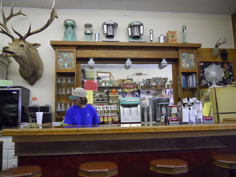
The History of the Chugwater Soda Fountain The Oldest Operating Soda fountain in Wyoming The Soda fountain is housed in one of the oldest buildings in Chugwater. The building was built in 1914, later, partially burned down, and was rebuilt in 1916. It has been a Doctor's office and a pharmacy. There was a small apartment in the back where the doctor and his family lived. The pharmacy drawers are still intact along one wall of the store. The soda fountain bar was built in England and installed in a business in Rock Creek WY. when the Railroad went through in 1927, the town moved to Tock River. The owner was not interested in moving his business, so he sold his equipment to the owner of the pharmacy in Chugwater. The bar was broken aprt into three pieces - the main bar, the top(including the mirror), and the bottom cabinets. It was then packed into wagons and transported over the mountains to be installed in this building. The mirror and glass are all original; you can stand in the back and see the curve in the mirror.1 The pharmacy and soda fountain co-existed for some time, but eventually one of the owners no longer had a pharmacy license and the store became a soda fountain only. Ownership has changed hands many times, with different people making various changes. The large elk overlooking the room is nicknamed "Wendall" for the man who shot him. He was shot near Jackson, WY in 1946 and has resided in the soda fountain since 1947. A town petition prevents Wendall from leaving, no matter who owns it. Over time, different owners have added components like the small package liquor store, "diner", and the Beer Garden in the summer. It remains one of few active soda fountains in the state that serves traditional, hand dipped ice cream shakes and malts. |
| Датум | |
| Извор | Chugwater Soda Fountain |
| Аутор | Konrad Summers from Santa Clarita (Valencia) , California, USA |
| Положај камере | | Ова и друге слике снимљене у близини на: OpenStreetMap |
|---|
Лиценцирање
- Дозвољено је:
- да делите – да умножавате, расподељујете и преносите дело
- да прерађујете – да прерадите дело
- Под следећим условима:
- ауторство – Морате да дате одговарајуће заслуге, обезбедите везу ка лиценци и назначите да ли су измене направљене. Можете то урадити на било који разуман манир, али не на начин који предлаже да лиценцатор одобрава вас или ваше коришћење.
- делити под истим условима – Ако измените, преобразите или доградите овај материјал, морате поделити своје доприносе под истом или компатибилном лиценцом као оригинал.
| This image was originally posted to Flickr by tkksummers at https://www.flickr.com/photos/12806074@N08/4712851275. It was reviewed on 14. јул 2015. by FlickreviewR and was confirmed to be licensed under the terms of the cc-by-sa-2.0. |
Историја датотеке
Кликните на датум/време да бисте видели тадашњу верзију датотеке.
| Датум/време | Минијатура | Димензије | Корисник | Коментар | |
|---|---|---|---|---|---|
| тренутна | 23:22, 14. јул 2015. | | 4.000 × 3.000 (2,66 MB) | Tillman | Transferred from Flickr via Flickr2Commons |
Употреба датотеке
Следећа страница користи ову датотеку:
Глобална употреба датотеке
Други викији који користе ову датотеку:
- Употреба на azb.wikipedia.org
- Употреба на de.wikipedia.org
- Употреба на en.wikipedia.org
- Употреба на fa.wikipedia.org
- Употреба на fr.wikipedia.org
- Употреба на pt.wikipedia.org
- Употреба на uk.wikipedia.org
- Употреба на zh-min-nan.wikipedia.org