Датотека:Courthouse Square as seen from Court Street Bridge, Owego, New York - 20220206.jpg

Величина овог приказа: 800 × 480 пиксела. 5 других резолуција: 320 × 192 пиксела | 1.024 × 614 пиксела | 1.280 × 768 пиксела | 2.560 × 1.536 пиксела | 3.715 × 2.229 пиксела.
Оригинална датотека (3.715 × 2.229 пиксела, величина датотеке: 2,07 MB, MIME тип: image/jpeg)
| Ово је датотека са Викимедијине оставе. Информације са њене странице са описом приказане су испод. Викимедијина остава је складиште слободно лиценциралних мултимедијалних датотека. И Ви можете да помогнете. |
Опис измене
| Опис |
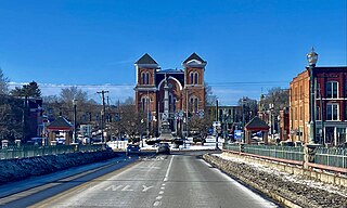
English: Courthouse Square in central Owego, New York, as seen from near the crest of the Court Street Bridge over the Susquehanna River on a February 2022 evening. The square has been the site of a public park dating back to 1797, only a few years after the village's incorporation, and it's today the central node of the historic downtown. In 1871, about half of the park was reclaimed by the municipal government to serve as the home of the Tioga County Courthouse, which was completed the following year to a design by locally-based architect Miles F. Howe and is seen at center in the photograph. Unusually for the Second Empire style, bluntly pointed arches are a recurring motif: you see them not only on the prominent limestone window heads above the double arched windows on the three-story towers that delineate the building's four corners, but also crowning the façade itself in the form of a raking cornice undergirded by block modillions. Even more unusual is the absence of a mansard roof, ordinarily the style's defining feature. The entrance, not visible from this perspective, is framed consecutively by a round arch of cut limestone and a shallow tetrastyle portico with stylized Corinthian pillars. The interior, too, is architecturally notable for its fine-quality woodwork, including chestnut wainscoting on the walls as well as window frames and furnishings in black walnut. In front rises the Tioga County Memorial, a 50-foot shaft of Barre granite crowned and flanked by depictions of Civil War soldiers and sailors, erected in 1890 to the memory of the local "heroes who fought, and martyrs who fell, that the Union might live". |
| Датум | |
| Извор | Сопствено дело |
| Аутор | Andre Carrotflower |
| Положај камере | | Ова и друге слике снимљене у близини на: OpenStreetMap |
|---|
Лиценцирање
Ја, носилац ауторског права над овим делом, објављујем исто под следећом лиценцом:
Ова датотека је доступна под лиценцом Creative Commons Ауторство-Делити под истим условима 4.0 међународна.
- Дозвољено је:
- да делите – да умножавате, расподељујете и преносите дело
- да прерађујете – да прерадите дело
- Под следећим условима:
- ауторство – Морате да дате одговарајуће заслуге, обезбедите везу ка лиценци и назначите да ли су измене направљене. Можете то урадити на било који разуман манир, али не на начин који предлаже да лиценцатор одобрава вас или ваше коришћење.
- делити под истим условима – Ако измените, преобразите или доградите овај материјал, морате поделити своје доприносе под истом или компатибилном лиценцом као оригинал.
Историја датотеке
Кликните на датум/време да бисте видели тадашњу верзију датотеке.
| Датум/време | Минијатура | Димензије | Корисник | Коментар | |
|---|---|---|---|---|---|
| тренутна | 04:33, 14. фебруар 2022. | | 3.715 × 2.229 (2,07 MB) | Andre Carrotflower | Uploaded own work with UploadWizard |
Употреба датотеке
Следећа страница користи ову датотеку:
Глобална употреба датотеке
Други викији који користе ову датотеку:
- Употреба на en.wikipedia.org
- Употреба на es.wikipedia.org