Датотека:First Republic of Armenia in 1918-1920.png

Величина овог приказа: 799 × 348 пиксела. 6 других резолуција: 320 × 139 пиксела | 640 × 279 пиксела | 1.024 × 446 пиксела | 1.280 × 558 пиксела | 2.560 × 1.115 пиксела | 8.192 × 3.568 пиксела.
Оригинална датотека (8.192 × 3.568 пиксела, величина датотеке: 14,85 MB, MIME тип: image/png)
| Ово је датотека са Викимедијине оставе. Информације са њене странице са описом приказане су испод. Викимедијина остава је складиште слободно лиценциралних мултимедијалних датотека. И Ви можете да помогнете. |
Опис измене
| Опис |
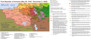
English: The First Republic of Armenia in 1918-1920. |
| Датум | |
| Извор | Сопствено дело |
| Аутор | Accipite7 |
Лиценцирање
Ја, носилац ауторског права над овим делом, објављујем исто под следећом лиценцом:
Ова датотека је доступна под лиценцом Creative Commons Ауторство-Делити под истим условима 4.0 међународна.
- Дозвољено је:
- да делите – да умножавате, расподељујете и преносите дело
- да прерађујете – да прерадите дело
- Под следећим условима:
- ауторство – Морате да дате одговарајуће заслуге, обезбедите везу ка лиценци и назначите да ли су измене направљене. Можете то урадити на било који разуман манир, али не на начин који предлаже да лиценцатор одобрава вас или ваше коришћење.
- делити под истим условима – Ако измените, преобразите или доградите овај материјал, морате поделити своје доприносе под истом или компатибилном лиценцом као оригинал.
Историја датотеке
Кликните на датум/време да бисте видели тадашњу верзију датотеке.
| Датум/време | Минијатура | Димензије | Корисник | Коментар | |
|---|---|---|---|---|---|
| тренутна | 17:13, 2. јун 2021. | | 8.192 × 3.568 (14,85 MB) | Accipite7 | for the convenience of viewing small details, the size is increased, the colors are improved |
| 10:17, 25. мај 2021. |  | 4.096 × 1.784 (3,69 MB) | Accipite7 | The border between Nahang of Shirak and Nahang of Syunik has been clarified. | |
| 11:59, 21. мај 2021. |  | 4.096 × 1.784 (3,7 MB) | Accipite7 | The temporary border between the Republic of Armenia and the Soviet republics (August 10, 1920) in the Nakhichevan county has been clarified. Added a legend marked on the map under the number 26. | |
| 10:35, 13. мај 2021. |  | 4.096 × 1.784 (3,97 MB) | Accipite7 | fixed typo | |
| 10:27, 13. мај 2021. |  | 4.096 × 1.784 (3,97 MB) | Accipite7 | The names of the types of administrative units of the former Russian Empire have been clarified: uyezd = county, okrug = district, oblast = territory, guberniya = governorate. | |
| 13:14, 12. мај 2021. |  | 4.096 × 1.784 (3,71 MB) | Accipite7 | Corrected data in the map legend regarding what is indicated on the map by numbers. Clarified the boundaries of the territories required at the Paris Peace Conference. I strongly ask the user of Culminatio not to vandalize and not return the map to the version on which he marked the line reached as a result of the Turkish offensive in 1920. Since, firstly, it is neural: Batumi, Artvin and Ardahan were under the control of the Democratic Republic of Georgia until February-March 1921. And secon... | |
| 06:13, 12. мај 2021. |  | 5.375 × 2.341 (7,18 MB) | Culminatio | Reverted to version as of 15:05, 8 May 2021 (UTC) | |
| 09:11, 11. мај 2021. |  | 4.096 × 1.784 (3,99 MB) | Accipite7 | The boundaries of the territory of the demands of the Armenian delegation in the Transcaucasus, submitted to the Paris Peace Conference of 1919, were clarified. There is no need to overload the map with the line reached by the Turkish forces in 1920, as the map already shows the results of the Armenian-Turkish war of 1920 - the border according to the Treaty of Alexandropol, December 2, 1920 | |
| 17:05, 8. мај 2021. |  | 5.375 × 2.341 (7,18 MB) | Culminatio | Additional line of the turkish advance on the northern positions during the war of 1920. Additional numbers 10,19,20,21 on the map. | |
| 12:49, 8. мај 2021. |  | 6.336 × 2.760 (2,21 MB) | Accipite7 | Improved colors. |
Употреба датотеке
Следећа страница користи ову датотеку:
Глобална употреба датотеке
Други викији који користе ову датотеку:
- Употреба на az.wikipedia.org
- Употреба на be.wikipedia.org
- Употреба на bg.wikipedia.org
- Употреба на de.wikipedia.org
- Употреба на el.wikipedia.org
- Употреба на fi.wikipedia.org
- Употреба на fr.wikipedia.org
- Употреба на hy.wikipedia.org
- Употреба на it.wikipedia.org
- Употреба на nl.wikipedia.org
- Употреба на pl.wikipedia.org
- Употреба на pt.wikipedia.org
- Употреба на ro.wikipedia.org
- Употреба на ru.wikipedia.org
- Употреба на uk.wikipedia.org
- Употреба на zh.wikipedia.org