Датотека:South Williamson Kentucky aerial view.jpg

Величина овог приказа: 800 × 534 пиксела. 4 друге резолуције: 320 × 214 пиксела | 640 × 427 пиксела | 1.024 × 683 пиксела | 1.500 × 1.001 пиксела.
Оригинална датотека (1.500 × 1.001 пиксела, величина датотеке: 814 kB, MIME тип: image/jpeg)
| Ово је датотека са Викимедијине оставе. Информације са њене странице са описом приказане су испод. Викимедијина остава је складиште слободно лиценциралних мултимедијалних датотека. И Ви можете да помогнете. |
| Опис |
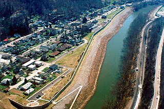
English: Aerial view of South Williamson, Kentucky, USA. The town is protected by a floodwall built along the Tug Fork River by the U.S. Army Corps of Engineers. The river here is the border between Kentucky and West Virginia. The view in this photograph is from the West Virginia side looking south-southwest over the river to South Williamson, Kentucky. |
|||
| Локација | South Williamson, Kentucky, USA 37°40′20.97″N 82°17′4.92″W / 37.6724917°N 82.2847°W |
|||
| Датум | ||||
| Извор |
U.S. Army Corps of Engineers Digital Visual Library Image page Image description page Digital Visual Library home page |
|||
| Аутор | U.S. Army Corps of Engineers, photographer not specified or unknown | |||
| Дозвола (Поновно коришћење ове датотеке) |
|
Историја датотеке
Кликните на датум/време да бисте видели тадашњу верзију датотеке.
| Датум/време | Минијатура | Димензије | Корисник | Коментар | |
|---|---|---|---|---|---|
| тренутна | 03:21, 22. март 2007. | | 1.500 × 1.001 (814 kB) | DanMS | {{Information | Description = {{en|Aerial view of South Williamson, Kentucky, USA. The town is protected by a floodwall built along the Tug Fork River by the U.S. Army Corps of Engineers.}} | Source = U.S. Army Corps of Engineers Digital Visual |
Употреба датотеке
Следећа страница користи ову датотеку:
Глобална употреба датотеке
Други викији који користе ову датотеку:
- Употреба на azb.wikipedia.org
- Употреба на ceb.wikipedia.org
- Употреба на ce.wikipedia.org
- Употреба на en.wikipedia.org
- Употреба на es.wikipedia.org
- Употреба на fa.wikipedia.org
- Употреба на lld.wikipedia.org
- Употреба на pl.wikipedia.org
- Употреба на tt.wikipedia.org
- Употреба на uk.wikipedia.org
- Употреба на www.wikidata.org
- Употреба на zh.wikipedia.org