Датотека:Tassili n’Ajjer National Park NASA Landsat 7 (2000).jpg

Оригинална датотека (6.357 × 4.869 пиксела, величина датотеке: 9,31 MB, MIME тип: image/jpeg)
| Ово је датотека са Викимедијине оставе. Информације са њене странице са описом приказане су испод. Викимедијина остава је складиште слободно лиценциралних мултимедијалних датотека. И Ви можете да помогнете. |
| Опис |
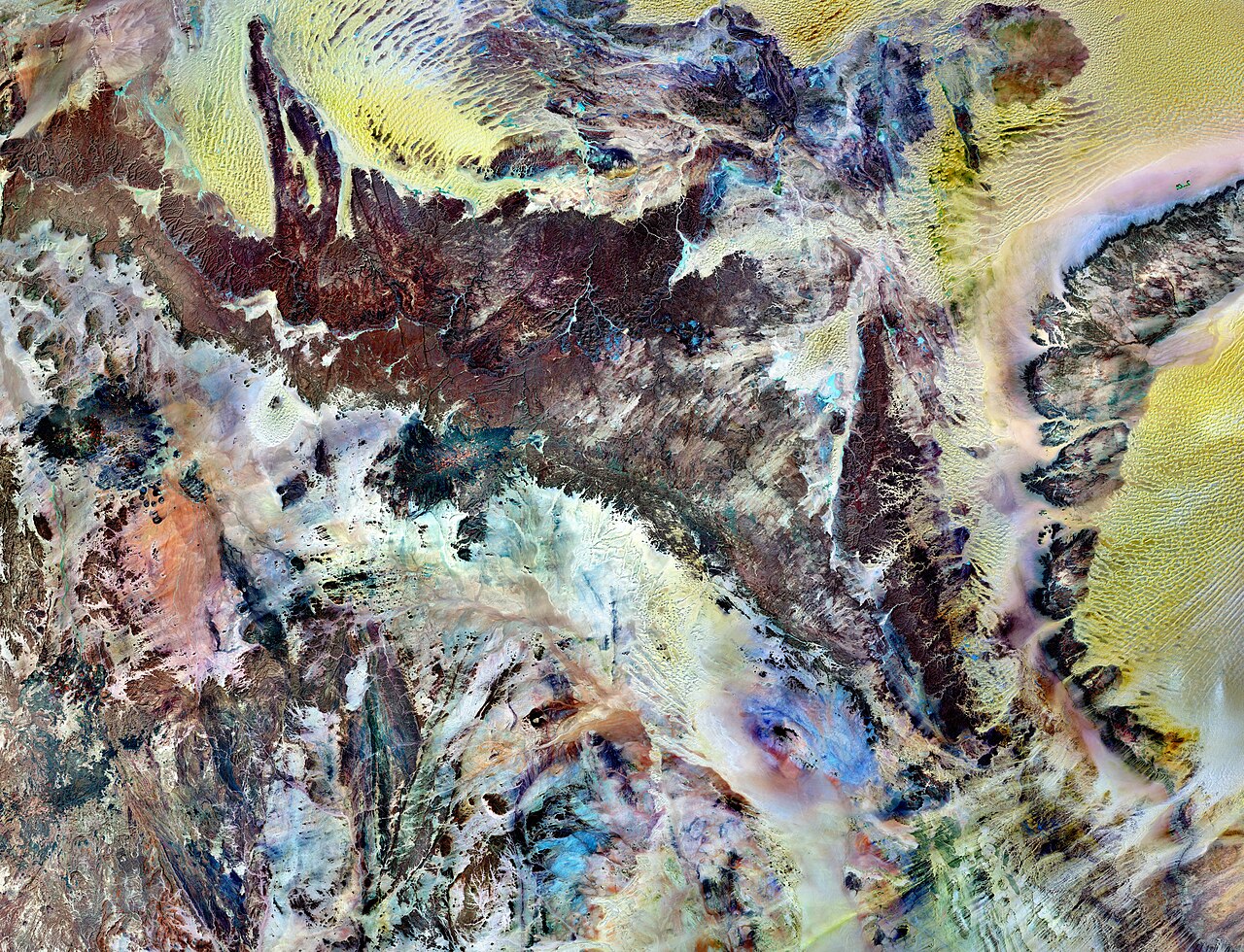
Tassili n’Ajjer National Park covers 72,000 square kilometers (27,800 square miles) in southeastern Algeria. Part of the Sahara Desert, the park has a bone-dry climate with scant rainfall, yet does not blend in with Saharan dunes. Instead, the rocky plateau rises above the surrounding sand seas. Rich in geologic and human history, Tassili n’Ajjer is a United Nations Educational, Scientific and Cultural Organization (UNESCO) World Heritage Site. This image is made from multiple observations by the Landsat 7 satellite in the year 2000. It uses a combination of infrared, near-infrared, and visible light to better distinguish between the park’s various rock types. Sand appears in shades of yellow and tan. Granite rocks appear brick red. Blue areas are likely salts. As the patchwork of colors suggests, the geology of Tassili n’Ajjer is complex. The plateau is composed of sandstone around a mass of granite dating from the Precambrian. Over billions of years, alternating wet and dry climates have shaped these rocks in multiple ways. Deep ravines are cut into cliff faces along the plateau’s northern margin. The ravines are remnants of ancient rivers that once flowed off the plateau into nearby lakes. Where those lakes once rippled, winds now sculpt the dunes of giant sand seas. In drier periods, winds eroded the sandstones of the plateau into “stone forests,” and natural arches. Not surprisingly, the park’s name means “plateau of chasms.” Humans have also modified the park’s rocks. Some 15,000 engravings have so far been identified in Tassili n’Ajjer. From about 10,000 B.C. to the first few centuries A.D., successive populations also left the remains of homes and burial mounds.
|
|||||
| Датум | ||||||
| Извор | NASA Earth Observation Image of the Day, 27 March 2011 | |||||
| Аутор | NASA Landsat 7 image by Michael Taylor, Landsat Science Project Office. Caption by Michon Scott based on image interpretation by Michael Taylor. | |||||
| Дозвола (Поновно коришћење ове датотеке) |
|

.jpg)
| Положај камере | | Ова и друге слике снимљене у близини на: OpenStreetMap |
|---|
.jpg¶ms=024.906667_N_0008.784444_E_globe:Earth_type:camera__&language=sr)
Историја датотеке
Кликните на датум/време да бисте видели тадашњу верзију датотеке.
| Датум/време | Минијатура | Димензије | Корисник | Коментар | |
|---|---|---|---|---|---|
| тренутна | 23:16, 29. јануар 2013. | | 6.357 × 4.869 (9,31 MB) | Slick-o-bot | Bot: convert to a non-interlaced jpeg (see bug #17645) |
| 12:24, 28. март 2011. |  | 6.357 × 4.869 (8,62 MB) | Trialsanderrors | {{Information |Description= Tassili n’Ajjer National Park covers 72,000 square kilometers (27,800 square miles) in southeastern Algeria. Part of the Sahara Desert, the park has a bone-dry climate with scant rainfall, yet does not blend in with Saharan d |
Употреба датотеке
Нема страница које користе ову датотеку.
Глобална употреба датотеке
Други викији који користе ову датотеку:
- Употреба на arz.wikipedia.org
- Употреба на az.wikipedia.org
- Употреба на bg.wikipedia.org
- Употреба на ca.wikipedia.org
- Употреба на ceb.wikipedia.org
- Употреба на cy.wikipedia.org
- Употреба на de.wikivoyage.org
- Употреба на el.wikipedia.org
- Употреба на en.wikipedia.org
- Употреба на en.wikivoyage.org
- Употреба на eo.wikipedia.org
- Употреба на es.wikipedia.org
- Употреба на eu.wikipedia.org
- Употреба на fa.wikipedia.org
- Употреба на fi.wikipedia.org
- Употреба на hr.wikipedia.org
- Употреба на it.wikipedia.org
- Употреба на it.wikivoyage.org
- Употреба на ja.wikivoyage.org
- Употреба на kab.wikipedia.org
- Употреба на ml.wikipedia.org
- Употреба на mt.wikipedia.org
- Употреба на my.wikipedia.org
- Употреба на nn.wikipedia.org
- Употреба на pnb.wikipedia.org
- Употреба на sh.wikipedia.org
- Употреба на simple.wikipedia.org
- Употреба на sl.wikipedia.org
- Употреба на war.wikipedia.org
- Употреба на www.wikidata.org
- Употреба на zh-yue.wikipedia.org
- Употреба на zh.wikipedia.org
.jpg)