Датотека:The Carte of all the Coast of Virginia by Theodor de Bry 1585 1586.jpg

Величина овог приказа: 800 × 591 пиксела. 3 друге резолуције: 320 × 236 пиксела | 640 × 473 пиксела | 1.000 × 739 пиксела.
Оригинална датотека (1.000 × 739 пиксела, величина датотеке: 247 kB, MIME тип: image/jpeg)
| Ово је датотека са Викимедијине оставе. Информације са њене странице са описом приказане су испод. Викимедијина остава је складиште слободно лиценциралних мултимедијалних датотека. И Ви можете да помогнете. |
Опис измене
| Theodor de Bry: The Carte of All the Coast of Virginia
( |
||||||||||||||||||||||||
|---|---|---|---|---|---|---|---|---|---|---|---|---|---|---|---|---|---|---|---|---|---|---|---|---|
| Уметник |
|
|||||||||||||||||||||||
| Наслов |
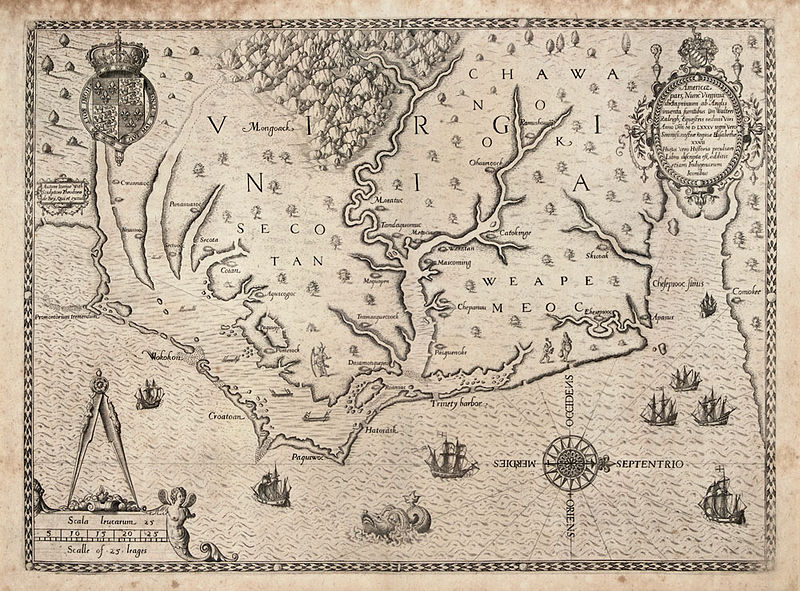
The Carte of All the Coast of Virginia |
|||||||||||||||||||||||
| Опис |
English: "The Carte of All the Coast of Virginia," engraving by Theodor de Bry based on John White's map of the coast of Virginia and North Carolina circa 1585-1586. de Bry's engraving was published in Thomas Hariot's "A Briefe and True Report of the New Found Land of Virginia," published in 1588 and in Vol. 1 of Theodore de Bry’s Great Voyages, printed in French, English and German. This was the first printed map with a high degree of detail and accuracy for any part of the United States. It was the first separate map of Virginia. It was based on a manuscript map by John White from 1585, a copy of which is in the British Museum, revised for additional names and coastal detail gained from Roanoke Colony travels in 1587 and 1588. Quinn notes that White’s original drawing is accepted as the major contemporary authority on the configuration of the coastline in the late sixteenth century. The map was the same in all four editions of Harriot’s work.
John White, one of the company sent by Sir Walter Raleigh to establish an English colony on Roanoke Island in 1585, went at least twice to the Carolina coast in the 1580s. There he produced a series of drawings of the everyday life of the Native American populations. White also compiled this map of the North Carolina coast from Cape Lookout to the mouth of the Chesapeake Bay, based on the British explorations of 1585-86, which de Bry then engraved and published in 1590. |
|||||||||||||||||||||||
| Датум | 1591 | |||||||||||||||||||||||
| Натписи |
Latina: Americae pars, nunc Virginia dicta: primum ab Anglis inuenta, sumtibus Dn. Walteri Raleigh, Equestris ordinis Viri, Anno Dni. MDLXXXV regni Vero Sereniss. nostrae Reginae Elisabethae XXVII, hujus vero Historia peculiari Libro descripta est, additis etiam Indigenarum Iconibus / autore Ioanne With; sculptore Theodoro de Bry, qui et. excud.
English: Part of America, now called Virginia: first discovered by the English, by the expenses of Sir Walter Raleigh, a man of the rank of knight, in the year of the Lord 1585, indeed in the 27th (year) of the rule of our fairest Queen Elizabeth, indeed in that one's (Raleigh's) own book the history was described, also with the images of the natives added / with Ioanne With (John White) the author; with Theodoro de Bry the engraver, who also printed it |
|||||||||||||||||||||||
| Референце |
|
|||||||||||||||||||||||
| Извор/фотограф | http://www.learnnc.org/lp/multimedia/6218 | |||||||||||||||||||||||
| Остале верзије |
|
|||||||||||||||||||||||


Лиценцирање
|
Овај рад је такође у јавном власништву у државама са роком ауторства за живота аутора плус 100 година или мање. Овај рад је у јавном власништву у Сједињеним Државама зато што је објављен или регистрован у канцеларији за ауторска права САД-а пре 1. јануара 1929. | |
| Утврђено је да ова датотека није ограничена у погледу ауторских права, укључујући и сва сродна и суседна права. | |
| Annotations | This image is annotated: View the annotations at Commons |
Историја датотеке
Кликните на датум/време да бисте видели тадашњу верзију датотеке.
| Датум/време | Минијатура | Димензије | Корисник | Коментар | |
|---|---|---|---|---|---|
| тренутна | 18:48, 30. јун 2014. | | 1.000 × 739 (247 kB) | Jarekt | better version from https://www.theantiquarium.com/item/003305/de-bry-virginia |
| 09:23, 15. јун 2010. |  | 682 × 500 (127 kB) | MarmadukePercy | {{Information |Description={{en|1="The Carte of All the Coast of Virginia," engraving by Theodor de Bry based on John White's map of the coast of Virginia and North Carolina circa 1585-1586. de Bry's engraving was published in Thomas Hariot's "A Briefe an |
Употреба датотеке
Следећа страница користи ову датотеку:
Глобална употреба датотеке
Други викији који користе ову датотеку:
- Употреба на ca.wikipedia.org
- Употреба на el.wikipedia.org
- Употреба на en.wikipedia.org
- Употреба на es.wikipedia.org
- Употреба на ja.wikipedia.org
- Употреба на ru.wikipedia.org