Датотека:USA Territorial Growth small.gif
Већа резолуција није доступна.
USA_Territorial_Growth_small.gif (431 × 287 пиксела, величина датотеке: 456 kB, MIME тип: image/gif, петља, 10 кадрова, 30 с)
| Ово је датотека са Викимедијине оставе. Информације са њене странице са описом приказане су испод. Викимедијина остава је складиште слободно лиценциралних мултимедијалних датотека. И Ви можете да помогнете. |

|
Ова датотека је замењена датотеком File:USA territorial growth.gif. Препоручује се да искористите ту датотеку.
|

|
Опис измене
| Опис |
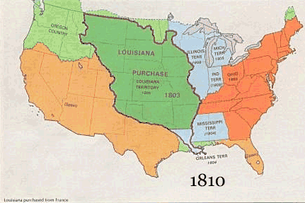
English: US territorial growth 1810–1920, based on the PD USGS maps in Category:Territorial growth maps of the United States.
See key below for explanation of colors.  |
||||||
| Извор |
|
||||||
| Аутор |
|
||||||
| Остале верзије |
|
Лиценцирање
This image is in the public domain in the United States because it only contains materials that originally came from the United States Geological Survey, an agency of the United States Department of the Interior. For more information, see the official USGS copyright policy.
|
Историја датотеке
Кликните на датум/време да бисте видели тадашњу верзију датотеке.
| Датум/време | Минијатура | Димензије | Корисник | Коментар | |
|---|---|---|---|---|---|
| тренутна | 12:50, 30. мај 2006. | | 431 × 287 (456 kB) | Roke~commonswiki | US territorial growth, based on the PD USGS maps in Category:USA Territorial Growth Maps Category: USA Territorial Growth Maps {{PD-USGov-USGS}} |
Употреба датотеке
2 следеће странице користе ову датотеку:
Глобална употреба датотеке
Други викији који користе ову датотеку:
- Употреба на ar.wikipedia.org
- Употреба на be-tarask.wikipedia.org
- Употреба на be.wikipedia.org
- Употреба на ca.wikipedia.org
- Употреба на ckb.wikipedia.org
- Употреба на da.wikipedia.org
- Употреба на fr.wikipedia.org
- Употреба на fy.wikipedia.org
- Употреба на gcr.wikipedia.org
- Употреба на hr.wikipedia.org
- Употреба на id.wikipedia.org
- Употреба на it.wikipedia.org
- Употреба на jv.wikipedia.org
- Употреба на kk.wikipedia.org
- Употреба на ro.wikipedia.org
- Употреба на sh.wikipedia.org
- Употреба на sl.wikipedia.org
- Употреба на tr.wikipedia.org
- Употреба на uk.wikipedia.org