Датотека:World map of countries by ecological footprint (2007).svg

Величина PNG прегледа за ову SVG датотеку је 800 × 353 пиксела. 6 других резолуција: 320 × 141 пиксела | 640 × 283 пиксела | 1.024 × 452 пиксела | 1.280 × 565 пиксела | 2.560 × 1.130 пиксела | 940 × 415 пиксела.
Оригинална датотека (SVG датотека, номинално 940 × 415 пиксела, величина: 1,36 MB)
| Ово је датотека са Викимедијине оставе. Информације са њене странице са описом приказане су испод. Викимедијина остава је складиште слободно лиценциралних мултимедијалних датотека. И Ви можете да помогнете. |
Опис измене
| Опис |
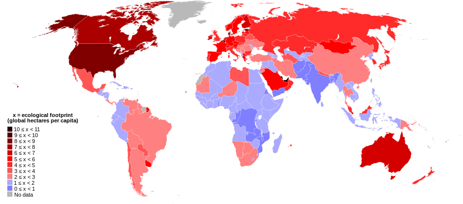
English: World map of countries shaded according to their ecological footprint in 2007 (published on 13 October 2010 by the Global Footprint Network). It is measured by the amount of global hectares that are affected by humans per capita of the country. Lighter shades denote countries with a lower ecological footprint per capita and darker shaded for countries with a higher ecological footprint per capita. The total ecological footprint (global hectares affected by humans) is measured as a total of six factors: cropland footprint, grazing footprint, forest footprint, fishing ground footprint, carbon footprint and built-up land.
Français : Mapemonde colorée selon l'empreinte écologique moyenne des habitants de chaque pays, exprimée en ha par personne, en 2007. Le tons plus chairs correspondent à une empreinte faible, les tons plus sombres à une empreinte plus forte. Six facteurs sont pris en compte pour mesurer cette empreinte: L'agriculture, le pâturage, l'exploitation forestière, la pêche, la production de carbone et l'urbanisation.
No data
0 ≤ x < 1
1 ≤ x < 2
2 ≤ x < 3
3 ≤ x < 4
4 ≤ x < 5
5 ≤ x < 6
6 ≤ x < 1
7 ≤ x < 8
8 ≤ x < 9
9 ≤ x < 10
10 ≤ x < 11 |
| Датум | |
| Извор | Self-made with data from list of countries by ecological footprint. |
| Аутор | Jolly Janner |
| Остале верзије |
|


.svg)
Лиценцирање
| Ја, творац овог дела, предајем га у јавно власништво. Ово се односи на цео свет. У неким земљама, ово није законски могуће; у том случају: Ја, творац овог дела дозвољавам свакоме да користи ово дело за било коју намену, без било каквих услова, осим услова које намеће закон. |
Историја датотеке
Кликните на датум/време да бисте видели тадашњу верзију датотеке.
| Датум/време | Минијатура | Димензије | Корисник | Коментар | |
|---|---|---|---|---|---|
| тренутна | 03:24, 30. март 2018. | | 940 × 415 (1,36 MB) | Sisgeo | Employ a different color for countries under 2.1 gHa, the estimated limit of sustainability. |
| 20:44, 29. октобар 2010. |  | 940 × 415 (1,68 MB) | Jolly Janner | Added a white box to represent the background | |
| 20:38, 29. октобар 2010. |  | 940 × 415 (1,68 MB) | Jolly Janner | white background | |
| 20:36, 29. октобар 2010. |  | 940 × 415 (1,68 MB) | Jolly Janner | white background | |
| 20:24, 29. октобар 2010. |  | 940 × 415 (1,68 MB) | Jolly Janner | == {{int:filedesc}} == {{Information |Description={{en|1=World map of countries shaded according to their ecological footprint in 2007 (published on 13 October 2010 by the Global Footprint Network). It is measured by the amoun |
Употреба датотеке
Следећа страница користи ову датотеку:
Глобална употреба датотеке
Други викији који користе ову датотеку:
- Употреба на ca.wikipedia.org
- Употреба на el.wikipedia.org
- Употреба на en.wikipedia.org
- Употреба на en.wikibooks.org
- Употреба на eu.wikipedia.org
- Употреба на fa.wikipedia.org
- Употреба на fr.wikipedia.org
- Употреба на gl.wikipedia.org
- Употреба на hi.wikipedia.org
- Употреба на it.wikipedia.org
- Употреба на ms.wikipedia.org
- Употреба на nl.wikipedia.org
- Употреба на pl.wikipedia.org
- Употреба на pl.wikibooks.org
- Употреба на ro.wikipedia.org
- Употреба на sk.wikipedia.org
- Употреба на ta.wikipedia.org
- Употреба на uk.wikipedia.org
- Употреба на zh.wikipedia.org
.svg)